
Mt. Gankyoujiyama
願教寺山
Ōno-shi, Fukui · Elevation 1,691 m
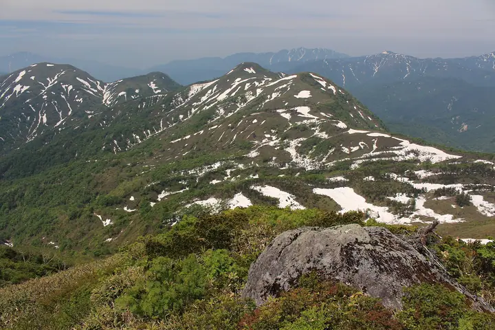
Mt. Gankyoujiyama is a 1,690.67-meter peak in the southern Hakusan Range on the border between Gujō City (Gifu) and Ōno City (Fukui), featured in the Gifu Hyakuzan, Gifu Hyakushūzan, and Nihon-no-Yama 1000 lists. Its Fukui-side slopes were designated a Class 1 Special Protection Zone of Hakusan National Park in 1962. There is no maintained hiking trail — the densely brushed summit is reached almost exclusively as a residual-snow ski-mountaineering or bushwhacking objective, with the historic Hakusan Mino-Zenjō-dō pilgrimage trail passing nearby but bypassing the summit.
Mt. Gankyoujiyama at a glance
- Weather: The most settled day in the next 7 days is Sun, November 8: clear, gusts up to 8 m/s. Sat, Nov 7: strong wind (gusts up to 15 m/s).
Mt. Gankyoujiyama weather (hourly, 14 days)
Sunrise today 06:17, sunset 16:57
| Tue, 11/3 | Wed, 11/4 | Thu, 11/5 | Fri, 11/6 | Sat, 11/7 | Sun, 11/8 | Mon, 11/9 | Tue, 11/10 | Wed, 11/11 | Thu, 11/12 | Fri, 11/13 | Sat, 11/14 | Sun, 11/15 | Mon, 11/16 | Tue, 11/17 | |||||||||||||||||||||||||||||||||||||||||||||||||||||||||||||||||||||||
|---|---|---|---|---|---|---|---|---|---|---|---|---|---|---|---|---|---|---|---|---|---|---|---|---|---|---|---|---|---|---|---|---|---|---|---|---|---|---|---|---|---|---|---|---|---|---|---|---|---|---|---|---|---|---|---|---|---|---|---|---|---|---|---|---|---|---|---|---|---|---|---|---|---|---|---|---|---|---|---|---|---|---|---|---|---|
| Japan time | 15 | 17 | 19 | 21 | 23 | 1 | 3 | 5 | 7 | 9 | 11 | 13 | 15 | 18 | 21 | 0 | 3 | 6 | 9 | 12 | 15 | 18 | 21 | 0 | 3 | 6 | 9 | 12 | 15 | 18 | 21 | 0 | 3 | 6 | 9 | 12 | 15 | 18 | 21 | 0 | 3 | 6 | 9 | 12 | 15 | 18 | 21 | 0 | 3 | 6 | 9 | 15 | 21 | 3 | 9 | 15 | 21 | 3 | 9 | 15 | 21 | 3 | 9 | 15 | 21 | 3 | 9 | 15 | 21 | 3 | 9 | 15 | 21 | 3 | 9 | 15 | 21 | 3 | 9 | 15 | 21 | 3 | 9 | 15 | |
  |  | |   | | | | | |  | | |   |   | |   | | |   | | |   | | | | | | |   | | | |   | |   | |   |   | |   | | | | | | | | | | | |   | | | | | | | |   | |  | | | | | | | | | | | | | | | | | | |   | | |   | ||
| Temperature | °C | 8° | 4° | 0° | -1° | -1° | -1° | -1° | -2° | -1° | 8° | 10° | 11° | 10° | 7° | 6° | 7° | 7° | 7° | 9° | 11° | 12° | 8° | 7° | 7° | 7° | 7° | 7° | 9° | 6° | 3° | 2° | 0° | -1° | -1° | 0° | 1° | 0° | -2° | -2° | -3° | -3° | -3° | 2° | 5° | 4° | 1° | 0° | 1° | 0° | 0° | 4° | 5° | -3° | -3° | 3° | 3° | 0° | -4° | -1° | 0° | -4° | -6° | 2° | 3° | -3° | 0° | 1° | 2° | -4° | -4° | 4° | 6° | 1° | 2° | 4° | 6° | 5° | 6° | 7° | 5° | -1° | -2° | 4° | 5° |
| Precipitation | mm | 0.9 | 7 | 4.4 | 3.2 | 0.4 | 0.6 | 0.1 | 7 | 1.6 | 0.6 | 0.8 | 1.5 | 0.9 | 0.5 | 0.6 | 0.6 | 0.8 | 0.6 | 0.6 | 0.2 | 0.1 | 0.4 | 0.8 | 0.4 | 0.6 | 8 | 5 | 0.7 | 0.7 | 0.8 | 0.9 | 0.2 | 0.7 | 6 | 15 | 6 | 1.1 | 0.3 | ||||||||||||||||||||||||||||||||||||||||||||||
| New snow | cm | <.1 | <.1 | 0.3 | 0.2 | 0.2 | <.1 | <.1 | <.1 | <.1 | 0.2 | 3.0 | 0.7 | 0.3 | <.1 | ||||||||||||||||||||||||||||||||||||||||||||||||||||||||||||||||||||||
| Snow depth | cm | 0 | 0 | 0 | 0 | 0 | 0 | 0 | 0 | 0 | 0 | 0 | 0 | 0 | 0 | 0 | 0 | 0 | 0 | 0 | 0 | 0 | 0 | 0 | 0 | 0 | 0 | 0 | 0 | 0 | 0 | 0 | 0 | 0 | <1 | <1 | <1 | <1 | <1 | <1 | <1 | <1 | <1 | <1 | <1 | <1 | <1 | 0 | 0 | 0 | 0 | 0 | 0 | 0 | 0 | 0 | 0 | <1 | 2 | 2 | 1 | 1 | 1 | 1 | <1 | <1 | <1 | <1 | <1 | <1 | <1 | <1 | <1 | <1 | <1 | 0 | 0 | 0 | 0 | 0 | 0 | 0 | 0 | 0 | 0 |
| Wind | m/s | 2 | 1 | 2 | 2 | 2 | 2 | 2 | 2 | 2 | 1 | 2 | 3 | 3 | 1 | 1 | 0 | 1 | 0 | 1 | 1 | 2 | 0 | 0 | 0 | 2 | 2 | 3 | 5 | 4 | 3 | 4 | 4 | 4 | 3 | 4 | 5 | 4 | 3 | 3 | 2 | 2 | 2 | 1 | 3 | 1 | 1 | 1 | 1 | 1 | 1 | 2 | 2 | 2 | 2 | 2 | 3 | 2 | 5 | 5 | 4 | 2 | 2 | 0 | 3 | 1 | 2 | 3 | 3 | 2 | 1 | 1 | 3 | 1 | 1 | 2 | 2 | 1 | 0 | 2 | 5 | 3 | 2 | 1 | 2 |
| Wind gusts | m/s | 8 | 7 | 5 | 5 | 6 | 6 | 5 | 5 | 5 | 5 | 7 | 8 | 9 | 7 | 6 | 6 | 6 | 6 | 6 | 5 | 7 | 5 | 3 | 4 | 8 | 8 | 10 | 14 | 14 | 12 | 12 | 13 | 13 | 12 | 12 | 15 | 15 | 13 | 10 | 9 | 9 | 9 | 8 | 8 | 8 | 5 | 4 | 4 | 5 | 5 | 6 | 10 | 7 | 6 | 7 | 12 | 9 | 18 | 18 | 17 | 13 | 7 | 5 | 9 | 9 | 7 | 10 | 12 | 11 | 7 | 4 | 7 | 7 | 4 | 7 | 8 | 10 | 8 | 7 | 15 | 15 | 9 | 5 | 7 |
| Wind dir. | ↓ | ↓ | ↓ | ↓ | ↓ | ↓ | ↓ | ↓ | ↓ | ↓ | ↓ | ↓ | ↓ | ↓ | ↓ | ↓ | ↓ | ↓ | ↓ | ↓ | ↓ | ↓ | ↓ | ↓ | ↓ | ↓ | ↓ | ↓ | ↓ | ↓ | ↓ | ↓ | ↓ | ↓ | ↓ | ↓ | ↓ | ↓ | ↓ | ↓ | ↓ | ↓ | ↓ | ↓ | ↓ | ↓ | ↓ | ↓ | ↓ | ↓ | ↓ | ↓ | ↓ | ↓ | ↓ | ↓ | ↓ | ↓ | ↓ | ↓ | ↓ | ↓ | ↓ | ↓ | ↓ | ↓ | ↓ | ↓ | ↓ | ↓ | ↓ | ↓ | ↓ | ↓ | ↓ | ↓ | ↓ | ↓ | ↓ | ↓ | ↓ | ↓ | ↓ | ↓ | |
Huts, campsites and lodging near Mt. Gankyoujiyama
Mountain huts
Lists that include Mt. Gankyoujiyama
100 Mountains of Gifu · Elevations of 1003 Mountains of Japan · 1000 Mountains of Japan
Mt. Gankyoujiyama facts
- Elevation
- 1,691 m
- Location
- Ōno-shi, Fukui
36.056945, 136.739761 - National Park
- 白山国立公園
- Website
- fncc.pref.fukui.lg.jp (PDF)
- Wikipedia
- ja.wikipedia.org