
Mt. Sannomine
三ノ峰
Takayama, Gifu / Hakusan, Ishikawa / Ōno-shi, Fukui · Elevation 2,128 m
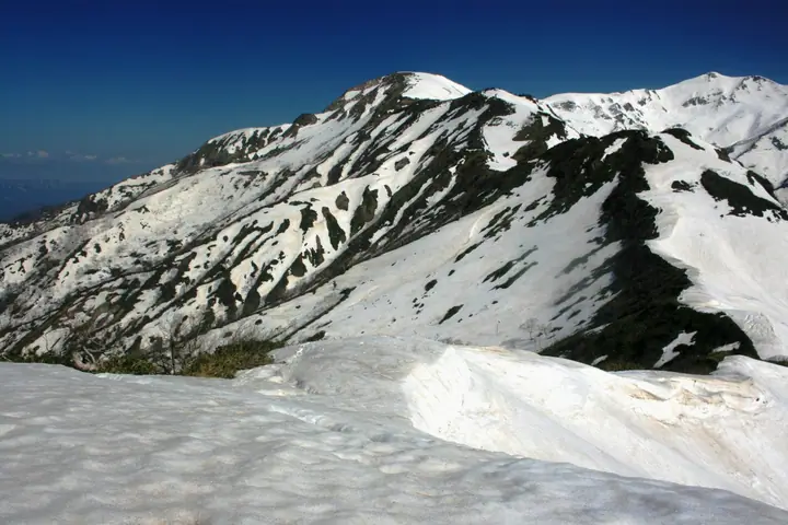
Mt. Sannomine is a 2,128-meter peak on the border between Hakusan City (Ishikawa) and Takayama City (Gifu) within Hakusan National Park, in the southern Hakusan Range. Approximately 300 meters to the south stands Echizen-Sannomine (2,095 m), marking the meeting point of Fukui, Gifu, and Ishikawa prefectures; together with Ichinomine and Ninomine to the south the ridge forms the southernmost over-2000 m crest in Japan and is a renowned alpine-flower stronghold. Listed in Zoku Gifu Hyakuzan, Hida Hyakuzan, Ishikawa-no-Yama, and the Fukui Prefecture mountain guide, it is reached primarily via the Kamikoike route from Ōno City (Fukui), the Bessan-daira ridge traverse, and the Mino-Zenjō-dō from Itoshiro; an emergency hut (Sannomine Hinangoya) sits just below the summit.
Mt. Sannomine at a glance
- Weather: The most settled day in the next 7 days is Sun, November 8: clear, gusts up to 8 m/s. Sat, Nov 7: strong wind (gusts up to 15 m/s).
- Route: The shortest is Itoshiro Trailhead to Mount Sannomine Out-and-Back: about 10 h 25 min, 16.2 km, about 1,560 m of climbing.
Mt. Sannomine weather (hourly, 14 days)
Sunrise today 06:17, sunset 16:56
| Tue, 11/3 | Wed, 11/4 | Thu, 11/5 | Fri, 11/6 | Sat, 11/7 | Sun, 11/8 | Mon, 11/9 | Tue, 11/10 | Wed, 11/11 | Thu, 11/12 | Fri, 11/13 | Sat, 11/14 | Sun, 11/15 | Mon, 11/16 | Tue, 11/17 | |||||||||||||||||||||||||||||||||||||||||||||||||||||||||||||||||||||||
|---|---|---|---|---|---|---|---|---|---|---|---|---|---|---|---|---|---|---|---|---|---|---|---|---|---|---|---|---|---|---|---|---|---|---|---|---|---|---|---|---|---|---|---|---|---|---|---|---|---|---|---|---|---|---|---|---|---|---|---|---|---|---|---|---|---|---|---|---|---|---|---|---|---|---|---|---|---|---|---|---|---|---|---|---|---|
| Japan time | 15 | 17 | 19 | 21 | 23 | 1 | 3 | 5 | 7 | 9 | 11 | 13 | 15 | 18 | 21 | 0 | 3 | 6 | 9 | 12 | 15 | 18 | 21 | 0 | 3 | 6 | 9 | 12 | 15 | 18 | 21 | 0 | 3 | 6 | 9 | 12 | 15 | 18 | 21 | 0 | 3 | 6 | 9 | 12 | 15 | 18 | 21 | 0 | 3 | 6 | 9 | 15 | 21 | 3 | 9 | 15 | 21 | 3 | 9 | 15 | 21 | 3 | 9 | 15 | 21 | 3 | 9 | 15 | 21 | 3 | 9 | 15 | 21 | 3 | 9 | 15 | 21 | 3 | 9 | 15 | 21 | 3 | 9 | 15 | |
  |  | |   | | | | | |  | | |   |   | |   | | |   | | |   | | | | | | |   | | | |   | |   | |   |   | |   | | | | | | | | | | | |   | | | | | | | |   | |  | | | | | | | | | | | | | | | | | | |   | | |   | ||
| Temperature | °C | 5° | 1° | -3° | -4° | -4° | -3° | -4° | -5° | -4° | 5° | 7° | 8° | 7° | 4° | 3° | 4° | 4° | 4° | 6° | 8° | 9° | 5° | 5° | 4° | 4° | 4° | 4° | 6° | 3° | 1° | -1° | -3° | -4° | -4° | -3° | -2° | -3° | -5° | -5° | -6° | -6° | -5° | -1° | 2° | 1° | -2° | -3° | -2° | -3° | -2° | 1° | 2° | -6° | -6° | 0° | 1° | -3° | -7° | -4° | -3° | -7° | -9° | -1° | 0° | -6° | -3° | -2° | 0° | -7° | -7° | 1° | 3° | -1° | -1° | 1° | 3° | 3° | 3° | 4° | 2° | -4° | -5° | 1° | 2° |
| Precipitation | mm | 0.9 | 7 | 4.4 | 3.2 | 0.4 | 0.6 | 0.1 | 7 | 1.6 | 0.6 | 0.8 | 1.5 | 0.9 | 0.5 | 0.6 | 0.6 | 0.8 | 0.6 | 0.6 | 0.2 | 0.1 | 0.4 | 0.8 | 0.4 | 0.6 | 8 | 5 | 0.7 | 0.7 | 0.8 | 0.9 | 0.2 | 0.7 | 6 | 15 | 6 | 1.1 | 0.3 | ||||||||||||||||||||||||||||||||||||||||||||||
| New snow | cm | <.1 | <.1 | 0.3 | 0.2 | 0.2 | <.1 | <.1 | <.1 | <.1 | 0.2 | 3.0 | 0.7 | 0.3 | <.1 | ||||||||||||||||||||||||||||||||||||||||||||||||||||||||||||||||||||||
| Snow depth | cm | 0 | 0 | 0 | 0 | 0 | 0 | 0 | 0 | 0 | 0 | 0 | 0 | 0 | 0 | 0 | 0 | 0 | 0 | 0 | 0 | 0 | 0 | 0 | 0 | 0 | 0 | 0 | 0 | 0 | 0 | 0 | 0 | 0 | <1 | <1 | <1 | <1 | <1 | <1 | <1 | <1 | <1 | <1 | <1 | <1 | <1 | 0 | 0 | 0 | 0 | 0 | 0 | 0 | 0 | 0 | 0 | <1 | 2 | 2 | 1 | 1 | 1 | 1 | <1 | <1 | <1 | <1 | <1 | <1 | <1 | <1 | <1 | <1 | <1 | 0 | 0 | 0 | 0 | 0 | 0 | 0 | 0 | 0 | 0 |
| Wind | m/s | 2 | 1 | 2 | 2 | 2 | 2 | 2 | 2 | 2 | 1 | 2 | 3 | 3 | 1 | 1 | 0 | 1 | 0 | 1 | 1 | 2 | 0 | 0 | 0 | 2 | 2 | 3 | 5 | 4 | 3 | 4 | 4 | 4 | 3 | 4 | 5 | 4 | 3 | 3 | 2 | 2 | 2 | 1 | 3 | 1 | 1 | 1 | 1 | 1 | 1 | 2 | 2 | 2 | 2 | 2 | 3 | 2 | 5 | 5 | 4 | 2 | 2 | 0 | 3 | 1 | 2 | 3 | 3 | 2 | 1 | 1 | 3 | 1 | 1 | 2 | 2 | 1 | 0 | 2 | 5 | 3 | 2 | 1 | 2 |
| Wind gusts | m/s | 8 | 7 | 5 | 5 | 6 | 6 | 5 | 5 | 5 | 5 | 7 | 8 | 9 | 7 | 6 | 6 | 6 | 6 | 6 | 5 | 7 | 5 | 3 | 4 | 8 | 8 | 10 | 14 | 14 | 12 | 12 | 13 | 13 | 12 | 12 | 15 | 15 | 13 | 10 | 9 | 9 | 9 | 8 | 8 | 8 | 5 | 4 | 4 | 5 | 5 | 6 | 10 | 7 | 6 | 7 | 12 | 9 | 18 | 18 | 17 | 13 | 7 | 5 | 9 | 9 | 7 | 10 | 12 | 11 | 7 | 4 | 7 | 7 | 4 | 7 | 8 | 10 | 8 | 7 | 15 | 15 | 9 | 5 | 7 |
| Wind dir. | ↓ | ↓ | ↓ | ↓ | ↓ | ↓ | ↓ | ↓ | ↓ | ↓ | ↓ | ↓ | ↓ | ↓ | ↓ | ↓ | ↓ | ↓ | ↓ | ↓ | ↓ | ↓ | ↓ | ↓ | ↓ | ↓ | ↓ | ↓ | ↓ | ↓ | ↓ | ↓ | ↓ | ↓ | ↓ | ↓ | ↓ | ↓ | ↓ | ↓ | ↓ | ↓ | ↓ | ↓ | ↓ | ↓ | ↓ | ↓ | ↓ | ↓ | ↓ | ↓ | ↓ | ↓ | ↓ | ↓ | ↓ | ↓ | ↓ | ↓ | ↓ | ↓ | ↓ | ↓ | ↓ | ↓ | ↓ | ↓ | ↓ | ↓ | ↓ | ↓ | ↓ | ↓ | ↓ | ↓ | ↓ | ↓ | ↓ | ↓ | ↓ | ↓ | ↓ | ↓ | |
Mt. Sannomine hiking routes
Hiking times are estimates calculated from the terrain.
Huts, campsites and lodging near Mt. Sannomine
Mountain huts
Mt. Sannomine facts
- Elevation
- 2,128 m
- Location
- Takayama, Gifu / Hakusan, Ishikawa / Ōno-shi, Fukui
36.088913, 136.754433 - National Park
- 白山国立公園
- Website
- www.city.ono.fukui.jp
- Trail Map
- www.pref.ishikawa.lg.jp
- Wikipedia
- ja.wikipedia.org