
Mt. Nobusegatake
野伏ヶ岳
Gujō-shi, Gifu · Elevation 1,674 m
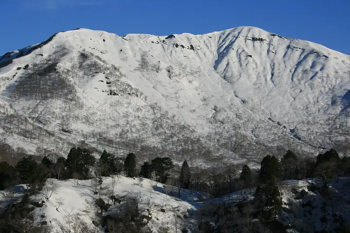
Mt. Nobusegatake (1,674 m) sits on the border between Ono City (Fukui) and the Shirotori district of Gujo City (Gifu), in the southern part of the Ryohaku mountain range. Because of the area's heavy snowfall, no maintained summer trail exists; the peak is climbed almost exclusively in residual-snow season from late March to mid-April, via a forest road from Hakusan-Chukyo Shrine and the so-called "direct ridge." It is included in Japan's 300 Famous Mountains and the 100 Mountains of Gifu, and the summit offers views of Hakusan, the Northern Alps and Mt. Ontake.
Mt. Nobusegatake at a glance
- Weather: The most settled day in the next 7 days is Sun, November 8: clear, gusts up to 7 m/s. Sat, Nov 7: strong wind (gusts up to 15 m/s).
Mt. Nobusegatake weather (hourly, 14 days)
Sunrise today 06:17, sunset 16:57
| Tue, 11/3 | Wed, 11/4 | Thu, 11/5 | Fri, 11/6 | Sat, 11/7 | Sun, 11/8 | Mon, 11/9 | Tue, 11/10 | Wed, 11/11 | Thu, 11/12 | Fri, 11/13 | Sat, 11/14 | Sun, 11/15 | Mon, 11/16 | Tue, 11/17 | |||||||||||||||||||||||||||||||||||||||||||||||||||||||||||||||||||||||
|---|---|---|---|---|---|---|---|---|---|---|---|---|---|---|---|---|---|---|---|---|---|---|---|---|---|---|---|---|---|---|---|---|---|---|---|---|---|---|---|---|---|---|---|---|---|---|---|---|---|---|---|---|---|---|---|---|---|---|---|---|---|---|---|---|---|---|---|---|---|---|---|---|---|---|---|---|---|---|---|---|---|---|---|---|---|
| Japan time | 21 | 23 | 1 | 3 | 5 | 7 | 9 | 11 | 13 | 15 | 17 | 19 | 21 | 0 | 3 | 6 | 9 | 12 | 15 | 18 | 21 | 0 | 3 | 6 | 9 | 12 | 15 | 18 | 21 | 0 | 3 | 6 | 9 | 12 | 15 | 18 | 21 | 0 | 3 | 6 | 9 | 12 | 15 | 18 | 21 | 0 | 3 | 6 | 9 | 12 | 15 | 21 | 3 | 9 | 15 | 21 | 3 | 9 | 15 | 21 | 3 | 9 | 15 | 21 | 3 | 9 | 15 | 21 | 3 | 9 | 15 | 21 | 3 | 9 | 15 | 21 | 3 | 9 | 15 | 21 | 3 | 9 | 15 | 21 | |
  | | |  | |   | | | |   |   | | |   | | | |   |   | | | | | |   | | | | | |   | |   | | |   | | |   | | | | | | | | | |  | | | | | | | | |   |   | |  | | | | | | | | | | | | | | | | | | |   | | | | | ||
| Temperature | °C | -2° | -1° | 0° | -1° | -2° | -1° | 7° | 10° | 11° | 10° | 7° | 6° | 6° | 7° | 7° | 7° | 10° | 13° | 12° | 9° | 7° | 8° | 7° | 6° | 7° | 8° | 5° | 3° | 2° | 0° | -1° | -2° | -1° | 1° | 0° | -2° | -2° | -3° | -3° | -3° | 2° | 6° | 5° | 1° | 1° | 2° | 2° | 2° | 5° | 7° | 5° | -3° | -3° | 3° | 4° | 0° | -4° | -1° | 0° | -4° | -6° | 2° | 3° | -3° | 0° | 1° | 3° | -4° | -4° | 4° | 6° | 1° | 2° | 4° | 6° | 6° | 6° | 7° | 5° | -1° | -2° | 4° | 5° | 2° |
| Precipitation | mm | 3.4 | 6 | 1.0 | 0.1 | 0.4 | 2.1 | 6 | 6 | 1.1 | 0.5 | 1.0 | 1.7 | 0.6 | 1.1 | 0.7 | 0.5 | 0.5 | 0.6 | 0.5 | 0.5 | 0.6 | 8 | 5 | 0.7 | 0.7 | 0.8 | 0.9 | 0.2 | 0.7 | 6 | 15 | 6 | 1.1 | 0.3 | 1.1 | |||||||||||||||||||||||||||||||||||||||||||||||||
| New snow | cm | <.1 | 0.1 | 0.2 | 0.2 | 0.2 | <.1 | <.1 | <.1 | 0.2 | 3.0 | 0.7 | 0.3 | <.1 | |||||||||||||||||||||||||||||||||||||||||||||||||||||||||||||||||||||||
| Snow depth | cm | 0 | 0 | 0 | 0 | 0 | 0 | 0 | 0 | 0 | 0 | 0 | 0 | 0 | 0 | 0 | 0 | 0 | 0 | 0 | 0 | 0 | 0 | 0 | 0 | 0 | 0 | 0 | 0 | 0 | 0 | 0 | <1 | <1 | <1 | <1 | <1 | <1 | <1 | <1 | <1 | <1 | <1 | <1 | <1 | 0 | 0 | 0 | 0 | 0 | 0 | 0 | 0 | 0 | 0 | 0 | <1 | 2 | 2 | 1 | 1 | 1 | 1 | <1 | <1 | <1 | <1 | <1 | <1 | <1 | <1 | <1 | <1 | <1 | 0 | 0 | 0 | 0 | 0 | 0 | 0 | 0 | 0 | 0 | 0 |
| Wind | m/s | 2 | 2 | 2 | 2 | 2 | 2 | 1 | 3 | 3 | 3 | 1 | 1 | 1 | 0 | 1 | 1 | 0 | 1 | 1 | 1 | 2 | 1 | 3 | 3 | 3 | 5 | 4 | 3 | 3 | 2 | 3 | 3 | 3 | 5 | 5 | 3 | 3 | 3 | 3 | 2 | 2 | 1 | 0 | 1 | 1 | 1 | 0 | 0 | 1 | 3 | 3 | 2 | 2 | 2 | 3 | 2 | 5 | 5 | 4 | 2 | 2 | 0 | 3 | 1 | 2 | 3 | 3 | 2 | 1 | 1 | 3 | 1 | 1 | 2 | 2 | 1 | 0 | 2 | 5 | 3 | 2 | 1 | 2 | 1 |
| Wind gusts | m/s | 5 | 5 | 5 | 5 | 5 | 5 | 5 | 8 | 8 | 9 | 7 | 5 | 5 | 5 | 7 | 6 | 3 | 5 | 5 | 5 | 7 | 8 | 9 | 9 | 10 | 14 | 15 | 12 | 11 | 12 | 11 | 11 | 11 | 15 | 15 | 14 | 11 | 11 | 11 | 10 | 7 | 6 | 5 | 4 | 4 | 4 | 4 | 4 | 5 | 11 | 11 | 7 | 6 | 7 | 12 | 9 | 18 | 18 | 17 | 13 | 7 | 5 | 9 | 9 | 7 | 10 | 12 | 11 | 7 | 4 | 7 | 7 | 4 | 7 | 8 | 10 | 8 | 7 | 15 | 15 | 9 | 5 | 7 | 6 |
| Wind dir. | ↓ | ↓ | ↓ | ↓ | ↓ | ↓ | ↓ | ↓ | ↓ | ↓ | ↓ | ↓ | ↓ | ↓ | ↓ | ↓ | ↓ | ↓ | ↓ | ↓ | ↓ | ↓ | ↓ | ↓ | ↓ | ↓ | ↓ | ↓ | ↓ | ↓ | ↓ | ↓ | ↓ | ↓ | ↓ | ↓ | ↓ | ↓ | ↓ | ↓ | ↓ | ↓ | ↓ | ↓ | ↓ | ↓ | ↓ | ↓ | ↓ | ↓ | ↓ | ↓ | ↓ | ↓ | ↓ | ↓ | ↓ | ↓ | ↓ | ↓ | ↓ | ↓ | ↓ | ↓ | ↓ | ↓ | ↓ | ↓ | ↓ | ↓ | ↓ | ↓ | ↓ | ↓ | ↓ | ↓ | ↓ | ↓ | ↓ | ↓ | ↓ | ↓ | ↓ | ↓ | |
Lists that include Mt. Nobusegatake
Japan's 300 Famous Mountains · 100 Mountains of Gifu · Elevations of 1003 Mountains of Japan · 1000 Mountains of Japan
Mt. Nobusegatake facts
- Elevation
- 1,674 m
- Location
- Gujō-shi, Gifu
36.012849, 136.732385 - Wikipedia
- ja.wikipedia.org