
Mt. Akausagiyama
赤兎山
Ōno-shi, Fukui · Elevation 1,628 m
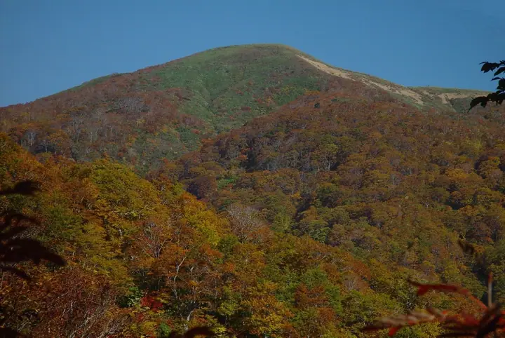
Mt. Akausagiyama is a 1,628-meter peak straddling Hakusan City (Ishikawa) and Ōno City (Fukui) in the Ryōhaku Range and within Hakusan National Park. The mountain's gently rounded form — resembling a rabbit's back — gave it its name, and ridges with maintained trails radiate from the summit in all four cardinal directions. The Akaike Wetland east of the summit is Fukui Prefecture's only alpine bog and hosts Nikkō-kisuge and kobaikeisō in season. The standard route climbs from Kohara in Katsuyama City via the Kohara-rindō and Kohara-tōge in roughly four hours; the peak appears in the Hokuriku Hyakuzan, Hokuriku-Shinkansen Hyakumeizan, and both Ishikawa and Fukui prefectural mountain guides.
Mt. Akausagiyama at a glance
- Weather: The most settled day in the next 7 days is Wed, November 4: clear, gusts up to 7 m/s. Sat, Nov 7: strong wind (gusts up to 15 m/s).
- Route: The shortest is Mount Akausagi and Akausagi-daira Out-and-Back from Obara: about 3 h 40 min, 5.7 km, about 560 m of climbing.
Mt. Akausagiyama weather (hourly, 14 days)
Sunrise today 06:17, sunset 16:57
| Tue, 11/3 | Wed, 11/4 | Thu, 11/5 | Fri, 11/6 | Sat, 11/7 | Sun, 11/8 | Mon, 11/9 | Tue, 11/10 | Wed, 11/11 | Thu, 11/12 | Fri, 11/13 | Sat, 11/14 | Sun, 11/15 | Mon, 11/16 | Tue, 11/17 | |||||||||||||||||||||||||||||||||||||||||||||||||||||||||||||||||||||||
|---|---|---|---|---|---|---|---|---|---|---|---|---|---|---|---|---|---|---|---|---|---|---|---|---|---|---|---|---|---|---|---|---|---|---|---|---|---|---|---|---|---|---|---|---|---|---|---|---|---|---|---|---|---|---|---|---|---|---|---|---|---|---|---|---|---|---|---|---|---|---|---|---|---|---|---|---|---|---|---|---|---|---|---|---|---|
| Japan time | 15 | 17 | 19 | 21 | 23 | 1 | 3 | 5 | 7 | 9 | 11 | 13 | 15 | 18 | 21 | 0 | 3 | 6 | 9 | 12 | 15 | 18 | 21 | 0 | 3 | 6 | 9 | 12 | 15 | 18 | 21 | 0 | 3 | 6 | 9 | 12 | 15 | 18 | 21 | 0 | 3 | 6 | 9 | 12 | 15 | 18 | 21 | 0 | 3 | 6 | 9 | 15 | 21 | 3 | 9 | 15 | 21 | 3 | 9 | 15 | 21 | 3 | 9 | 15 | 21 | 3 | 9 | 15 | 21 | 3 | 9 | 15 | 21 | 3 | 9 | 15 | 21 | 3 | 9 | 15 | 21 | 3 | 9 | 15 | |
  |  | |   | | | | | |  | | |   |   | |   | | |   | | |   | | | | | |   |   | | | | |   |   | |   |   |   | | | | | | | | | | | | | | | | | | | |   | | | | | | | | | |  | | | | | | | | | | | |   | | |   | ||
| Temperature | °C | 8° | 4° | 1° | -1° | -1° | -1° | -1° | -3° | -1° | 8° | 11° | 12° | 10° | 7° | 6° | 7° | 6° | 7° | 9° | 12° | 12° | 9° | 8° | 7° | 7° | 7° | 7° | 9° | 6° | 4° | 2° | 1° | 0° | -1° | 0° | 1° | 1° | -1° | -1° | -2° | -2° | -1° | 2° | 5° | 4° | 2° | 1° | 1° | 1° | 1° | 4° | 5° | -2° | -3° | 4° | 4° | 1° | -3° | -1° | 1° | -3° | -6° | 2° | 3° | -3° | 0° | 1° | 3° | -4° | -4° | 5° | 8° | 1° | 2° | 5° | 7° | 6° | 6° | 7° | 5° | 0° | -3° | 2° | 5° |
| Precipitation | mm | 1.1 | 6 | 3.4 | 2.7 | 0.3 | 0.4 | 0.2 | 8 | 1.9 | 1.3 | 1.5 | 1.8 | 0.9 | 0.6 | 0.9 | 0.7 | 1.1 | 0.8 | 0.8 | 0.2 | 0.1 | 0.4 | 0.7 | 0.5 | 0.8 | 12 | 6 | 0.6 | 0.9 | 1.1 | 0.9 | 0.1 | 0.4 | 5.0 | 12 | 6 | 1.2 | 0.3 | ||||||||||||||||||||||||||||||||||||||||||||||
| New snow | cm | 0.1 | <.1 | 0.1 | <.1 | <.1 | <.1 | 1.2 | 0.3 | 0.2 | |||||||||||||||||||||||||||||||||||||||||||||||||||||||||||||||||||||||||||
| Snow depth | cm | 0 | 0 | 0 | 0 | 0 | 0 | 0 | 0 | 0 | 0 | 0 | 0 | 0 | 0 | 0 | 0 | 0 | 0 | 0 | 0 | 0 | 0 | 0 | 0 | 0 | 0 | 0 | 0 | 0 | 0 | 0 | 0 | 0 | 0 | 0 | <1 | <1 | 0 | 0 | 0 | 0 | 0 | 0 | 0 | 0 | 0 | 0 | 0 | 0 | 0 | 0 | 0 | 0 | 0 | 0 | 0 | 0 | <1 | <1 | <1 | <1 | <1 | <1 | <1 | <1 | <1 | <1 | 0 | 0 | 0 | 0 | 0 | 0 | 0 | 0 | 0 | 0 | 0 | 0 | 0 | 0 | 0 | 0 | 0 |
| Wind | m/s | 3 | 1 | 1 | 1 | 1 | 1 | 1 | 1 | 1 | 1 | 1 | 2 | 2 | 1 | 2 | 1 | 1 | 1 | 1 | 1 | 1 | 0 | 1 | 2 | 1 | 2 | 3 | 5 | 4 | 4 | 4 | 4 | 3 | 3 | 4 | 5 | 5 | 3 | 2 | 2 | 2 | 1 | 1 | 3 | 1 | 0 | 1 | 0 | 0 | 0 | 1 | 2 | 1 | 1 | 2 | 2 | 2 | 5 | 4 | 5 | 1 | 1 | 1 | 3 | 1 | 1 | 3 | 4 | 1 | 0 | 2 | 3 | 2 | 2 | 3 | 3 | 3 | 1 | 2 | 5 | 2 | 0 | 0 | 1 |
| Wind gusts | m/s | 9 | 8 | 4 | 3 | 4 | 4 | 3 | 4 | 3 | 3 | 6 | 6 | 7 | 6 | 7 | 6 | 8 | 6 | 4 | 5 | 6 | 5 | 4 | 5 | 7 | 8 | 9 | 14 | 15 | 13 | 12 | 13 | 13 | 12 | 12 | 15 | 15 | 14 | 10 | 9 | 9 | 9 | 7 | 9 | 10 | 5 | 3 | 3 | 4 | 4 | 6 | 10 | 6 | 5 | 8 | 12 | 10 | 19 | 18 | 17 | 14 | 6 | 4 | 9 | 9 | 6 | 10 | 13 | 12 | 5 | 6 | 9 | 8 | 6 | 9 | 10 | 11 | 10 | 7 | 16 | 16 | 9 | 4 | 6 |
| Wind dir. | ↓ | ↓ | ↓ | ↓ | ↓ | ↓ | ↓ | ↓ | ↓ | ↓ | ↓ | ↓ | ↓ | ↓ | ↓ | ↓ | ↓ | ↓ | ↓ | ↓ | ↓ | ↓ | ↓ | ↓ | ↓ | ↓ | ↓ | ↓ | ↓ | ↓ | ↓ | ↓ | ↓ | ↓ | ↓ | ↓ | ↓ | ↓ | ↓ | ↓ | ↓ | ↓ | ↓ | ↓ | ↓ | ↓ | ↓ | ↓ | ↓ | ↓ | ↓ | ↓ | ↓ | ↓ | ↓ | ↓ | ↓ | ↓ | ↓ | ↓ | ↓ | ↓ | ↓ | ↓ | ↓ | ↓ | ↓ | ↓ | ↓ | ↓ | ↓ | ↓ | ↓ | ↓ | ↓ | ↓ | ↓ | ↓ | ↓ | ↓ | ↓ | ↓ | ↓ | ↓ | |
Mt. Akausagiyama hiking routes
Hiking times are estimates calculated from the terrain.
Lists that include Mt. Akausagiyama
100 Mountains of Hokuriku · Elevations of 1003 Mountains of Japan · 1000 Mountains of Japan
Mt. Akausagiyama facts
- Elevation
- 1,628 m
- Location
- Ōno-shi, Fukui
36.067543, 136.661929 - National Park
- 白山国立公園
- Website
- www.city.katsuyama.fukui.jp
- Trail Map
- www.city.ono.fukui.jp
- Wikipedia
- ja.wikipedia.org