
Kyōgadake
経ヶ岳
Ōno-shi, Fukui · Elevation 1,625 m
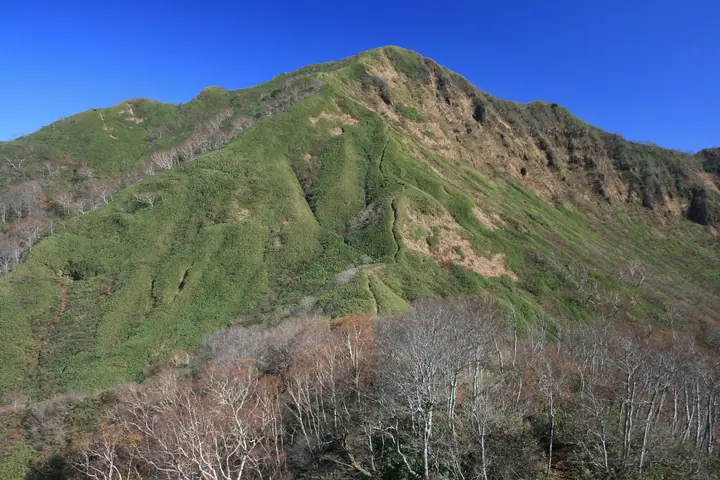
A 1,625 m stratovolcano on the boundary of Ōno City and Katsuyama City in Fukui Prefecture, lying within the special zone of Hakusan National Park and the Okuetsu Kōgen Prefectural Natural Park. A relict crater wetland known as Ike-no-Ōsawa just below the summit hosts spring blooms of skunk cabbage. The mountain's name is said to derive from a 1574 episode in which sutra ashes from the burned Heisenji temple were buried on the peak, and it is selected for the Japan 300 Famous Mountains.
Kyōgadake at a glance
- Weather: The most settled day in the next 7 days is Wed, November 4: clear, gusts up to 7 m/s. Sat, Nov 7: strong wind (gusts up to 15 m/s).
- Route: The shortest is Mount Kyogatake Return via the Hozukiyama Trail: about 5 h 44 min, 8.2 km, about 1,010 m of climbing.
Kyōgadake weather (hourly, 14 days)
Sunrise today 06:17, sunset 16:57
| Tue, 11/3 | Wed, 11/4 | Thu, 11/5 | Fri, 11/6 | Sat, 11/7 | Sun, 11/8 | Mon, 11/9 | Tue, 11/10 | Wed, 11/11 | Thu, 11/12 | Fri, 11/13 | Sat, 11/14 | Sun, 11/15 | Mon, 11/16 | Tue, 11/17 | |||||||||||||||||||||||||||||||||||||||||||||||||||||||||||||||||||||||
|---|---|---|---|---|---|---|---|---|---|---|---|---|---|---|---|---|---|---|---|---|---|---|---|---|---|---|---|---|---|---|---|---|---|---|---|---|---|---|---|---|---|---|---|---|---|---|---|---|---|---|---|---|---|---|---|---|---|---|---|---|---|---|---|---|---|---|---|---|---|---|---|---|---|---|---|---|---|---|---|---|---|---|---|---|---|
| Japan time | 15 | 17 | 19 | 21 | 23 | 1 | 3 | 5 | 7 | 9 | 11 | 13 | 15 | 18 | 21 | 0 | 3 | 6 | 9 | 12 | 15 | 18 | 21 | 0 | 3 | 6 | 9 | 12 | 15 | 18 | 21 | 0 | 3 | 6 | 9 | 12 | 15 | 18 | 21 | 0 | 3 | 6 | 9 | 12 | 15 | 18 | 21 | 0 | 3 | 6 | 9 | 15 | 21 | 3 | 9 | 15 | 21 | 3 | 9 | 15 | 21 | 3 | 9 | 15 | 21 | 3 | 9 | 15 | 21 | 3 | 9 | 15 | 21 | 3 | 9 | 15 | 21 | 3 | 9 | 15 | 21 | 3 | 9 | 15 | |
  |  | |   | | | | | |  | | |   |   | |   | | |   | | |   | | | | | |   |   | | | | |   |   | |   |   |   | | | | | | | | | | | | | | | | | | | |   | | | | | | | | | |  | | | | | | | | | | | |   | | |   | ||
| Temperature | °C | 8° | 4° | 1° | -1° | -1° | -1° | -1° | -2° | -1° | 8° | 11° | 12° | 10° | 7° | 6° | 7° | 6° | 7° | 9° | 12° | 12° | 9° | 8° | 7° | 7° | 7° | 7° | 9° | 6° | 4° | 2° | 1° | 0° | -1° | 0° | 1° | 1° | -1° | -1° | -2° | -2° | -1° | 2° | 5° | 4° | 2° | 1° | 1° | 1° | 1° | 4° | 5° | -2° | -3° | 4° | 4° | 1° | -3° | -1° | 1° | -3° | -6° | 2° | 3° | -3° | 0° | 1° | 3° | -4° | -4° | 5° | 8° | 1° | 2° | 5° | 7° | 6° | 6° | 7° | 5° | 0° | -3° | 2° | 5° |
| Precipitation | mm | 1.1 | 6 | 3.4 | 2.7 | 0.3 | 0.4 | 0.2 | 8 | 1.9 | 1.3 | 1.5 | 1.8 | 0.9 | 0.6 | 0.9 | 0.7 | 1.1 | 0.8 | 0.8 | 0.2 | 0.1 | 0.4 | 0.7 | 0.5 | 0.8 | 12 | 6 | 0.6 | 0.9 | 1.1 | 0.9 | 0.1 | 0.4 | 5.0 | 12 | 6 | 1.2 | 0.3 | ||||||||||||||||||||||||||||||||||||||||||||||
| New snow | cm | 0.1 | <.1 | 0.1 | <.1 | <.1 | <.1 | 1.2 | 0.3 | 0.2 | |||||||||||||||||||||||||||||||||||||||||||||||||||||||||||||||||||||||||||
| Snow depth | cm | 0 | 0 | 0 | 0 | 0 | 0 | 0 | 0 | 0 | 0 | 0 | 0 | 0 | 0 | 0 | 0 | 0 | 0 | 0 | 0 | 0 | 0 | 0 | 0 | 0 | 0 | 0 | 0 | 0 | 0 | 0 | 0 | 0 | 0 | 0 | <1 | <1 | 0 | 0 | 0 | 0 | 0 | 0 | 0 | 0 | 0 | 0 | 0 | 0 | 0 | 0 | 0 | 0 | 0 | 0 | 0 | 0 | <1 | <1 | <1 | <1 | <1 | <1 | <1 | <1 | <1 | <1 | 0 | 0 | 0 | 0 | 0 | 0 | 0 | 0 | 0 | 0 | 0 | 0 | 0 | 0 | 0 | 0 | 0 |
| Wind | m/s | 3 | 1 | 1 | 1 | 1 | 1 | 1 | 1 | 1 | 1 | 1 | 2 | 2 | 1 | 2 | 1 | 1 | 1 | 1 | 1 | 1 | 0 | 1 | 2 | 1 | 2 | 3 | 5 | 4 | 4 | 4 | 4 | 3 | 3 | 4 | 5 | 5 | 3 | 2 | 2 | 2 | 1 | 1 | 3 | 1 | 0 | 1 | 0 | 0 | 0 | 1 | 2 | 1 | 1 | 2 | 2 | 2 | 5 | 4 | 5 | 1 | 1 | 1 | 3 | 1 | 1 | 3 | 4 | 1 | 0 | 2 | 3 | 2 | 2 | 3 | 3 | 3 | 1 | 2 | 5 | 2 | 0 | 0 | 1 |
| Wind gusts | m/s | 9 | 8 | 4 | 3 | 4 | 4 | 3 | 4 | 3 | 3 | 6 | 6 | 7 | 6 | 7 | 6 | 8 | 6 | 4 | 5 | 6 | 5 | 4 | 5 | 7 | 8 | 9 | 14 | 15 | 13 | 12 | 13 | 13 | 12 | 12 | 15 | 15 | 14 | 10 | 9 | 9 | 9 | 7 | 9 | 10 | 5 | 3 | 3 | 4 | 4 | 6 | 10 | 6 | 5 | 8 | 12 | 10 | 19 | 18 | 17 | 14 | 6 | 4 | 9 | 9 | 6 | 10 | 13 | 12 | 5 | 6 | 9 | 8 | 6 | 9 | 10 | 11 | 10 | 7 | 16 | 16 | 9 | 4 | 6 |
| Wind dir. | ↓ | ↓ | ↓ | ↓ | ↓ | ↓ | ↓ | ↓ | ↓ | ↓ | ↓ | ↓ | ↓ | ↓ | ↓ | ↓ | ↓ | ↓ | ↓ | ↓ | ↓ | ↓ | ↓ | ↓ | ↓ | ↓ | ↓ | ↓ | ↓ | ↓ | ↓ | ↓ | ↓ | ↓ | ↓ | ↓ | ↓ | ↓ | ↓ | ↓ | ↓ | ↓ | ↓ | ↓ | ↓ | ↓ | ↓ | ↓ | ↓ | ↓ | ↓ | ↓ | ↓ | ↓ | ↓ | ↓ | ↓ | ↓ | ↓ | ↓ | ↓ | ↓ | ↓ | ↓ | ↓ | ↓ | ↓ | ↓ | ↓ | ↓ | ↓ | ↓ | ↓ | ↓ | ↓ | ↓ | ↓ | ↓ | ↓ | ↓ | ↓ | ↓ | ↓ | ↓ | |
Kyōgadake hiking routes
Hiking times are estimates calculated from the terrain.
Huts, campsites and lodging near Kyōgadake
Mountain huts
Lodging
- 奥越高原青少年自然の家
Lists that include Kyōgadake
Japan's 300 Famous Mountains · 100 Mountains of Hokuriku · Elevations of 1003 Mountains of Japan · 1000 Mountains of Japan
Kyōgadake facts
- Elevation
- 1,625 m
- Location
- Ōno-shi, Fukui
36.046419, 136.621910 - National Park
- 白山国立公園
- Website
- www.city.ono.fukui.jp
- Trail Map
- info.pref.fukui.lg.jp (PDF)
- Wikipedia
- ja.wikipedia.org