
Mt. Bessan
別山
Shirakawa, Gifu / Takayama, Gifu / Hakusan, Ishikawa · Elevation 2,399 m
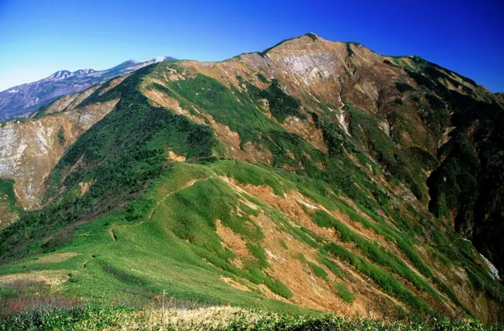
Mt. Bessan is a 2,399 m peak at the three-way junction of Hakusan in Ishikawa and Shirakawa and Takayama in Gifu Prefecture, set on the main ridge of the Hakusan Range south of the high point Mt. Gozengamine. Within Hakusan National Park, the historic Mino Zenjōdō pilgrimage trail crosses its summit, where Bessan Shrine stands just to the west. Common routes include the Bessan–Ichinose trail via the Chiburi ridge and the Nanryū-ga-Banba traverse from the Sabō-shindō. The peak is featured in Gifu Hyakuzan, Gifu Hyakushūzan, and Hida Hyakuzan.
Mt. Bessan at a glance
- Weather: The most settled day in the next 7 days is Wed, November 4: clear, gusts up to 12 m/s. Fri, Nov 6, Sat, Nov 7: strong wind (gusts up to 18 m/s).
- Route: The shortest is Mount Bessan Return from Ichinose via Chiburi Ridge and Goshariyama: about 11 h 8 min, 17.5 km, about 1,650 m of climbing.
Mt. Bessan weather (hourly, 14 days)
Sunrise today 06:17, sunset 16:56
| Tue, 11/3 | Wed, 11/4 | Thu, 11/5 | Fri, 11/6 | Sat, 11/7 | Sun, 11/8 | Mon, 11/9 | Tue, 11/10 | Wed, 11/11 | Thu, 11/12 | Fri, 11/13 | Sat, 11/14 | Sun, 11/15 | Mon, 11/16 | Tue, 11/17 | |||||||||||||||||||||||||||||||||||||||||||||||||||||||||||||||||||||||
|---|---|---|---|---|---|---|---|---|---|---|---|---|---|---|---|---|---|---|---|---|---|---|---|---|---|---|---|---|---|---|---|---|---|---|---|---|---|---|---|---|---|---|---|---|---|---|---|---|---|---|---|---|---|---|---|---|---|---|---|---|---|---|---|---|---|---|---|---|---|---|---|---|---|---|---|---|---|---|---|---|---|---|---|---|---|
| Japan time | 15 | 17 | 19 | 21 | 23 | 1 | 3 | 5 | 7 | 9 | 11 | 13 | 15 | 18 | 21 | 0 | 3 | 6 | 9 | 12 | 15 | 18 | 21 | 0 | 3 | 6 | 9 | 12 | 15 | 18 | 21 | 0 | 3 | 6 | 9 | 12 | 15 | 18 | 21 | 0 | 3 | 6 | 9 | 12 | 15 | 18 | 21 | 0 | 3 | 6 | 9 | 15 | 21 | 3 | 9 | 15 | 21 | 3 | 9 | 15 | 21 | 3 | 9 | 15 | 21 | 3 | 9 | 15 | 21 | 3 | 9 | 15 | 21 | 3 | 9 | 15 | 21 | 3 | 9 | 15 | 21 | 3 | 9 | 15 | |
  |  | | |   | | | | |  | | |   |   | |   | | |   | | | | | | | | |   | | | |   | |   |   | | | | | | | | | | |   | | | | | | | | | | | | | | | |  | | | | |   | | | | | | | |   | | | | | | | | | | ||
| Temperature | °C | 4° | 0° | -2° | -3° | -3° | -2° | -2° | -3° | -2° | 5° | 7° | 8° | 7° | 4° | 4° | 4° | 4° | 6° | 7° | 8° | 9° | 5° | 5° | 4° | 4° | 4° | 4° | 5° | 2° | 0° | -2° | -3° | -4° | -5° | -5° | -4° | -4° | -6° | -6° | -7° | -7° | -6° | -2° | 0° | -1° | -4° | -4° | -3° | -3° | -3° | 0° | 0° | -5° | -6° | 0° | 0° | -4° | -8° | -6° | -4° | -7° | -8° | -2° | -1° | -5° | -3° | -3° | -2° | -7° | -6° | 2° | 3° | -2° | -2° | 1° | 2° | 4° | 4° | 4° | 0° | -5° | -5° | 1° | 2° |
| Precipitation | mm | 1.0 | 6 | 4.7 | 3.3 | 1.0 | 0.7 | 0.6 | 7 | 2.5 | 1.4 | 1.2 | 2.2 | 1.8 | 1.1 | 1.3 | 1.2 | 1.9 | 1.5 | 1.3 | 0.7 | 0.2 | 0.4 | 0.2 | 0.6 | 0.9 | 0.8 | 0.5 | 11 | 8 | 1.8 | 1.7 | 1.2 | 3.0 | 1.3 | 6 | 10 | 7 | 5 | 1.2 | |||||||||||||||||||||||||||||||||||||||||||||
| New snow | cm | 0.2 | 0.6 | 1.7 | 1.3 | 1.2 | 0.6 | 0.2 | 0.3 | <.1 | 0.2 | <.1 | 2.3 | 7.2 | 1.8 | 1.6 | <.1 | 0.7 | |||||||||||||||||||||||||||||||||||||||||||||||||||||||||||||||||||
| Snow depth | cm | 0 | 0 | 0 | 0 | 0 | 0 | 0 | 0 | 0 | 0 | 0 | 0 | 0 | 0 | 0 | 0 | 0 | 0 | 0 | 0 | 0 | 0 | 0 | 0 | 0 | 0 | 0 | 0 | 0 | 0 | 0 | 0 | 0 | 2 | 2 | 3 | 3 | 3 | 3 | 3 | 3 | 3 | 3 | 3 | 2 | 2 | 2 | 2 | 2 | 2 | 1 | <1 | <1 | <1 | 0 | 0 | 2 | 6 | 7 | 8 | 8 | 8 | 7 | 6 | 6 | 6 | 6 | 5 | 5 | 5 | 4 | 3 | 2 | 2 | 2 | <1 | 0 | 0 | 0 | 0 | 0 | 0 | 0 | 0 |
| Wind | m/s | 2 | 1 | 1 | 1 | 1 | 1 | 1 | 0 | 0 | 1 | 2 | 2 | 3 | 1 | 1 | 1 | 1 | 1 | 0 | 1 | 2 | 0 | 1 | 1 | 2 | 3 | 3 | 4 | 3 | 3 | 3 | 3 | 3 | 3 | 3 | 3 | 3 | 3 | 3 | 2 | 3 | 2 | 2 | 2 | 1 | 1 | 1 | 0 | 0 | 1 | 2 | 1 | 1 | 1 | 3 | 3 | 3 | 4 | 6 | 5 | 2 | 0 | 0 | 2 | 0 | 2 | 4 | 4 | 2 | 0 | 1 | 2 | 1 | 1 | 3 | 2 | 3 | 2 | 2 | 5 | 3 | 2 | 1 | 1 |
| Wind gusts | m/s | 11 | 9 | 6 | 6 | 6 | 5 | 4 | 4 | 4 | 6 | 9 | 10 | 12 | 12 | 14 | 13 | 13 | 13 | 12 | 10 | 11 | 9 | 9 | 10 | 12 | 13 | 13 | 15 | 16 | 14 | 15 | 16 | 16 | 16 | 17 | 18 | 17 | 16 | 16 | 15 | 16 | 16 | 14 | 10 | 10 | 7 | 7 | 8 | 10 | 9 | 9 | 11 | 7 | 6 | 12 | 17 | 14 | 24 | 25 | 24 | 19 | 11 | 5 | 8 | 8 | 11 | 16 | 17 | 17 | 12 | 4 | 8 | 9 | 10 | 15 | 17 | 21 | 21 | 12 | 20 | 21 | 15 | 7 | 10 |
| Wind dir. | ↓ | ↓ | ↓ | ↓ | ↓ | ↓ | ↓ | ↓ | ↓ | ↓ | ↓ | ↓ | ↓ | ↓ | ↓ | ↓ | ↓ | ↓ | ↓ | ↓ | ↓ | ↓ | ↓ | ↓ | ↓ | ↓ | ↓ | ↓ | ↓ | ↓ | ↓ | ↓ | ↓ | ↓ | ↓ | ↓ | ↓ | ↓ | ↓ | ↓ | ↓ | ↓ | ↓ | ↓ | ↓ | ↓ | ↓ | ↓ | ↓ | ↓ | ↓ | ↓ | ↓ | ↓ | ↓ | ↓ | ↓ | ↓ | ↓ | ↓ | ↓ | ↓ | ↓ | ↓ | ↓ | ↓ | ↓ | ↓ | ↓ | ↓ | ↓ | ↓ | ↓ | ↓ | ↓ | ↓ | ↓ | ↓ | ↓ | ↓ | ↓ | ↓ | ↓ | ↓ | |
Mt. Bessan hiking routes
Hiking times are estimates calculated from the terrain.
Huts, campsites and lodging near Mt. Bessan
Mountain huts
- チブリ尾根避難小屋 unstaffed · sleeps 20
- 三ノ峰避難小屋 unstaffed · sleeps 25
- Jinnosuke Hinangoya unstaffed · sleeps 20
- 南竜山荘 2026: open July 1–October 15 · reservation required
- 殿ヶ池避難小屋 unstaffed · sleeps 12
Campsites
- 南竜ヶ馬場野営場
Lists that include Mt. Bessan
100 Mountains of Gifu · Elevations of 1003 Mountains of Japan · 1000 Mountains of Japan
Mt. Bessan facts
- Elevation
- 2,399 m
- Location
- Shirakawa, Gifu / Takayama, Gifu / Hakusan, Ishikawa
36.105428, 136.765720 - National Park
- 白山国立公園
- Website
- hakusan-guide.or.jp
- Trail Map
- www.pref.ishikawa.lg.jp (PDF)
- Access Information
- hakusan-guide.or.jp
- Wikipedia
- ja.wikipedia.org