
Mount Haku
白山
Hakusan, Ishikawa · Elevation 2,702 m
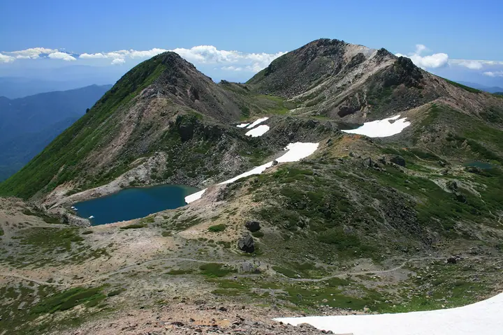
Mount Haku is a 2,702 m active volcano whose highest summit, Gozengamine, is in Hakusan City, Ishikawa. The highest mountain in the northern Ryohaku Mountains, its massif extends into Shirakawa, Gifu, within Hakusan National Park. The main route climbs from Bettodeai to Gozengamine. Heavy winter snow covers the mountain, and alpine and subalpine habitats support flowers including Hakusan cranesbill and chocolate lily.
Mount Haku at a glance
- Weather: The most settled day in the next 7 days is Wed, November 4: clear, gusts up to 13 m/s. Fri, Nov 6, Sat, Nov 7: strong wind (gusts up to 17 m/s).
- Route: The shortest is Mount Hakusan’s Gozenpo via Sabō Shindō from Bettōdeai Out-and-Back: about 9 h 21 min, 14.2 km, about 1,530 m of climbing.
Mount Haku weather (hourly, 14 days)
Sunrise today 06:17, sunset 16:56
| Tue, 11/3 | Wed, 11/4 | Thu, 11/5 | Fri, 11/6 | Sat, 11/7 | Sun, 11/8 | Mon, 11/9 | Tue, 11/10 | Wed, 11/11 | Thu, 11/12 | Fri, 11/13 | Sat, 11/14 | Sun, 11/15 | Mon, 11/16 | Tue, 11/17 | |||||||||||||||||||||||||||||||||||||||||||||||||||||||||||||||||||||||
|---|---|---|---|---|---|---|---|---|---|---|---|---|---|---|---|---|---|---|---|---|---|---|---|---|---|---|---|---|---|---|---|---|---|---|---|---|---|---|---|---|---|---|---|---|---|---|---|---|---|---|---|---|---|---|---|---|---|---|---|---|---|---|---|---|---|---|---|---|---|---|---|---|---|---|---|---|---|---|---|---|---|---|---|---|---|
| Japan time | 21 | 23 | 1 | 3 | 5 | 7 | 9 | 11 | 13 | 15 | 17 | 19 | 21 | 0 | 3 | 6 | 9 | 12 | 15 | 18 | 21 | 0 | 3 | 6 | 9 | 12 | 15 | 18 | 21 | 0 | 3 | 6 | 9 | 12 | 15 | 18 | 21 | 0 | 3 | 6 | 9 | 12 | 15 | 18 | 21 | 0 | 3 | 6 | 9 | 12 | 15 | 21 | 3 | 9 | 15 | 21 | 3 | 9 | 15 | 21 | 3 | 9 | 15 | 21 | 3 | 9 | 15 | 21 | 3 | 9 | 15 | 21 | 3 | 9 | 15 | 21 | 3 | 9 | 15 | 21 | 3 | 9 | 15 | 21 | |
  | | |  | |   | | | |   |   | | |   | | |   | |   | | | | | | |   | | | |   | |   |   | | | | | | | | | | | |   | | | |  | | | | | | | | | | | |  | | | | |   | | | | | | | | | | | | | | | | | | | ||
| Temperature | °C | -5° | -5° | -4° | -4° | -6° | -5° | 3° | 5° | 6° | 5° | 2° | 2° | 2° | 2° | 2° | 4° | 5° | 8° | 7° | 4° | 3° | 3° | 2° | 1° | 2° | 2° | -1° | -3° | -3° | -5° | -6° | -7° | -7° | -6° | -7° | -8° | -8° | -9° | -9° | -9° | -4° | -1° | -2° | -6° | -4° | -3° | -3° | -3° | 0° | 1° | -1° | -7° | -8° | -2° | -2° | -6° | -10° | -8° | -6° | -9° | -10° | -4° | -3° | -7° | -5° | -5° | -4° | -9° | -7° | 0° | 1° | -4° | -4° | -1° | 0° | 2° | 2° | 2° | -2° | -7° | -7° | -1° | 0° | -3° |
| Precipitation | mm | 2.2 | 7 | 1.2 | 0.2 | 0.2 | 1.9 | 2.2 | 12 | 2.3 | 0.9 | 1.3 | 2.4 | 1.2 | 2.2 | 1.2 | 1.4 | 1.2 | 1.5 | 1.2 | 1.3 | 0.4 | 0.2 | 0.2 | 0.2 | 0.5 | 11 | 8 | 1.8 | 1.7 | 1.2 | 3.0 | 1.3 | 6 | 10 | 7 | 5 | 1.2 | 0.8 | ||||||||||||||||||||||||||||||||||||||||||||||
| New snow | cm | <.1 | 1.1 | 1.0 | 1.3 | 1.1 | 1.2 | 0.4 | 0.2 | 0.2 | 2.3 | 7.2 | 1.8 | 1.6 | <.1 | 0.7 | |||||||||||||||||||||||||||||||||||||||||||||||||||||||||||||||||||||
| Snow depth | cm | 0 | 0 | 0 | 0 | 0 | 0 | 0 | 0 | 0 | 0 | 0 | 0 | 0 | 0 | 0 | 0 | 0 | 0 | 0 | 0 | 0 | 0 | 0 | 0 | 0 | 0 | 0 | 0 | 0 | 0 | 0 | 2 | 2 | 3 | 3 | 3 | 3 | 3 | 3 | 3 | 3 | 3 | 2 | 2 | 2 | 2 | 2 | 2 | 1 | 1 | <1 | <1 | <1 | 0 | 0 | 2 | 6 | 7 | 8 | 8 | 8 | 7 | 6 | 6 | 6 | 6 | 5 | 5 | 5 | 4 | 3 | 2 | 2 | 2 | <1 | 0 | 0 | 0 | 0 | 0 | 0 | 0 | 0 | 0 |
| Wind | m/s | 1 | 0 | 0 | 1 | 0 | 1 | 1 | 2 | 3 | 3 | 1 | 1 | 1 | 0 | 1 | 0 | 1 | 2 | 2 | 1 | 3 | 3 | 3 | 3 | 3 | 3 | 3 | 3 | 3 | 2 | 3 | 3 | 3 | 3 | 4 | 3 | 4 | 3 | 4 | 2 | 1 | 1 | 0 | 1 | 1 | 1 | 1 | 0 | 1 | 3 | 2 | 1 | 1 | 3 | 3 | 3 | 4 | 6 | 5 | 2 | 0 | 0 | 2 | 0 | 2 | 4 | 4 | 2 | 0 | 1 | 2 | 1 | 1 | 3 | 2 | 3 | 2 | 2 | 5 | 3 | 2 | 1 | 1 | 1 |
| Wind gusts | m/s | 6 | 5 | 4 | 4 | 4 | 4 | 6 | 10 | 12 | 13 | 11 | 11 | 13 | 13 | 13 | 14 | 8 | 10 | 11 | 11 | 17 | 19 | 18 | 13 | 14 | 15 | 15 | 14 | 15 | 15 | 15 | 16 | 16 | 17 | 17 | 18 | 18 | 18 | 19 | 19 | 13 | 8 | 6 | 6 | 8 | 10 | 10 | 10 | 9 | 11 | 11 | 7 | 6 | 12 | 17 | 14 | 24 | 25 | 24 | 19 | 11 | 5 | 8 | 8 | 11 | 16 | 17 | 17 | 12 | 4 | 8 | 9 | 10 | 15 | 17 | 21 | 21 | 12 | 20 | 21 | 15 | 7 | 10 | 9 |
| Wind dir. | ↓ | ↓ | ↓ | ↓ | ↓ | ↓ | ↓ | ↓ | ↓ | ↓ | ↓ | ↓ | ↓ | ↓ | ↓ | ↓ | ↓ | ↓ | ↓ | ↓ | ↓ | ↓ | ↓ | ↓ | ↓ | ↓ | ↓ | ↓ | ↓ | ↓ | ↓ | ↓ | ↓ | ↓ | ↓ | ↓ | ↓ | ↓ | ↓ | ↓ | ↓ | ↓ | ↓ | ↓ | ↓ | ↓ | ↓ | ↓ | ↓ | ↓ | ↓ | ↓ | ↓ | ↓ | ↓ | ↓ | ↓ | ↓ | ↓ | ↓ | ↓ | ↓ | ↓ | ↓ | ↓ | ↓ | ↓ | ↓ | ↓ | ↓ | ↓ | ↓ | ↓ | ↓ | ↓ | ↓ | ↓ | ↓ | ↓ | ↓ | ↓ | ↓ | ↓ | ↓ | |
Mount Haku live cameras
Mount Haku hiking routes
- Mount Hakusan’s Gozenpo via Sabō Shindō from Bettōdeai Out-and-Back 14.2 km · Ascent 1,532 m Betoh Deai Parking, Bettodeai (Bus stop) (parking)
- Mount Haku Gozengamine via Sabo and Kanko Trails Loop 15.0 km · Ascent 1,571 m Betoh Deai Parking, Bettodeai (Bus stop) (parking)
- Mount Hakusan and Gozengamine Out-and-Back via the Hirase Route 14.9 km · Ascent 1,569 m 白山・大白川登山口 (parking)
- Mount Hakusan's Gozengamine Loop via the Panorama and Sabo Trails 15.6 km · Ascent 1,555 m Bettodeai (Bus stop), Betoh Deai Parking (parking)
Hiking times are estimates calculated from the terrain.
Huts, campsites and lodging near Mount Haku
Mountain huts
- Gozenso
- Hakusanso
- Raichoso 2026: open June 25–October 11 · reservation required · sleeps 21
- Kozakuraso
- Kuroyuriso
Campsites
- 南竜ヶ馬場野営場
Lists that include Mount Haku
100 Famous Japanese Mountains · Japan 200 Famous Mountains · Japan's 300 Famous Mountains · 100 Famous Mountains of Flowers · New 100 Famous Flower Mountains · Japan's 100 Highest Mountains · 100 Famous Mountains with First-order Triangulation Points · New Japan 100 Famous Mountains · Highest Peaks by Prefecture · Illustrated Collection of Japan's Famous Mountains · 100 Famous Hot Spring Mountains · 100 Fujis of Japan · Three Holy Mountains of Japan · Tokai 100 Mountains · 100 Mountains of Hokuriku · 100 Mountains of Gifu · Elevations of 1003 Mountains of Japan · 1000 Mountains of Japan
Mount Haku facts
- Also known as
- 御前峰 · 加賀富士 · Hakusan
- Elevation
- 2,702 m
- Location
- Hakusan, Ishikawa
36.155046, 136.771465 - Volcano
- Active volcano (白山)
- Website
- www.pref.ishikawa.jp
- Trail Map
- www.pref.ishikawa.lg.jp (PDF)
- Access Information
- hakusan-guide.or.jp
- Wikipedia
- ja.wikipedia.org