
Mount Dainichi
大日ヶ岳
Gujō-shi, Gifu · Elevation 1,709 m
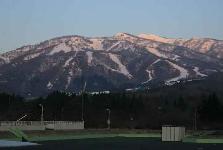
Mount Dainichi is a 1,709 m peak straddling Gujō and Takayama Cities in Gifu Prefecture, sitting at the southern end of the Ryōhakusanchi range within Hakusan National Park. The summit is said to have been opened in 717 (Yōrō 1) by the priest Taichō, who enshrined Dainichi Nyorai there, and the peak has long been a place of religious devotion. It is listed in the Nihon Nihyaku Meizan, the Shin Nihon Hyakumeizan, and the Gifu Hyakusan. Three well-graded trailheads make it a popular day climb suitable for beginners: from Hirugano-Kōgen via Ippuku-daira on the Gujō side; from the Dyna-Land ski resort in Takasu via Mae-Dainichi; and from Hinoki Pass via Suigo-yama and Kamagamine. The summit gives a sweeping view of the Hakusan range close at hand, with the Northern Alps, Mount Ontake, and Mount Norikura strung out across the northern horizon.
Mount Dainichi at a glance
- Weather: The most settled day in the next 7 days is Wed, November 4: clear, gusts up to 9 m/s.
- Route: The shortest is Mount Dainichigatake from Takasu Snow Park Gondola: about 1 h 44 min, 2.8 km, about 260 m of climbing.
Mount Dainichi weather (hourly, 14 days)
Sunrise today 06:16, sunset 16:56
| Tue, 11/3 | Wed, 11/4 | Thu, 11/5 | Fri, 11/6 | Sat, 11/7 | Sun, 11/8 | Mon, 11/9 | Tue, 11/10 | Wed, 11/11 | Thu, 11/12 | Fri, 11/13 | Sat, 11/14 | Sun, 11/15 | Mon, 11/16 | Tue, 11/17 | |||||||||||||||||||||||||||||||||||||||||||||||||||||||||||||||||||||||
|---|---|---|---|---|---|---|---|---|---|---|---|---|---|---|---|---|---|---|---|---|---|---|---|---|---|---|---|---|---|---|---|---|---|---|---|---|---|---|---|---|---|---|---|---|---|---|---|---|---|---|---|---|---|---|---|---|---|---|---|---|---|---|---|---|---|---|---|---|---|---|---|---|---|---|---|---|---|---|---|---|---|---|---|---|---|
| Japan time | 15 | 17 | 19 | 21 | 23 | 1 | 3 | 5 | 7 | 9 | 11 | 13 | 15 | 18 | 21 | 0 | 3 | 6 | 9 | 12 | 15 | 18 | 21 | 0 | 3 | 6 | 9 | 12 | 15 | 18 | 21 | 0 | 3 | 6 | 9 | 12 | 15 | 18 | 21 | 0 | 3 | 6 | 9 | 12 | 15 | 18 | 21 | 0 | 3 | 6 | 9 | 15 | 21 | 3 | 9 | 15 | 21 | 3 | 9 | 15 | 21 | 3 | 9 | 15 | 21 | 3 | 9 | 15 | 21 | 3 | 9 | 15 | 21 | 3 | 9 | 15 | 21 | 3 | 9 | 15 | 21 | 3 | 9 | 15 | |
  |  | | |   | | | | | |  | |   |   | |   | | |   | | |   | | | | |   | |   | | |   | | |   | |   |   | |   | | | | | | | | |   | | | | | | | | | |   | | |  | | | | |   | | | | | | | | | | | | | | | |   | | ||
| Temperature | °C | 8° | 3° | 0° | -1° | -1° | -1° | -1° | -2° | -1° | 6° | 10° | 10° | 9° | 6° | 6° | 7° | 6° | 6° | 7° | 10° | 11° | 7° | 7° | 6° | 6° | 6° | 7° | 9° | 6° | 3° | 1° | 0° | -1° | -1° | 0° | 1° | 0° | -3° | -3° | -3° | -3° | -3° | 1° | 5° | 3° | 0° | 0° | 0° | 0° | 0° | 3° | 5° | -2° | -3° | 2° | 3° | -1° | -4° | -2° | -1° | -4° | -6° | 2° | 4° | -4° | 0° | 0° | 2° | -4° | -5° | 3° | 5° | 1° | 1° | 3° | 5° | 5° | 5° | 7° | 4° | -2° | -3° | 3° | 4° |
| Precipitation | mm | 1.2 | 8 | 6 | 3.6 | 0.5 | 0.6 | 6 | 1.0 | 0.4 | 0.2 | 0.6 | 0.5 | 0.3 | 0.3 | 0.4 | 0.6 | 0.4 | 0.3 | 0.3 | 0.8 | 0.2 | 0.3 | 6 | 3.8 | 0.8 | 0.4 | 0.5 | 0.9 | 0.2 | 0.9 | 7 | 16 | 4.6 | 0.9 | 0.3 | |||||||||||||||||||||||||||||||||||||||||||||||||
| New snow | cm | <.1 | <.1 | 0.2 | 0.2 | 0.1 | <.1 | <.1 | <.1 | <.1 | 0.3 | 2.2 | 0.8 | 0.3 | <.1 | ||||||||||||||||||||||||||||||||||||||||||||||||||||||||||||||||||||||
| Snow depth | cm | 0 | 0 | 0 | 0 | 0 | 0 | 0 | 0 | 0 | 0 | 0 | 0 | 0 | 0 | 0 | 0 | 0 | 0 | 0 | 0 | 0 | 0 | 0 | 0 | 0 | 0 | 0 | 0 | 0 | 0 | 0 | 0 | 0 | <1 | <1 | <1 | <1 | <1 | <1 | <1 | <1 | <1 | <1 | <1 | <1 | <1 | 0 | 0 | 0 | 0 | 0 | 0 | 0 | 0 | 0 | 0 | <1 | 2 | 2 | 1 | 1 | 1 | 1 | <1 | <1 | <1 | <1 | <1 | <1 | <1 | <1 | <1 | <1 | <1 | 0 | 0 | 0 | 0 | 0 | 0 | 0 | 0 | 0 | 0 |
| Wind | m/s | 2 | 1 | 2 | 2 | 2 | 2 | 3 | 3 | 3 | 1 | 2 | 3 | 3 | 1 | 0 | 0 | 0 | 1 | 2 | 0 | 2 | 1 | 0 | 0 | 2 | 1 | 2 | 4 | 3 | 2 | 3 | 3 | 2 | 1 | 3 | 4 | 4 | 3 | 3 | 3 | 3 | 3 | 2 | 2 | 2 | 2 | 1 | 0 | 1 | 1 | 1 | 2 | 3 | 2 | 2 | 4 | 2 | 4 | 5 | 5 | 3 | 2 | 0 | 2 | 1 | 1 | 4 | 4 | 3 | 2 | 1 | 3 | 1 | 1 | 3 | 2 | 2 | 1 | 2 | 5 | 3 | 3 | 1 | 3 |
| Wind gusts | m/s | 7 | 6 | 6 | 6 | 6 | 6 | 6 | 7 | 6 | 6 | 7 | 9 | 9 | 8 | 6 | 6 | 5 | 6 | 7 | 6 | 7 | 6 | 4 | 4 | 7 | 7 | 7 | 11 | 12 | 10 | 9 | 9 | 10 | 10 | 11 | 13 | 13 | 11 | 10 | 10 | 10 | 10 | 10 | 9 | 9 | 7 | 5 | 4 | 6 | 6 | 6 | 9 | 7 | 7 | 8 | 13 | 10 | 15 | 17 | 18 | 14 | 9 | 6 | 8 | 7 | 5 | 11 | 13 | 13 | 9 | 5 | 8 | 7 | 6 | 9 | 9 | 12 | 11 | 6 | 15 | 15 | 11 | 8 | 10 |
| Wind dir. | ↓ | ↓ | ↓ | ↓ | ↓ | ↓ | ↓ | ↓ | ↓ | ↓ | ↓ | ↓ | ↓ | ↓ | ↓ | ↓ | ↓ | ↓ | ↓ | ↓ | ↓ | ↓ | ↓ | ↓ | ↓ | ↓ | ↓ | ↓ | ↓ | ↓ | ↓ | ↓ | ↓ | ↓ | ↓ | ↓ | ↓ | ↓ | ↓ | ↓ | ↓ | ↓ | ↓ | ↓ | ↓ | ↓ | ↓ | ↓ | ↓ | ↓ | ↓ | ↓ | ↓ | ↓ | ↓ | ↓ | ↓ | ↓ | ↓ | ↓ | ↓ | ↓ | ↓ | ↓ | ↓ | ↓ | ↓ | ↓ | ↓ | ↓ | ↓ | ↓ | ↓ | ↓ | ↓ | ↓ | ↓ | ↓ | ↓ | ↓ | ↓ | ↓ | ↓ | ↓ | |
Mount Dainichi hiking routes
- Mount Dainichigatake from Takasu Snow Park Gondola 2.8 km · Ascent 260 m ゴンドラ山頂駅 (Aerialway station)
- Mount Dainichigatake Return from Hirugano Kogen Trailhead 11.2 km · Ascent 822 m 大日ヶ岳登山口駐車場
- Mount Dainichigatake Out-and-Back via Mount Suigo and Mount Kamagatamine from Hino Pass 11.8 km · Ascent 1,046 m parking
Hiking times are estimates calculated from the terrain.
Huts, campsites and lodging near Mount Dainichi
Lodging
- Hotel Villa MontSaint
- ゲストハウス 西洞館
- 民宿原
- サン・ベルナール
- 大日荘
Lists that include Mount Dainichi
Japan 200 Famous Mountains · Japan's 300 Famous Mountains · New Japan 100 Famous Mountains · Tokai 100 Mountains · 100 Mountains of Gifu · Elevations of 1003 Mountains of Japan · 1000 Mountains of Japan
Mount Dainichi facts
- Elevation
- 1,709 m
- Location
- Gujō-shi, Gifu
36.001393, 136.837817 - National Park
- 白山国立公園
- Website
- gujotakasu.com
- Trail Map
- gujotakasu.com
- Wikipedia
- ja.wikipedia.org