
Mount Yokotōshi
横通岳
Azumino, Nagano / Matsumoto, Nagano · Elevation 2,767 m
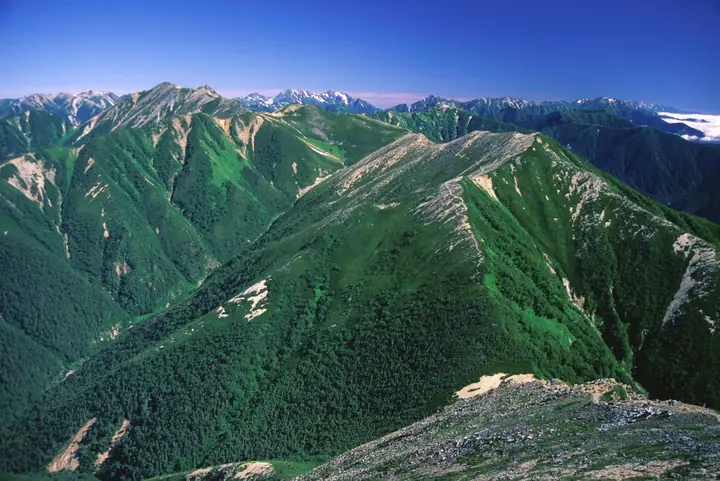
Mount Yokotōshi (2,767 m) lies in the Jōnen Range of the southern Hida Mountains (Northern Alps) on the boundary of Matsumoto and Azumino Cities, Nagano Prefecture, within the Chūbu-Sangaku National Park. Its name ("sideways pass") refers to the way the traverse from Mount Jōnen to Mount Daitenjō skirts its western slope without crossing the summit. The top is reached in about 40 minutes from the Jōnen-goya hut at Jōnen-nokkoshi pass, and offers an open view westward to Mount Yari. It is one of the One Hundred Highest Mountains of Japan.
Mount Yokotōshi at a glance
- Weather: The most settled day in the next 7 days is Wed, November 4: clear, gusts up to 7 m/s.
Mount Yokotōshi weather (hourly, 14 days)
Sunrise today 06:13, sunset 16:52
| Tue, 11/3 | Wed, 11/4 | Thu, 11/5 | Fri, 11/6 | Sat, 11/7 | Sun, 11/8 | Mon, 11/9 | Tue, 11/10 | Wed, 11/11 | Thu, 11/12 | Fri, 11/13 | Sat, 11/14 | Sun, 11/15 | Mon, 11/16 | Tue, 11/17 | |||||||||||||||||||||||||||||||||||||||||||||||||||||||||||||||||||||||
|---|---|---|---|---|---|---|---|---|---|---|---|---|---|---|---|---|---|---|---|---|---|---|---|---|---|---|---|---|---|---|---|---|---|---|---|---|---|---|---|---|---|---|---|---|---|---|---|---|---|---|---|---|---|---|---|---|---|---|---|---|---|---|---|---|---|---|---|---|---|---|---|---|---|---|---|---|---|---|---|---|---|---|---|---|---|
| Japan time | 15 | 17 | 19 | 21 | 23 | 1 | 3 | 5 | 7 | 9 | 11 | 13 | 15 | 18 | 21 | 0 | 3 | 6 | 9 | 12 | 15 | 18 | 21 | 0 | 3 | 6 | 9 | 12 | 15 | 18 | 21 | 0 | 3 | 6 | 9 | 12 | 15 | 18 | 21 | 0 | 3 | 6 | 9 | 12 | 15 | 18 | 21 | 0 | 3 | 6 | 9 | 15 | 21 | 3 | 9 | 15 | 21 | 3 | 9 | 15 | 21 | 3 | 9 | 15 | 21 | 3 | 9 | 15 | 21 | 3 | 9 | 15 | 21 | 3 | 9 | 15 | 21 | 3 | 9 | 15 | 21 | 3 | 9 | 15 | |
  |   |  | | | | | |   | |  | | |   | |   | | |   | |   |   | | | | |   | | | | |   | |   |   |   | | | | |  | | | | | | |   | | | | | | | |   | | | |   | |  | | | | | | | | | | | | | | | | | |   |   |   | | | ||
| Temperature | °C | 2° | -2° | -4° | -5° | -5° | -5° | -4° | -4° | -3° | 1° | 3° | 5° | 4° | 0° | 0° | 0° | 0° | 1° | 2° | 4° | 7° | 2° | 3° | 2° | 2° | 2° | 4° | 6° | 4° | 0° | -2° | -3° | -5° | -5° | -5° | -4° | -4° | -7° | -8° | -9° | -8° | -8° | -2° | 2° | -1° | -4° | -4° | -4° | -4° | -4° | -1° | 0° | -9° | -10° | -2° | 0° | -4° | -8° | -6° | -4° | -9° | -9° | -3° | -1° | -9° | -5° | -3° | -2° | -7° | -7° | -1° | 3° | -5° | -6° | 2° | 2° | 0° | 0° | 3° | 2° | -4° | -6° | -3° | 0° |
| Precipitation | mm | 0.2 | 2.4 | 10 | 9 | 7 | 1.1 | 0.1 | 1.0 | 1.4 | 0.3 | 0.2 | 0.3 | 0.6 | 0.7 | 0.6 | 0.3 | 0.5 | 0.7 | 0.1 | 1.4 | 4.0 | 2.3 | 0.2 | 0.4 | 0.2 | 0.6 | 9 | 11 | 1.4 | 0.5 | 0.9 | 0.5 | ||||||||||||||||||||||||||||||||||||||||||||||||||||
| New snow | cm | <.1 | <.1 | <.1 | <.1 | 0.2 | 0.5 | 0.7 | 0.6 | 0.3 | <.1 | <.1 | <.1 | <.1 | <.1 | 0.4 | 0.4 | <.1 | <.1 | <.1 | 0.7 | 2.9 | 2.2 | <.1 | 0.1 | 0.1 | <.1 | <.1 | <.1 | <.1 | <.1 | ||||||||||||||||||||||||||||||||||||||||||||||||||||||
| Snow depth | cm | 0 | 0 | 0 | 0 | 0 | 0 | 0 | 0 | 0 | 0 | 0 | 0 | 0 | 0 | 0 | 0 | 0 | 0 | 0 | 0 | 0 | 0 | 0 | 0 | 0 | 0 | 0 | 0 | 0 | 0 | 0 | <1 | <1 | <1 | 1 | 1 | <1 | <1 | <1 | <1 | <1 | <1 | <1 | <1 | <1 | <1 | <1 | <1 | <1 | <1 | <1 | <1 | <1 | <1 | <1 | <1 | 1 | 3 | 5 | 4 | 4 | 4 | 4 | 3 | 3 | 3 | 3 | 2 | 2 | 2 | 2 | 2 | 2 | 2 | 1 | 1 | <1 | <1 | <1 | <1 | <1 | <1 | <1 | <1 |
| Wind | m/s | 0 | 1 | 1 | 1 | 1 | 1 | 1 | 0 | 0 | 1 | 2 | 1 | 1 | 0 | 1 | 0 | 0 | 0 | 1 | 1 | 1 | 1 | 1 | 1 | 1 | 1 | 1 | 2 | 2 | 2 | 2 | 2 | 2 | 2 | 2 | 2 | 1 | 3 | 3 | 3 | 2 | 1 | 0 | 0 | 0 | 1 | 1 | 1 | 1 | 1 | 1 | 0 | 2 | 2 | 1 | 3 | 1 | 4 | 1 | 1 | 1 | 1 | 0 | 0 | 1 | 1 | 1 | 1 | 0 | 0 | 1 | 0 | 1 | 2 | 1 | 1 | 1 | 2 | 1 | 1 | 1 | 0 | 1 | 1 |
| Wind gusts | m/s | 6 | 5 | 6 | 7 | 7 | 6 | 5 | 4 | 4 | 6 | 7 | 7 | 7 | 6 | 6 | 6 | 5 | 5 | 8 | 10 | 9 | 7 | 7 | 8 | 8 | 8 | 9 | 11 | 11 | 11 | 11 | 12 | 12 | 13 | 13 | 13 | 12 | 12 | 13 | 12 | 11 | 10 | 9 | 6 | 6 | 7 | 7 | 8 | 9 | 9 | 9 | 8 | 6 | 7 | 7 | 14 | 12 | 20 | 21 | 12 | 7 | 5 | 6 | 6 | 7 | 8 | 8 | 8 | 7 | 5 | 5 | 6 | 6 | 7 | 8 | 10 | 11 | 12 | 11 | 11 | 9 | 5 | 5 | 7 |
| Wind dir. | ↓ | ↓ | ↓ | ↓ | ↓ | ↓ | ↓ | ↓ | ↓ | ↓ | ↓ | ↓ | ↓ | ↓ | ↓ | ↓ | ↓ | ↓ | ↓ | ↓ | ↓ | ↓ | ↓ | ↓ | ↓ | ↓ | ↓ | ↓ | ↓ | ↓ | ↓ | ↓ | ↓ | ↓ | ↓ | ↓ | ↓ | ↓ | ↓ | ↓ | ↓ | ↓ | ↓ | ↓ | ↓ | ↓ | ↓ | ↓ | ↓ | ↓ | ↓ | ↓ | ↓ | ↓ | ↓ | ↓ | ↓ | ↓ | ↓ | ↓ | ↓ | ↓ | ↓ | ↓ | ↓ | ↓ | ↓ | ↓ | ↓ | ↓ | ↓ | ↓ | ↓ | ↓ | ↓ | ↓ | ↓ | ↓ | ↓ | ↓ | ↓ | ↓ | ↓ | ↓ | |
Huts, campsites and lodging near Mount Yokotōshi
Mountain huts
- 常念小屋 2026: open April 25–November 3 · reservation required · sleeps 180
- Daitenso 2026: open June 13–November 3 · reservation required · sleeps 150
- Otenjo Hutte 2026: open July 11–October 11 · reservation required · sleeps 70
- Hutte Nishidake 2026: open July 10–October 11 · reservation required · sleeps 38
- Yarisawa Lodge 2026: open April 27–November 3 · reservation required · sleeps 100
Lists that include Mount Yokotōshi
Japan's 100 Highest Mountains · Elevations of 1003 Mountains of Japan
Mount Yokotōshi facts
- Elevation
- 2,767 m
- Location
- Azumino, Nagano / Matsumoto, Nagano
36.342637, 137.726986 - National Park
- 中部山岳国立公園
- Website
- www.mt-jonen.com
- Wikipedia
- ja.wikipedia.org