
Mount Yokote
横手山
Nakanojō, Gunma · Elevation 2,305 m
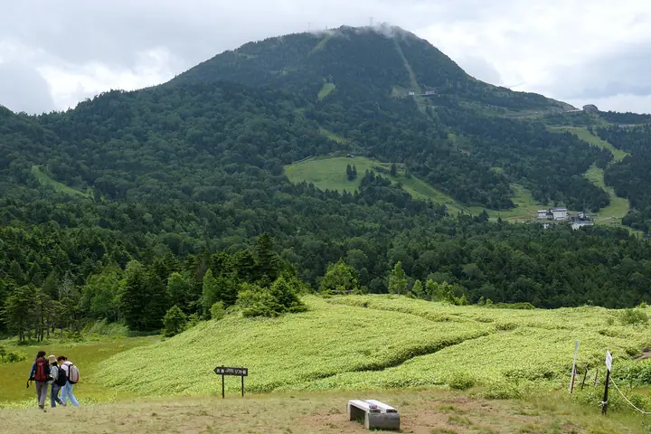
Mount Yokote is a 2305 m peak on the border between Yamanouchi Town, Nagano Prefecture, and Nakanojo Town, Gunma Prefecture. A centerpiece of Joshinetsu Kogen National Park, it is the second-highest mountain in Shiga Kogen. A Skylator and summer chairlift reach close to the summit, which is also within walking distance of Shibu Pass on Route 292 linking the two prefectures, making it popular with families. The summit has Yokote Sancho Hutte, known as Japan’s highest bakery, and the 2307 Manten View Terrace, with panoramic views toward the Northern Alps, Mount Asama and Kusatsu-Shirane. Japan’s highest ski resort, Yokoteyama-Shibutoge, operates here from November to May.
Mount Yokote at a glance
- Weather: The most settled day in the next 7 days is Wed, November 4: clear, gusts up to 8 m/s. Sat, Nov 7: strong wind (gusts up to 16 m/s).
- Route: The shortest is Mount Yokote Return from Shibu Pass: about 1 h 27 min, 2.5 km, about 160 m of climbing.
Mount Yokote weather (hourly, 14 days)
Sunrise today 06:11, sunset 16:48
| Tue, 11/3 | Wed, 11/4 | Thu, 11/5 | Fri, 11/6 | Sat, 11/7 | Sun, 11/8 | Mon, 11/9 | Tue, 11/10 | Wed, 11/11 | Thu, 11/12 | Fri, 11/13 | Sat, 11/14 | Sun, 11/15 | Mon, 11/16 | Tue, 11/17 | |||||||||||||||||||||||||||||||||||||||||||||||||||||||||||||||||||||||
|---|---|---|---|---|---|---|---|---|---|---|---|---|---|---|---|---|---|---|---|---|---|---|---|---|---|---|---|---|---|---|---|---|---|---|---|---|---|---|---|---|---|---|---|---|---|---|---|---|---|---|---|---|---|---|---|---|---|---|---|---|---|---|---|---|---|---|---|---|---|---|---|---|---|---|---|---|---|---|---|---|---|---|---|---|---|
| Japan time | 15 | 17 | 19 | 21 | 23 | 1 | 3 | 5 | 7 | 9 | 11 | 13 | 15 | 18 | 21 | 0 | 3 | 6 | 9 | 12 | 15 | 18 | 21 | 0 | 3 | 6 | 9 | 12 | 15 | 18 | 21 | 0 | 3 | 6 | 9 | 12 | 15 | 18 | 21 | 0 | 3 | 6 | 9 | 12 | 15 | 18 | 21 | 0 | 3 | 6 | 9 | 15 | 21 | 3 | 9 | 15 | 21 | 3 | 9 | 15 | 21 | 3 | 9 | 15 | 21 | 3 | 9 | 15 | 21 | 3 | 9 | 15 | 21 | 3 | 9 | 15 | 21 | 3 | 9 | 15 | 21 | 3 | 9 | 15 | |
  |   | |  | | | | |  |   | | | |   |   | | | |   |   | | | | |   |   | | | | | | | |   |   | | | | | | | | | | | | | |   | |   | | | | | | |   |   | | | | | | | | | | | | | |  | | | | |   | | | | | | | ||
| Temperature | °C | 1° | -1° | -5° | -5° | -5° | -5° | -4° | -4° | -2° | 3° | 5° | 6° | 4° | 0° | -1° | 0° | 1° | 2° | 5° | 9° | 9° | 4° | 5° | 4° | 3° | 2° | 7° | 9° | 8° | 2° | 0° | -1° | -2° | -4° | -2° | 0° | -2° | -5° | -6° | -6° | -6° | -6° | -3° | 0° | -2° | -5° | -5° | -4° | -3° | -3° | 0° | 1° | -3° | -3° | -1° | -1° | -3° | -5° | -6° | -5° | -5° | -6° | -2° | 0° | -7° | -4° | -3° | -4° | -6° | -8° | 0° | 3° | -4° | -3° | 2° | 5° | 0° | 1° | 5° | 1° | -4° | -6° | -1° | 1° |
| Precipitation | mm | 0.4 | 0.9 | 10 | 5 | 2.0 | 1.0 | 0.1 | 0.1 | 0.2 | 0.3 | 0.3 | 0.1 | 0.7 | 0.1 | 0.2 | 0.2 | 1.9 | 3.6 | 4.3 | 1.2 | 3.1 | 1.1 | 6 | 6 | 1.2 | 2.2 | ||||||||||||||||||||||||||||||||||||||||||||||||||||||||||
| New snow | cm | <.1 | <.1 | 0.1 | <.1 | 0.3 | 0.2 | 1.4 | 3.6 | 4.2 | 1.0 | 3.0 | 1.1 | 0.3 | |||||||||||||||||||||||||||||||||||||||||||||||||||||||||||||||||||||||
| Snow depth | cm | 0 | 0 | 0 | 0 | 0 | 0 | 0 | 0 | 0 | 0 | 0 | 0 | 0 | 0 | 0 | 0 | 0 | 0 | 0 | 0 | 0 | 0 | 0 | 0 | 0 | 0 | 0 | 0 | 0 | 0 | 0 | 0 | 0 | 0 | 0 | 0 | 0 | 0 | 0 | 0 | 0 | 0 | 0 | 0 | 0 | 0 | 0 | 0 | 0 | 0 | 0 | 0 | 0 | 0 | 0 | 0 | 0 | <1 | 3 | 6 | 6 | 6 | 6 | 4 | 4 | 4 | 6 | 6 | 5 | 5 | 5 | 4 | 4 | 4 | 3 | 2 | 1 | <1 | <1 | 0 | 0 | 0 | 0 | 0 |
| Wind | m/s | 2 | 2 | 1 | 1 | 1 | 0 | 1 | 1 | 0 | 1 | 2 | 2 | 2 | 2 | 2 | 2 | 1 | 1 | 0 | 0 | 0 | 1 | 0 | 1 | 1 | 1 | 2 | 4 | 4 | 2 | 2 | 3 | 3 | 3 | 3 | 5 | 4 | 3 | 2 | 2 | 3 | 3 | 3 | 3 | 3 | 1 | 1 | 1 | 1 | 1 | 1 | 1 | 1 | 0 | 2 | 1 | 0 | 5 | 6 | 6 | 2 | 2 | 1 | 0 | 0 | 2 | 2 | 4 | 2 | 2 | 0 | 0 | 0 | 1 | 0 | 1 | 0 | 2 | 2 | 5 | 4 | 3 | 1 | 1 |
| Wind gusts | m/s | 9 | 8 | 6 | 5 | 5 | 4 | 4 | 4 | 4 | 4 | 6 | 7 | 8 | 7 | 8 | 8 | 7 | 7 | 6 | 6 | 6 | 4 | 4 | 5 | 6 | 7 | 8 | 12 | 14 | 12 | 10 | 11 | 12 | 11 | 13 | 16 | 16 | 13 | 11 | 10 | 11 | 12 | 11 | 10 | 11 | 9 | 6 | 6 | 6 | 7 | 7 | 7 | 5 | 3 | 6 | 9 | 7 | 18 | 27 | 25 | 18 | 9 | 7 | 6 | 5 | 7 | 10 | 14 | 13 | 10 | 7 | 4 | 4 | 4 | 5 | 8 | 7 | 11 | 10 | 17 | 18 | 13 | 8 | 6 |
| Wind dir. | ↓ | ↓ | ↓ | ↓ | ↓ | ↓ | ↓ | ↓ | ↓ | ↓ | ↓ | ↓ | ↓ | ↓ | ↓ | ↓ | ↓ | ↓ | ↓ | ↓ | ↓ | ↓ | ↓ | ↓ | ↓ | ↓ | ↓ | ↓ | ↓ | ↓ | ↓ | ↓ | ↓ | ↓ | ↓ | ↓ | ↓ | ↓ | ↓ | ↓ | ↓ | ↓ | ↓ | ↓ | ↓ | ↓ | ↓ | ↓ | ↓ | ↓ | ↓ | ↓ | ↓ | ↓ | ↓ | ↓ | ↓ | ↓ | ↓ | ↓ | ↓ | ↓ | ↓ | ↓ | ↓ | ↓ | ↓ | ↓ | ↓ | ↓ | ↓ | ↓ | ↓ | ↓ | ↓ | ↓ | ↓ | ↓ | ↓ | ↓ | ↓ | ↓ | ↓ | ||
Mount Yokote hiking routes
Hiking times are estimates calculated from the terrain.
Huts, campsites and lodging near Mount Yokote
Mountain huts
Campsites
- 芳ヶ平野営場
- 熊の湯キャンプ場
- 木戸池キャンプ場
Lodging
- 志賀プリンス
- 熊の湯ホテル
- 湯の花旅館
- 万座温泉 日進舘
- 万座亭
Lists that include Mount Yokote
Japan's 300 Famous Mountains · Shinshu 100 Famous Mountains · Gunma 100 Famous Mountains · Elevations of 1003 Mountains of Japan · 1000 Mountains of Japan
Mount Yokote facts
- Elevation
- 2,305 m
- Location
- Nakanojō, Gunma
36.668742, 138.526118 - National Park
- 上信越高原国立公園
- Website
- visitor-center.shigakogen.gr.jp
- Access Information
- yokoteyama2307.com
- Wikipedia
- ja.wikipedia.org