
Mount Ura-Iwasuge
裏岩菅山
Yamanouchi, Nagano · Elevation 2,341 m
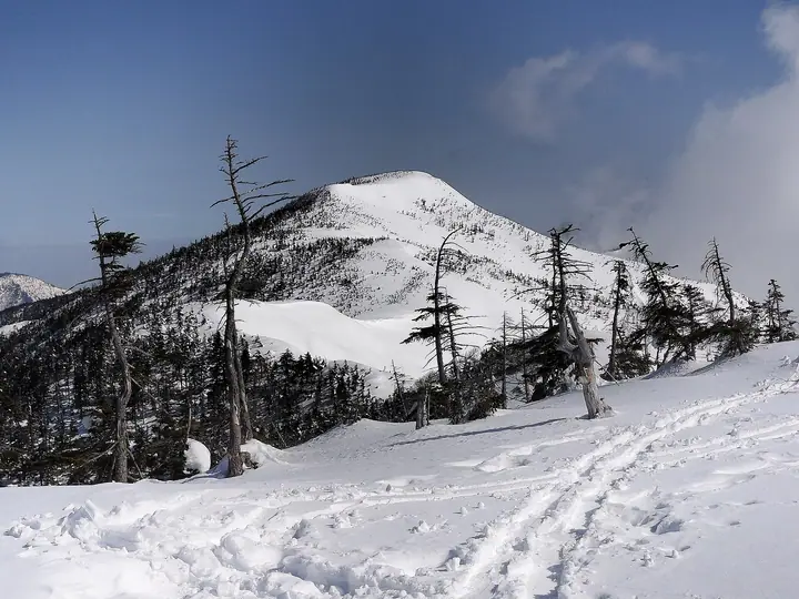
Mount Ura-Iwasuge (2,341 m) rises in Yamanouchi Town (Shimotakai District), Nagano Prefecture, immediately northeast of Mount Iwasuge (2,295 m) — and is the highest peak of the Shiga Kogen plateau. Within Joshinetsu Kogen National Park, the peak is reached by extending the main Iwasuge trekking course from East Tatedate or Hijiri-daira trailhead. Alpine flora such as shirane anemone bloom along the way, and the summit ridge gives panoramic views of the North Alps and Mount Naeba.
Mount Ura-Iwasuge at a glance
- Weather: The most settled day in the next 7 days is Wed, November 4: clear, gusts up to 8 m/s. Sat, Nov 7: strong wind (gusts up to 15 m/s).
- Route: The shortest is Shiga Kogen, over Mount Iwasuge to Ura-Iwasuge, the Plateau's Highest Peak, and Back: about 7 h 30 min, 12.2 km, about 960 m of climbing.
Mount Ura-Iwasuge weather (hourly, 14 days)
Sunrise today 06:11, sunset 16:48
| Tue, 11/3 | Wed, 11/4 | Thu, 11/5 | Fri, 11/6 | Sat, 11/7 | Sun, 11/8 | Mon, 11/9 | Tue, 11/10 | Wed, 11/11 | Thu, 11/12 | Fri, 11/13 | Sat, 11/14 | Sun, 11/15 | Mon, 11/16 | Tue, 11/17 | |||||||||||||||||||||||||||||||||||||||||||||||||||||||||||||||||||||||
|---|---|---|---|---|---|---|---|---|---|---|---|---|---|---|---|---|---|---|---|---|---|---|---|---|---|---|---|---|---|---|---|---|---|---|---|---|---|---|---|---|---|---|---|---|---|---|---|---|---|---|---|---|---|---|---|---|---|---|---|---|---|---|---|---|---|---|---|---|---|---|---|---|---|---|---|---|---|---|---|---|---|---|---|---|---|
| Japan time | 21 | 23 | 1 | 3 | 5 | 7 | 9 | 11 | 13 | 15 | 17 | 19 | 21 | 0 | 3 | 6 | 9 | 12 | 15 | 18 | 21 | 0 | 3 | 6 | 9 | 12 | 15 | 18 | 21 | 0 | 3 | 6 | 9 | 12 | 15 | 18 | 21 | 0 | 3 | 6 | 9 | 12 | 15 | 18 | 21 | 0 | 3 | 6 | 9 | 12 | 15 | 21 | 3 | 9 | 15 | 21 | 3 | 9 | 15 | 21 | 3 | 9 | 15 | 21 | 3 | 9 | 15 | 21 | 3 | 9 | 15 | 21 | 3 | 9 | 15 | 21 | 3 | 9 | 15 | 21 | 3 | 9 | 15 | 21 | |
  | |  | | |   |  | | | |   | | |   | | |   | |   | | |   | | |   | | | | |   | | |   | |   |   | | | | |   | | |   | | | | | | | | | | | | | | | | | | | | | | | | | | | |  | | | | | | | | |   | | |  | ||
| Temperature | °C | -7° | -6° | -6° | -5° | -5° | -4° | 2° | 5° | 5° | 4° | 0° | -1° | -1° | 0° | 1° | 2° | 5° | 8° | 8° | 5° | 4° | 3° | 2° | 3° | 3° | 8° | 6° | 0° | -1° | -3° | -4° | -5° | -4° | -3° | -4° | -7° | -7° | -8° | -8° | -8° | -6° | -5° | -5° | -7° | -5° | -5° | -4° | -3° | 0° | 4° | -1° | -5° | -4° | -1° | 0° | -4° | -6° | -7° | -6° | -6° | -7° | -3° | -3° | -8° | -5° | -5° | -6° | -7° | -10° | -1° | 1° | -5° | -4° | 2° | 3° | -1° | 1° | 3° | -2° | -6° | -8° | -3° | -1° | -7° |
| Precipitation | mm | 2.6 | 8 | 3.7 | 1.1 | 0.1 | 0.9 | 0.1 | 0.8 | 0.8 | 0.3 | 0.4 | 0.4 | 0.4 | 0.3 | 0.3 | 0.4 | 0.2 | 0.2 | 0.2 | 3.0 | 6 | 8 | 2.8 | 0.1 | 7 | 2.9 | 0.3 | 6 | 5 | 0.4 | 4.5 | 7 | 0.5 | |||||||||||||||||||||||||||||||||||||||||||||||||||
| New snow | cm | <.1 | <.1 | 0.2 | 0.3 | 0.2 | 0.3 | 0.2 | <.1 | <.1 | <.1 | <.1 | <.1 | <.1 | 2.6 | 5.6 | 7.7 | 2.6 | <.1 | 6.9 | 2.8 | 0.2 | <.1 | 4.5 | 0.3 | ||||||||||||||||||||||||||||||||||||||||||||||||||||||||||||
| Snow depth | cm | 0 | 0 | 0 | 0 | 0 | 0 | 0 | 0 | 0 | 0 | 0 | 0 | 0 | 0 | 0 | 0 | 0 | 0 | 0 | 0 | 0 | 0 | 0 | 0 | 0 | 0 | 0 | 0 | 0 | 0 | 0 | 0 | <1 | <1 | <1 | <1 | <1 | <1 | <1 | <1 | <1 | <1 | <1 | <1 | <1 | <1 | 1 | 1 | 1 | 1 | <1 | <1 | <1 | <1 | <1 | <1 | 2 | 6 | 11 | 12 | 11 | 11 | 10 | 9 | 9 | 14 | 15 | 15 | 15 | 15 | 13 | 12 | 12 | 12 | 9 | 9 | 7 | 6 | 3 | 5 | 6 | 6 | 5 | 5 |
| Wind | m/s | 0 | 1 | 1 | 0 | 1 | 1 | 1 | 1 | 2 | 2 | 3 | 3 | 4 | 3 | 2 | 3 | 1 | 1 | 1 | 1 | 1 | 1 | 1 | 2 | 2 | 4 | 4 | 1 | 2 | 4 | 4 | 3 | 3 | 5 | 5 | 4 | 4 | 4 | 4 | 3 | 3 | 2 | 2 | 1 | 1 | 1 | 1 | 1 | 2 | 2 | 1 | 0 | 1 | 2 | 2 | 1 | 4 | 7 | 6 | 4 | 2 | 1 | 1 | 0 | 1 | 3 | 4 | 3 | 1 | 1 | 1 | 0 | 1 | 1 | 1 | 2 | 2 | 2 | 6 | 4 | 2 | 1 | 0 | 1 |
| Wind gusts | m/s | 4 | 3 | 4 | 3 | 3 | 3 | 5 | 6 | 7 | 8 | 9 | 10 | 12 | 13 | 12 | 10 | 9 | 6 | 6 | 4 | 6 | 7 | 8 | 9 | 10 | 12 | 13 | 12 | 8 | 11 | 12 | 12 | 12 | 15 | 15 | 15 | 14 | 13 | 14 | 15 | 12 | 10 | 9 | 6 | 7 | 8 | 8 | 8 | 8 | 9 | 7 | 5 | 3 | 8 | 11 | 9 | 18 | 23 | 25 | 19 | 11 | 6 | 7 | 6 | 6 | 11 | 14 | 14 | 12 | 5 | 5 | 4 | 4 | 7 | 8 | 9 | 15 | 10 | 17 | 18 | 13 | 8 | 4 | 5 |
| Wind dir. | ↓ | ↓ | ↓ | ↓ | ↓ | ↓ | ↓ | ↓ | ↓ | ↓ | ↓ | ↓ | ↓ | ↓ | ↓ | ↓ | ↓ | ↓ | ↓ | ↓ | ↓ | ↓ | ↓ | ↓ | ↓ | ↓ | ↓ | ↓ | ↓ | ↓ | ↓ | ↓ | ↓ | ↓ | ↓ | ↓ | ↓ | ↓ | ↓ | ↓ | ↓ | ↓ | ↓ | ↓ | ↓ | ↓ | ↓ | ↓ | ↓ | ↓ | ↓ | ↓ | ↓ | ↓ | ↓ | ↓ | ↓ | ↓ | ↓ | ↓ | ↓ | ↓ | ↓ | ↓ | ↓ | ↓ | ↓ | ↓ | ↓ | ↓ | ↓ | ↓ | ↓ | ↓ | ↓ | ↓ | ↓ | ↓ | ↓ | ↓ | ↓ | ↓ | ↓ | ↓ | |
Mount Ura-Iwasuge hiking routes
Hiking times are estimates calculated from the terrain.
Huts, campsites and lodging near Mount Ura-Iwasuge
Mountain huts
Lodging
- 志賀高原プリンスホテル東館フロント
- 志賀高原プリンスホテル南館
- Okushiga Kogen Hotel
- 志賀高原プリンスホテル西館
- Hotel Grand Phenix Okushiga
Lists that include Mount Ura-Iwasuge
Shinshu Mountain Cards · Elevations of 1003 Mountains of Japan
Mount Ura-Iwasuge facts
- Elevation
- 2,341 m
- Location
- Yamanouchi, Nagano
36.752850, 138.567735 - National Park
- 上信越高原国立公園
- Website
- www.shigakogen.gr.jp
- Trail Map
- www.shigakogen.gr.jp (PDF)
- Wikipedia
- ja.wikipedia.org