
Mount Shirasuna
白砂山
Sakae, Nagano · Elevation 2,140 m
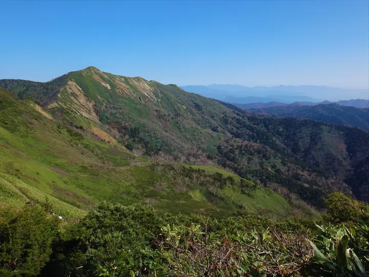
Mount Shirasuna is a 2,139.7 m peak rising at the meeting point of three prefectures—Gunma, Nagano, and Niigata—in the Mikuni Mountains, with the summit straddling Nakanojō Town, Sakae Village, and Yuzawa Town. It lies within the Jōshin'etsu-Kōgen National Park and is included in the Nihon Nihyaku Meizan, the Shinshū Hyakumeizan, the Gunma Hyakumeizan, the Kantō Hyakumeizan, and the Echigo Hyakuzan. The peak is also one of the principal summits of the Gunma Prefectural-Border Ridge Trail. The standard line ascends from Lake Nozori (~1,500 m) over Mount Dōiwa and Mount Hachiken, taking about five hours one way. The Nozoriko Hiking Information Center, run by the Nakanojō Town Tourism Association, is staffed from June through November and maintains the trail while providing current conditions.
Mount Shirasuna at a glance
- Weather: The most settled day in the next 7 days is Wed, November 4: clear, gusts up to 9 m/s. Sat, Nov 7: strong wind (gusts up to 19 m/s).
- Route: The shortest is Mount Shirasuna and Mount Hachiken Circuit from Lake Nozori: about 9 h 4 min, 14.9 km, about 1,240 m of climbing.
Mount Shirasuna weather (hourly, 14 days)
Sunrise today 06:10, sunset 16:48
| Tue, 11/3 | Wed, 11/4 | Thu, 11/5 | Fri, 11/6 | Sat, 11/7 | Sun, 11/8 | Mon, 11/9 | Tue, 11/10 | Wed, 11/11 | Thu, 11/12 | Fri, 11/13 | Sat, 11/14 | Sun, 11/15 | Mon, 11/16 | Tue, 11/17 | |||||||||||||||||||||||||||||||||||||||||||||||||||||||||||||||||||||||
|---|---|---|---|---|---|---|---|---|---|---|---|---|---|---|---|---|---|---|---|---|---|---|---|---|---|---|---|---|---|---|---|---|---|---|---|---|---|---|---|---|---|---|---|---|---|---|---|---|---|---|---|---|---|---|---|---|---|---|---|---|---|---|---|---|---|---|---|---|---|---|---|---|---|---|---|---|---|---|---|---|---|---|---|---|---|
| Japan time | 15 | 17 | 19 | 21 | 23 | 1 | 3 | 5 | 7 | 9 | 11 | 13 | 15 | 18 | 21 | 0 | 3 | 6 | 9 | 12 | 15 | 18 | 21 | 0 | 3 | 6 | 9 | 12 | 15 | 18 | 21 | 0 | 3 | 6 | 9 | 12 | 15 | 18 | 21 | 0 | 3 | 6 | 9 | 12 | 15 | 18 | 21 | 0 | 3 | 6 | 9 | 15 | 21 | 3 | 9 | 15 | 21 | 3 | 9 | 15 | 21 | 3 | 9 | 15 | 21 | 3 | 9 | 15 | 21 | 3 | 9 | 15 | 21 | 3 | 9 | 15 | 21 | 3 | 9 | 15 | 21 | 3 | 9 | 15 | |
  |   |   |   |  | | | |  |   | | | | |   | | | |   |   | | | | | |   |   | |   | | |   | |   | |   | | | | | | |   | | | | | | | | | | | |   | | | | | | | | | | | | | | | | | |  | | | | |   | | | | | | | ||
| Temperature | °C | -1° | -3° | -6° | -6° | -5° | -5° | -4° | -4° | -2° | 2° | 5° | 5° | 3° | -1° | -1° | 0° | 1° | 2° | 5° | 9° | 8° | 4° | 4° | 4° | 3° | 2° | 6° | 8° | 6° | 1° | -1° | -3° | -4° | -5° | -4° | -3° | -5° | -7° | -7° | -7° | -7° | -7° | -5° | -3° | -5° | -6° | -6° | -4° | -4° | -4° | 0° | -1° | -5° | -4° | -2° | -2° | -4° | -5° | -6° | -5° | -5° | -6° | -2° | -2° | -7° | -4° | -4° | -5° | -6° | -8° | 0° | 2° | -5° | -4° | 2° | 2° | 0° | 1° | 4° | -1° | -5° | -7° | -2° | -1° |
| Precipitation | mm | 0.6 | 0.8 | 10 | 5 | 1.4 | 1.2 | 0.2 | 0.2 | 0.2 | 0.2 | 0.6 | 0.4 | 0.2 | 0.3 | 0.2 | 0.2 | 0.5 | 0.6 | 0.1 | 0.2 | 0.2 | 0.8 | 0.5 | 0.4 | 3.4 | 5 | 7 | 2.2 | 0.2 | 7 | 2.9 | 0.5 | 6 | 5 | 0.4 | 4.7 | 7 | 0.4 | ||||||||||||||||||||||||||||||||||||||||||||||
| New snow | cm | <.1 | 0.1 | 0.1 | 0.1 | 0.2 | 0.2 | 0.2 | <.1 | <.1 | <.1 | <.1 | <.1 | 0.5 | 0.5 | 0.1 | 0.1 | <.1 | 0.1 | 3.3 | 5.0 | 7.1 | 2.0 | 0.1 | <.1 | 6.9 | 2.8 | 0.4 | <.1 | 5.7 | 0.3 | ||||||||||||||||||||||||||||||||||||||||||||||||||||||
| Snow depth | cm | 0 | 0 | 0 | 0 | 0 | 0 | 0 | 0 | 0 | 0 | 0 | 0 | 0 | 0 | 0 | 0 | 0 | 0 | 0 | 0 | 0 | 0 | 0 | 0 | 0 | 0 | 0 | 0 | 0 | 0 | 0 | 0 | <1 | <1 | <1 | <1 | <1 | <1 | <1 | <1 | <1 | <1 | <1 | <1 | <1 | <1 | <1 | <1 | 1 | 1 | 1 | <1 | <1 | <1 | <1 | <1 | <1 | 3 | 6 | 10 | 11 | 11 | 11 | 9 | 9 | 9 | 14 | 15 | 15 | 14 | 14 | 12 | 12 | 12 | 12 | 9 | 9 | 6 | 5 | 3 | 6 | 6 | 6 | 5 |
| Wind | m/s | 2 | 2 | 2 | 1 | 1 | 0 | 1 | 1 | 0 | 2 | 2 | 3 | 3 | 3 | 4 | 4 | 3 | 3 | 2 | 1 | 0 | 1 | 1 | 1 | 1 | 2 | 2 | 2 | 3 | 2 | 3 | 3 | 3 | 3 | 4 | 5 | 4 | 4 | 3 | 3 | 4 | 4 | 3 | 3 | 3 | 1 | 1 | 1 | 1 | 1 | 2 | 1 | 1 | 1 | 3 | 3 | 2 | 4 | 9 | 7 | 4 | 3 | 1 | 1 | 0 | 2 | 3 | 5 | 4 | 2 | 0 | 0 | 1 | 1 | 1 | 1 | 2 | 2 | 2 | 6 | 4 | 3 | 1 | 1 |
| Wind gusts | m/s | 10 | 9 | 7 | 6 | 5 | 4 | 4 | 4 | 4 | 5 | 7 | 8 | 9 | 10 | 12 | 13 | 12 | 11 | 10 | 8 | 7 | 4 | 5 | 6 | 6 | 7 | 7 | 9 | 10 | 10 | 10 | 11 | 12 | 12 | 15 | 18 | 19 | 15 | 14 | 12 | 14 | 14 | 14 | 11 | 11 | 10 | 7 | 6 | 6 | 7 | 7 | 7 | 6 | 5 | 8 | 10 | 10 | 16 | 29 | 28 | 22 | 12 | 8 | 7 | 6 | 7 | 11 | 15 | 15 | 12 | 8 | 4 | 5 | 5 | 6 | 7 | 9 | 14 | 10 | 18 | 19 | 14 | 10 | 4 |
| Wind dir. | ↓ | ↓ | ↓ | ↓ | ↓ | ↓ | ↓ | ↓ | ↓ | ↓ | ↓ | ↓ | ↓ | ↓ | ↓ | ↓ | ↓ | ↓ | ↓ | ↓ | ↓ | ↓ | ↓ | ↓ | ↓ | ↓ | ↓ | ↓ | ↓ | ↓ | ↓ | ↓ | ↓ | ↓ | ↓ | ↓ | ↓ | ↓ | ↓ | ↓ | ↓ | ↓ | ↓ | ↓ | ↓ | ↓ | ↓ | ↓ | ↓ | ↓ | ↓ | ↓ | ↓ | ↓ | ↓ | ↓ | ↓ | ↓ | ↓ | ↓ | ↓ | ↓ | ↓ | ↓ | ↓ | ↓ | ↓ | ↓ | ↓ | ↓ | ↓ | ↓ | ↓ | ↓ | ↓ | ↓ | ↓ | ↓ | ↓ | ↓ | ↓ | ↓ | ↓ | ↓ | |
Mount Shirasuna hiking routes
Hiking times are estimates calculated from the terrain.
Huts, campsites and lodging near Mount Shirasuna
Mountain huts
Lists that include Mount Shirasuna
Japan 200 Famous Mountains · Japan's 300 Famous Mountains · 100 Famous Hot Spring Mountains · Kanto 100 Famous Mountains · Shinshu 100 Famous Mountains · Gunma 100 Famous Mountains · Elevations of 1003 Mountains of Japan · 1000 Mountains of Japan
Mount Shirasuna facts
- Elevation
- 2,140 m
- Location
- Sakae, Nagano
36.738076, 138.693488 - National Park
- 上信越高原国立公園
- Website
- nakanojo-kanko.jp
- Trail Map
- www.gunma-trail.jp (PDF)
- Wikipedia
- ja.wikipedia.org