
Mount Naeba
苗場山
Tsunan, Niigata / Sakae, Nagano · Elevation 2,145 m
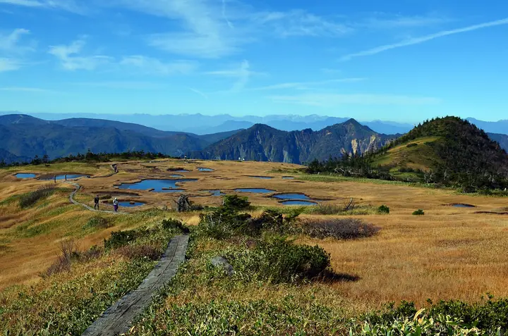
Mount Naeba is a 2,145 m peak on the border of Yuzawa and Tsunan in Niigata and Sakae in Nagano, distinguished by a roughly four-kilometer-square plateau on its summit covered in marshes and small ponds. The aquatic plants in the ponds were said to resemble rice seedlings (nae), giving the mountain its name and a long history as an object of agricultural divination. Listed in the Hyakumeizan and the 100 Mountains of Flowers, it is famous for alpine flora including Miyama-kinpōge and Watasuge. The standard routes are the Haraigawa course from Wadagoya hut on the Niigata side and the Koakasawa course from Sakae on the Nagano side, and the Naebasan summit hut (Naebasan Shizen Taiken Kōryū Center) is open from June through October.
Mount Naeba at a glance
- Weather: The most settled day in the next 7 days is Wed, November 4: clear, gusts up to 9 m/s. Sat, Nov 7: strong wind (gusts up to 20 m/s).
- Route: The shortest is Mount Naeba via the Koakasawa Trail: about 5 h 50 min, 9.4 km, about 840 m of climbing.
Mount Naeba weather (hourly, 14 days)
Sunrise today 06:10, sunset 16:47
| Tue, 11/3 | Wed, 11/4 | Thu, 11/5 | Fri, 11/6 | Sat, 11/7 | Sun, 11/8 | Mon, 11/9 | Tue, 11/10 | Wed, 11/11 | Thu, 11/12 | Fri, 11/13 | Sat, 11/14 | Sun, 11/15 | Mon, 11/16 | Tue, 11/17 | |||||||||||||||||||||||||||||||||||||||||||||||||||||||||||||||||||||||
|---|---|---|---|---|---|---|---|---|---|---|---|---|---|---|---|---|---|---|---|---|---|---|---|---|---|---|---|---|---|---|---|---|---|---|---|---|---|---|---|---|---|---|---|---|---|---|---|---|---|---|---|---|---|---|---|---|---|---|---|---|---|---|---|---|---|---|---|---|---|---|---|---|---|---|---|---|---|---|---|---|---|---|---|---|---|
| Japan time | 15 | 17 | 19 | 21 | 23 | 1 | 3 | 5 | 7 | 9 | 11 | 13 | 15 | 18 | 21 | 0 | 3 | 6 | 9 | 12 | 15 | 18 | 21 | 0 | 3 | 6 | 9 | 12 | 15 | 18 | 21 | 0 | 3 | 6 | 9 | 12 | 15 | 18 | 21 | 0 | 3 | 6 | 9 | 12 | 15 | 18 | 21 | 0 | 3 | 6 | 9 | 15 | 21 | 3 | 9 | 15 | 21 | 3 | 9 | 15 | 21 | 3 | 9 | 15 | 21 | 3 | 9 | 15 | 21 | 3 | 9 | 15 | 21 | 3 | 9 | 15 | 21 | 3 | 9 | 15 | 21 | 3 | 9 | 15 | |
  |   |   |   |  | | | |  | | | |   | |   | | | |   | |   | | | | | |   | | | | |   | | |   |   | |   | | | | |   | | | | | | | | | | | | | | | | | | | | | |   | | | | |   | | |  | | | | | | | | | | | | ||
| Temperature | °C | -2° | -4° | -7° | -6° | -6° | -6° | -6° | -5° | -3° | 2° | 4° | 5° | 4° | 0° | 0° | 0° | 1° | 1° | 4° | 8° | 8° | 4° | 3° | 2° | 2° | 1° | 4° | 4° | 4° | 0° | -2° | -4° | -5° | -6° | -6° | -6° | -7° | -7° | -8° | -8° | -8° | -7° | -6° | -5° | -6° | -7° | -7° | -6° | -6° | -6° | -2° | -4° | -6° | -6° | -1° | 0° | -4° | -6° | -6° | -6° | -6° | -6° | -4° | -4° | -8° | -5° | -6° | -6° | -7° | -9° | -2° | 0° | -7° | -6° | 3° | 2° | -1° | 0° | 2° | -1° | -6° | -8° | -5° | -3° |
| Precipitation | mm | 0.3 | 0.2 | 0.3 | 9 | 6 | 0.9 | 1.4 | 0.2 | 0.9 | 0.9 | 1.4 | 1.9 | 2.0 | 2.0 | 1.8 | 5 | 1.9 | 0.3 | 1.1 | 0.6 | 0.5 | 0.3 | 0.1 | 0.2 | 0.1 | 0.2 | 0.1 | 0.7 | 0.7 | 0.1 | 0.4 | 0.1 | 3.7 | 6 | 9 | 3.2 | 0.5 | 0.1 | 0.1 | 11 | 4.2 | 0.9 | 6 | 4.5 | 1.5 | 12 | 13 | 1.5 | ||||||||||||||||||||||||||||||||||||
| New snow | cm | <.1 | 0.1 | 0.3 | 0.2 | 1.0 | 0.5 | 0.5 | 0.2 | <.1 | 0.1 | <.1 | <.1 | <.1 | 0.1 | 0.7 | 0.7 | 0.1 | <.1 | 3.3 | 5.9 | 8.4 | 2.4 | 0.3 | <.1 | 9.2 | 3.9 | 0.8 | <.1 | <.1 | 4.8 | 0.9 | |||||||||||||||||||||||||||||||||||||||||||||||||||||
| Snow depth | cm | 0 | 0 | 0 | 0 | 0 | 0 | 0 | 0 | 0 | 0 | 0 | 0 | 0 | 0 | 0 | 0 | 0 | 0 | 0 | 0 | 0 | 0 | 0 | 0 | 0 | 0 | 0 | 0 | 0 | 0 | 0 | 0 | <1 | <1 | <1 | <1 | <1 | <1 | <1 | 2 | 2 | 2 | 2 | 2 | <1 | <1 | <1 | <1 | 2 | 2 | 2 | 1 | <1 | <1 | <1 | <1 | <1 | 3 | 6 | 11 | 12 | 12 | 11 | 9 | 9 | 9 | 15 | 17 | 17 | 16 | 16 | 13 | 13 | 12 | 12 | 9 | 7 | 4 | 3 | 1 | 4 | 5 | 5 | 4 |
| Wind | m/s | 1 | 1 | 1 | 1 | 1 | 1 | 1 | 1 | 1 | 1 | 1 | 1 | 2 | 4 | 5 | 5 | 3 | 3 | 2 | 0 | 1 | 1 | 1 | 1 | 1 | 0 | 1 | 2 | 2 | 1 | 2 | 1 | 2 | 4 | 5 | 5 | 4 | 3 | 3 | 2 | 2 | 2 | 2 | 2 | 2 | 1 | 1 | 1 | 1 | 1 | 1 | 1 | 1 | 1 | 3 | 3 | 2 | 2 | 7 | 6 | 3 | 1 | 1 | 2 | 1 | 1 | 3 | 4 | 3 | 1 | 0 | 1 | 2 | 1 | 1 | 0 | 3 | 3 | 2 | 5 | 4 | 2 | 1 | 1 |
| Wind gusts | m/s | 9 | 7 | 6 | 6 | 6 | 5 | 5 | 5 | 4 | 5 | 5 | 6 | 9 | 16 | 20 | 22 | 19 | 16 | 13 | 9 | 7 | 6 | 6 | 6 | 7 | 6 | 6 | 8 | 8 | 7 | 8 | 10 | 10 | 15 | 18 | 19 | 20 | 18 | 15 | 13 | 12 | 12 | 12 | 10 | 10 | 8 | 7 | 7 | 7 | 8 | 8 | 7 | 6 | 5 | 10 | 14 | 14 | 13 | 28 | 26 | 20 | 11 | 6 | 8 | 7 | 7 | 11 | 14 | 14 | 11 | 6 | 5 | 6 | 6 | 8 | 7 | 13 | 18 | 14 | 18 | 17 | 14 | 7 | 4 |
| Wind dir. | ↓ | ↓ | ↓ | ↓ | ↓ | ↓ | ↓ | ↓ | ↓ | ↓ | ↓ | ↓ | ↓ | ↓ | ↓ | ↓ | ↓ | ↓ | ↓ | ↓ | ↓ | ↓ | ↓ | ↓ | ↓ | ↓ | ↓ | ↓ | ↓ | ↓ | ↓ | ↓ | ↓ | ↓ | ↓ | ↓ | ↓ | ↓ | ↓ | ↓ | ↓ | ↓ | ↓ | ↓ | ↓ | ↓ | ↓ | ↓ | ↓ | ↓ | ↓ | ↓ | ↓ | ↓ | ↓ | ↓ | ↓ | ↓ | ↓ | ↓ | ↓ | ↓ | ↓ | ↓ | ↓ | ↓ | ↓ | ↓ | ↓ | ↓ | ↓ | ↓ | ↓ | ↓ | ↓ | ↓ | ↓ | ↓ | ↓ | ↓ | ↓ | ↓ | ↓ | ↓ | |
Mount Naeba hiking routes
- Mount Naeba via the Koakasawa Trail 9.4 km · Ascent 838 m 小赤沢3合目駐車場
- Mount Naeba via Haraigawa and Kaguragamine 14.7 km · Ascent 1,228 m 町営駐車場
Hiking times are estimates calculated from the terrain.
Huts, campsites and lodging near Mount Naeba
Mountain huts
Lists that include Mount Naeba
100 Famous Japanese Mountains · Japan 200 Famous Mountains · Japan's 300 Famous Mountains · 100 Famous Mountains of Flowers · 100 Famous Mountains with First-order Triangulation Points · Illustrated Collection of Japan's Famous Mountains · 100 Famous Hot Spring Mountains · Koshinetsu 100 Famous Mountains · Shinshu 100 Famous Mountains · Niigata 100 Famous Mountains · Shinshu Mountain Cards · Shin-etsu Trail · Elevations of 1003 Mountains of Japan · 1000 Mountains of Japan
Mount Naeba facts
- Elevation
- 2,145 m
- Location
- Tsunan, Niigata / Sakae, Nagano
36.845942, 138.690323 - Website
- www.town.yuzawa.lg.jp
- Trail Map
- tsunan.info (PDF)
- Access Information
- www.town.yuzawa.lg.jp
- Wikipedia
- ja.wikipedia.org