
Mount Torikabuto
鳥甲山
Sakae, Nagano · Elevation 2,038 m
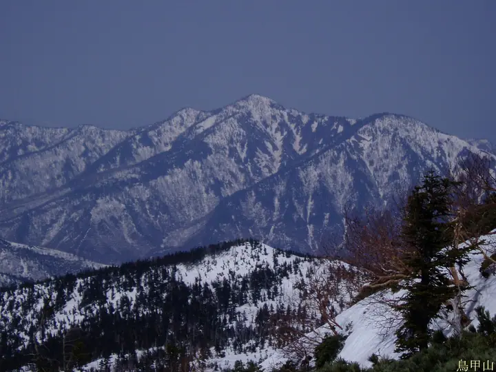
Mount Torikabuto is a 2,038 m peak rising on the western edge of the Akiyama-gō in Sakae Village, Shimominochi District, Nagano Prefecture, sitting within Jōshin'etsu Kōgen National Park as part of the Mount Naeba volcanic chain. Its sharp ridges and collapsed cliff faces give it a profile severe enough to earn the nickname "the second Tanigawa-dake," and snow lingers on its flanks well into summer. Listed in the Nihon Nihyaku Meizan and the Shinshū Hyakumeizan, the peak has only two trailheads, Yashiki and Mujina-daira, and is most often climbed as a traverse between them; the route over Shiroguraōno-kashira and Akaguraōno-kashira features a long succession of chained rock sections suited to experienced hikers. The summit views sweep across Naeba, Saburyū, and the Ura-Shiga ranges.
Mount Torikabuto at a glance
- Weather: The most settled day in the next 7 days is Wed, November 4: clear, gusts up to 5 m/s. Sat, Nov 7: strong wind (gusts up to 17 m/s).
Mount Torikabuto weather (hourly, 14 days)
Sunrise today 06:11, sunset 16:48
| Tue, 11/3 | Wed, 11/4 | Thu, 11/5 | Fri, 11/6 | Sat, 11/7 | Sun, 11/8 | Mon, 11/9 | Tue, 11/10 | Wed, 11/11 | Thu, 11/12 | Fri, 11/13 | Sat, 11/14 | Sun, 11/15 | Mon, 11/16 | Tue, 11/17 | |||||||||||||||||||||||||||||||||||||||||||||||||||||||||||||||||||||||
|---|---|---|---|---|---|---|---|---|---|---|---|---|---|---|---|---|---|---|---|---|---|---|---|---|---|---|---|---|---|---|---|---|---|---|---|---|---|---|---|---|---|---|---|---|---|---|---|---|---|---|---|---|---|---|---|---|---|---|---|---|---|---|---|---|---|---|---|---|---|---|---|---|---|---|---|---|---|---|---|---|---|---|---|---|---|
| Japan time | 15 | 17 | 19 | 21 | 23 | 1 | 3 | 5 | 7 | 9 | 11 | 13 | 15 | 18 | 21 | 0 | 3 | 6 | 9 | 12 | 15 | 18 | 21 | 0 | 3 | 6 | 9 | 12 | 15 | 18 | 21 | 0 | 3 | 6 | 9 | 12 | 15 | 18 | 21 | 0 | 3 | 6 | 9 | 12 | 15 | 18 | 21 | 0 | 3 | 6 | 9 | 15 | 21 | 3 | 9 | 15 | 21 | 3 | 9 | 15 | 21 | 3 | 9 | 15 | 21 | 3 | 9 | 15 | 21 | 3 | 9 | 15 | 21 | 3 | 9 | 15 | 21 | 3 | 9 | 15 | 21 | 3 | 9 | 15 | |
  |   | |   |  | | | |  | | |   | |   | |   | | |   | | | | | | | | |   | | | |   | | | |   |   |   | | | | |   |   | | | | | | | | | | | | | | | | | | |   | | | | | | | | | |  | | | | |   | | | | | | | ||
| Temperature | °C | 0° | -3° | -6° | -6° | -5° | -6° | -6° | -5° | -3° | 3° | 5° | 7° | 6° | 2° | 2° | 2° | 2° | 3° | 5° | 9° | 9° | 5° | 4° | 4° | 3° | 2° | 6° | 7° | 7° | 2° | 0° | -2° | -3° | -5° | -4° | -3° | -4° | -5° | -6° | -6° | -6° | -6° | -5° | -3° | -4° | -6° | -6° | -5° | -5° | -5° | 0° | -2° | -5° | -4° | 1° | 3° | -3° | -5° | -5° | -5° | -5° | -5° | -3° | -3° | -7° | -3° | -4° | -5° | -5° | -8° | -1° | 1° | -4° | -4° | 3° | 4° | -1° | 2° | 3° | 0° | -5° | -6° | -3° | -1° |
| Precipitation | mm | 0.2 | 0.2 | 8 | 6 | 1.0 | 1.4 | 0.3 | 0.7 | 0.6 | 0.7 | 0.7 | 0.3 | 0.7 | 3.9 | 0.9 | 0.2 | 0.7 | 0.4 | 0.4 | 0.2 | 0.2 | 0.1 | 0.2 | 0.9 | 0.9 | 0.1 | 0.2 | 3.7 | 7 | 10 | 3.5 | 0.3 | 10 | 3.7 | 0.7 | 6 | 4.0 | 1.8 | 11 | 13 | 1.3 | |||||||||||||||||||||||||||||||||||||||||||
| New snow | cm | <.1 | <.1 | <.1 | <.1 | 0.5 | 0.3 | 0.3 | 0.2 | <.1 | <.1 | <.1 | 0.1 | 0.2 | 0.8 | 0.7 | <.1 | <.1 | 3.1 | 6.5 | 8.4 | 2.6 | <.1 | 7.2 | 3.3 | 0.6 | <.1 | 4.6 | 0.9 | ||||||||||||||||||||||||||||||||||||||||||||||||||||||||
| Snow depth | cm | 0 | 0 | 0 | 0 | 0 | 0 | 0 | 0 | 0 | 0 | 0 | 0 | 0 | 0 | 0 | 0 | 0 | 0 | 0 | 0 | 0 | 0 | 0 | 0 | 0 | 0 | 0 | 0 | 0 | 0 | 0 | 0 | 0 | 0 | <1 | <1 | <1 | <1 | <1 | <1 | <1 | <1 | <1 | <1 | <1 | <1 | <1 | <1 | <1 | 2 | <1 | <1 | <1 | <1 | <1 | <1 | <1 | 2 | 7 | 11 | 12 | 12 | 11 | 9 | 9 | 9 | 13 | 14 | 14 | 13 | 13 | 10 | 10 | 10 | 10 | 7 | 5 | 3 | 2 | <1 | 4 | 4 | 4 | 3 |
| Wind | m/s | 1 | 1 | 1 | 1 | 1 | 1 | 1 | 1 | 1 | 0 | 1 | 1 | 1 | 3 | 4 | 3 | 2 | 2 | 2 | 1 | 1 | 0 | 0 | 1 | 0 | 0 | 1 | 2 | 2 | 1 | 0 | 1 | 1 | 3 | 5 | 5 | 4 | 3 | 2 | 2 | 2 | 1 | 1 | 2 | 1 | 2 | 2 | 2 | 1 | 2 | 1 | 1 | 1 | 2 | 2 | 3 | 1 | 3 | 5 | 5 | 3 | 0 | 1 | 1 | 1 | 1 | 2 | 3 | 2 | 0 | 0 | 1 | 1 | 1 | 1 | 0 | 2 | 3 | 2 | 3 | 3 | 1 | 0 | 1 |
| Wind gusts | m/s | 8 | 5 | 5 | 5 | 5 | 4 | 4 | 4 | 4 | 4 | 4 | 5 | 5 | 11 | 14 | 16 | 13 | 11 | 9 | 8 | 8 | 6 | 3 | 6 | 6 | 4 | 5 | 7 | 8 | 6 | 5 | 7 | 8 | 13 | 15 | 17 | 17 | 15 | 12 | 10 | 10 | 10 | 8 | 7 | 8 | 7 | 6 | 7 | 7 | 8 | 8 | 7 | 5 | 5 | 8 | 12 | 12 | 14 | 20 | 21 | 16 | 9 | 4 | 6 | 5 | 6 | 9 | 11 | 12 | 9 | 4 | 5 | 4 | 6 | 8 | 8 | 10 | 17 | 13 | 14 | 13 | 11 | 4 | 4 |
| Wind dir. | ↓ | ↓ | ↓ | ↓ | ↓ | ↓ | ↓ | ↓ | ↓ | ↓ | ↓ | ↓ | ↓ | ↓ | ↓ | ↓ | ↓ | ↓ | ↓ | ↓ | ↓ | ↓ | ↓ | ↓ | ↓ | ↓ | ↓ | ↓ | ↓ | ↓ | ↓ | ↓ | ↓ | ↓ | ↓ | ↓ | ↓ | ↓ | ↓ | ↓ | ↓ | ↓ | ↓ | ↓ | ↓ | ↓ | ↓ | ↓ | ↓ | ↓ | ↓ | ↓ | ↓ | ↓ | ↓ | ↓ | ↓ | ↓ | ↓ | ↓ | ↓ | ↓ | ↓ | ↓ | ↓ | ↓ | ↓ | ↓ | ↓ | ↓ | ↓ | ↓ | ↓ | ↓ | ↓ | ↓ | ↓ | ↓ | ↓ | ↓ | ↓ | ↓ | ↓ | ↓ | |
Huts, campsites and lodging near Mount Torikabuto
Lodging
- Kiriake Riverside House
- Akiyamago Yusenkaku
Lists that include Mount Torikabuto
Japan 200 Famous Mountains · Japan's 300 Famous Mountains · 100 Famous Hot Spring Mountains · Koshinetsu 100 Famous Mountains · Shinshu 100 Famous Mountains · Shinshu Mountain Cards · Elevations of 1003 Mountains of Japan · 1000 Mountains of Japan
Mount Torikabuto facts
- Elevation
- 2,038 m
- Location
- Sakae, Nagano
36.839176, 138.583978 - National Park
- 上信越高原国立公園
- Website
- sakae-akiyamago.com
- Trail Map
- sakae-akiyamago.com (PDF)
- Wikipedia
- ja.wikipedia.org