
Mount Iwasuge
岩菅山
Yamanouchi, Nagano · Elevation 2,295 m
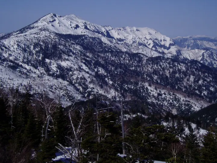
Mount Iwasuge is a 2,295 m peak in Yamanouchi Town, Shimo-Takai District, Nagano Prefecture, regarded as the master peak of the Shiga Highlands. A first-class triangulation point sits on the summit, with the higher Ura-Iwasuge (2,341 m, the highest peak of Shiga Kōgen) just to the northwest. Set in the heart of Jōshin'etsu-kōgen National Park, it appears in the Nihon Nihyaku Meizan, the Ittō-Sankakuten Hyakumeizan, the Shinshū Hyakumeizan, and the Onsen Hyakumeizan. The summit commands a sweeping panorama from Fuji and Ontake to the Northern Alps and even Sado Island in good weather, and the high ridge holds 4 km of 2,100–2,200 m terrain. The standard traverse climbs from Takamagahara or the Hoppo gondola via Higashidate-yama and Terakoya-mine to the Nokkiri junction and the summit, then descends to Ichinose Ski Resort (about 18.5 km, 6.5 hours); a shorter out-and-back from Ichinose via Kosaburo-goya-ato and Araita-zawa is also popular.
Mount Iwasuge at a glance
- Weather: The most settled day in the next 7 days is Wed, November 4: clear, gusts up to 8 m/s. Sat, Nov 7: strong wind (gusts up to 15 m/s).
- Route: The shortest is Shiga Kogen, over Mount Iwasuge to Ura-Iwasuge, the Plateau's Highest Peak, and Back: about 7 h 30 min, 12.2 km, about 960 m of climbing.
Mount Iwasuge weather (hourly, 14 days)
Sunrise today 06:11, sunset 16:48
| Tue, 11/3 | Wed, 11/4 | Thu, 11/5 | Fri, 11/6 | Sat, 11/7 | Sun, 11/8 | Mon, 11/9 | Tue, 11/10 | Wed, 11/11 | Thu, 11/12 | Fri, 11/13 | Sat, 11/14 | Sun, 11/15 | Mon, 11/16 | Tue, 11/17 | |||||||||||||||||||||||||||||||||||||||||||||||||||||||||||||||||||||||
|---|---|---|---|---|---|---|---|---|---|---|---|---|---|---|---|---|---|---|---|---|---|---|---|---|---|---|---|---|---|---|---|---|---|---|---|---|---|---|---|---|---|---|---|---|---|---|---|---|---|---|---|---|---|---|---|---|---|---|---|---|---|---|---|---|---|---|---|---|---|---|---|---|---|---|---|---|---|---|---|---|---|---|---|---|---|
| Japan time | 21 | 23 | 1 | 3 | 5 | 7 | 9 | 11 | 13 | 15 | 17 | 19 | 21 | 0 | 3 | 6 | 9 | 12 | 15 | 18 | 21 | 0 | 3 | 6 | 9 | 12 | 15 | 18 | 21 | 0 | 3 | 6 | 9 | 12 | 15 | 18 | 21 | 0 | 3 | 6 | 9 | 12 | 15 | 18 | 21 | 0 | 3 | 6 | 9 | 12 | 15 | 21 | 3 | 9 | 15 | 21 | 3 | 9 | 15 | 21 | 3 | 9 | 15 | 21 | 3 | 9 | 15 | 21 | 3 | 9 | 15 | 21 | 3 | 9 | 15 | 21 | 3 | 9 | 15 | 21 | 3 | 9 | 15 | 21 | |
  | |  | | |   |  | | | |   | | |   | | |   | |   | | |   | | |   | | | | |   | | |   | |   |   | | | | |   | | |   | | | | | | | | | | | | | | | | | | | | | | | | | | | |  | | | | | | | | |   | | |  | ||
| Temperature | °C | -6° | -6° | -6° | -5° | -5° | -3° | 2° | 5° | 6° | 5° | 0° | -1° | -1° | 0° | 1° | 3° | 6° | 8° | 8° | 5° | 4° | 4° | 2° | 3° | 4° | 8° | 7° | 1° | -1° | -3° | -4° | -5° | -4° | -2° | -4° | -7° | -7° | -7° | -8° | -8° | -6° | -4° | -5° | -7° | -4° | -5° | -3° | -3° | 1° | 4° | -1° | -5° | -4° | -1° | 0° | -4° | -6° | -7° | -6° | -6° | -6° | -3° | -2° | -8° | -5° | -5° | -6° | -6° | -10° | 0° | 1° | -5° | -4° | 2° | 3° | -1° | 2° | 3° | -1° | -6° | -7° | -3° | -1° | -6° |
| Precipitation | mm | 2.6 | 8 | 3.7 | 1.1 | 0.1 | 0.9 | 0.1 | 0.8 | 0.8 | 0.3 | 0.4 | 0.4 | 0.4 | 0.3 | 0.3 | 0.4 | 0.2 | 0.2 | 0.2 | 3.0 | 6 | 8 | 2.8 | 0.1 | 7 | 2.9 | 0.3 | 6 | 5 | 0.4 | 4.5 | 7 | 0.5 | |||||||||||||||||||||||||||||||||||||||||||||||||||
| New snow | cm | <.1 | <.1 | 0.2 | 0.3 | 0.2 | 0.3 | 0.2 | <.1 | <.1 | <.1 | <.1 | <.1 | <.1 | 2.6 | 5.6 | 7.7 | 2.6 | <.1 | 6.9 | 2.8 | 0.2 | <.1 | 4.5 | 0.3 | ||||||||||||||||||||||||||||||||||||||||||||||||||||||||||||
| Snow depth | cm | 0 | 0 | 0 | 0 | 0 | 0 | 0 | 0 | 0 | 0 | 0 | 0 | 0 | 0 | 0 | 0 | 0 | 0 | 0 | 0 | 0 | 0 | 0 | 0 | 0 | 0 | 0 | 0 | 0 | 0 | 0 | 0 | <1 | <1 | <1 | <1 | <1 | <1 | <1 | <1 | <1 | <1 | <1 | <1 | <1 | <1 | 1 | 1 | 1 | 1 | <1 | <1 | <1 | <1 | <1 | <1 | 2 | 6 | 11 | 12 | 11 | 11 | 10 | 9 | 9 | 14 | 15 | 15 | 15 | 15 | 13 | 12 | 12 | 12 | 9 | 9 | 7 | 6 | 3 | 5 | 6 | 6 | 5 | 5 |
| Wind | m/s | 0 | 1 | 1 | 0 | 1 | 1 | 1 | 1 | 2 | 2 | 3 | 3 | 4 | 3 | 2 | 3 | 1 | 1 | 1 | 1 | 1 | 1 | 1 | 2 | 2 | 4 | 4 | 1 | 2 | 4 | 4 | 3 | 3 | 5 | 5 | 4 | 4 | 4 | 4 | 3 | 3 | 2 | 2 | 1 | 1 | 1 | 1 | 1 | 2 | 2 | 1 | 0 | 1 | 2 | 2 | 1 | 4 | 7 | 6 | 4 | 2 | 1 | 1 | 0 | 1 | 3 | 4 | 3 | 1 | 1 | 1 | 0 | 1 | 1 | 1 | 2 | 2 | 2 | 6 | 4 | 2 | 1 | 0 | 1 |
| Wind gusts | m/s | 4 | 3 | 4 | 3 | 3 | 3 | 5 | 6 | 7 | 8 | 9 | 10 | 12 | 13 | 12 | 10 | 9 | 6 | 6 | 4 | 6 | 7 | 8 | 9 | 10 | 12 | 13 | 12 | 8 | 11 | 12 | 12 | 12 | 15 | 15 | 15 | 14 | 13 | 14 | 15 | 12 | 10 | 9 | 6 | 7 | 8 | 8 | 8 | 8 | 9 | 7 | 5 | 3 | 8 | 11 | 9 | 18 | 23 | 25 | 19 | 11 | 6 | 7 | 6 | 6 | 11 | 14 | 14 | 12 | 5 | 5 | 4 | 4 | 7 | 8 | 9 | 15 | 10 | 17 | 18 | 13 | 8 | 4 | 5 |
| Wind dir. | ↓ | ↓ | ↓ | ↓ | ↓ | ↓ | ↓ | ↓ | ↓ | ↓ | ↓ | ↓ | ↓ | ↓ | ↓ | ↓ | ↓ | ↓ | ↓ | ↓ | ↓ | ↓ | ↓ | ↓ | ↓ | ↓ | ↓ | ↓ | ↓ | ↓ | ↓ | ↓ | ↓ | ↓ | ↓ | ↓ | ↓ | ↓ | ↓ | ↓ | ↓ | ↓ | ↓ | ↓ | ↓ | ↓ | ↓ | ↓ | ↓ | ↓ | ↓ | ↓ | ↓ | ↓ | ↓ | ↓ | ↓ | ↓ | ↓ | ↓ | ↓ | ↓ | ↓ | ↓ | ↓ | ↓ | ↓ | ↓ | ↓ | ↓ | ↓ | ↓ | ↓ | ↓ | ↓ | ↓ | ↓ | ↓ | ↓ | ↓ | ↓ | ↓ | ↓ | ↓ | |
Mount Iwasuge hiking routes
Hiking times are estimates calculated from the terrain.
Huts, campsites and lodging near Mount Iwasuge
Mountain huts
Lodging
- 志賀高原プリンスホテル東館フロント
- 志賀高原プリンスホテル南館
- 志賀高原プリンスホテル西館
- Shiga Kogen Olympic Hotel
- Shiga Grand Hotel
Lists that include Mount Iwasuge
Japan 200 Famous Mountains · Japan's 300 Famous Mountains · 100 Famous Mountains with First-order Triangulation Points · 100 Famous Hot Spring Mountains · Koshinetsu 100 Famous Mountains · Shinshu 100 Famous Mountains · Shinshu Mountain Cards · Elevations of 1003 Mountains of Japan · 1000 Mountains of Japan
Mount Iwasuge facts
- Elevation
- 2,295 m
- Location
- Yamanouchi, Nagano
36.742057, 138.559543 - National Park
- 上信越高原国立公園
- Website
- www.shigakogen.gr.jp
- Trail Map
- www.shigakogen.gr.jp (PDF)
- Access Information
- visitor-center.shigakogen.gr.jp
- Wikipedia
- ja.wikipedia.org