
Mt. Kasagatake
笠ヶ岳
Takayama, Nagano / Yamanouchi, Nagano · Elevation 2,076 m
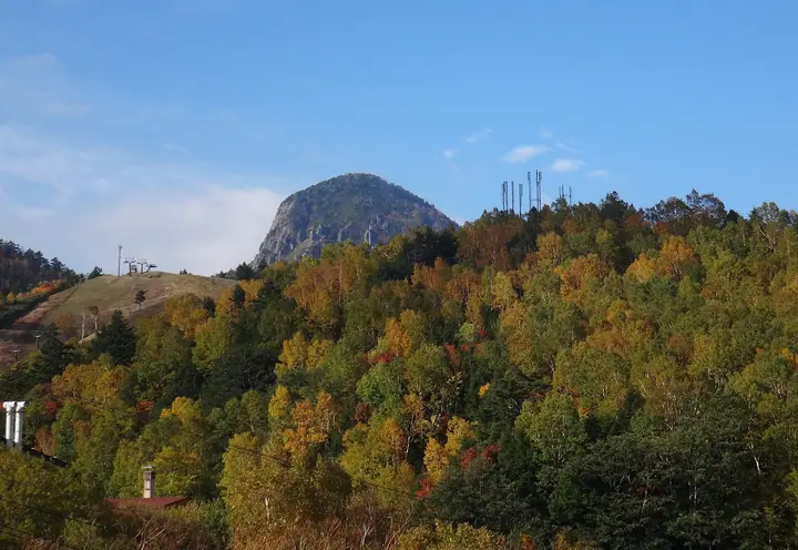
Kasagatake (2,076 m) straddles the boundary of Yamanouchi Town and Takayama Village in northern Nagano Prefecture and is among the 300 Famous Mountains of Japan and the 100 Famous Mountains of Shinshū. The peak is a lava dome of pyroxene andesite — pointed when viewed from Yokote-yama, bell-shaped from the Manza Pass side — and is one of the signature silhouettes of the Shiga Highlands. A shrine of Sano-jinja stands on the summit, which can be reached by a short 30-minute climb from Kasa-tōge pass.
Mt. Kasagatake at a glance
- Weather: The most settled day in the next 7 days is Wed, November 4: clear, gusts up to 7 m/s.
- Route: The shortest is Mount Kasa in Shiga Kogen, Summit Return from Kasadake Pass: about 48 min, 1.1 km, about 170 m of climbing.
Mt. Kasagatake weather (hourly, 14 days)
Sunrise today 06:11, sunset 16:49
| Tue, 11/3 | Wed, 11/4 | Thu, 11/5 | Fri, 11/6 | Sat, 11/7 | Sun, 11/8 | Mon, 11/9 | Tue, 11/10 | Wed, 11/11 | Thu, 11/12 | Fri, 11/13 | Sat, 11/14 | Sun, 11/15 | Mon, 11/16 | Tue, 11/17 | |||||||||||||||||||||||||||||||||||||||||||||||||||||||||||||||||||||||
|---|---|---|---|---|---|---|---|---|---|---|---|---|---|---|---|---|---|---|---|---|---|---|---|---|---|---|---|---|---|---|---|---|---|---|---|---|---|---|---|---|---|---|---|---|---|---|---|---|---|---|---|---|---|---|---|---|---|---|---|---|---|---|---|---|---|---|---|---|---|---|---|---|---|---|---|---|---|---|---|---|---|---|---|---|---|
| Japan time | 21 | 23 | 1 | 3 | 5 | 7 | 9 | 11 | 13 | 15 | 17 | 19 | 21 | 0 | 3 | 6 | 9 | 12 | 15 | 18 | 21 | 0 | 3 | 6 | 9 | 12 | 15 | 18 | 21 | 0 | 3 | 6 | 9 | 12 | 15 | 18 | 21 | 0 | 3 | 6 | 9 | 12 | 15 | 18 | 21 | 0 | 3 | 6 | 9 | 12 | 15 | 21 | 3 | 9 | 15 | 21 | 3 | 9 | 15 | 21 | 3 | 9 | 15 | 21 | 3 | 9 | 15 | 21 | 3 | 9 | 15 | 21 | 3 | 9 | 15 | 21 | 3 | 9 | 15 | 21 | 3 | 9 | 15 | 21 | |
  | | | |  |   |  | | | |   | | |   | | |   |   | | | | | | |   | | | | | | | | |   |   | | | | | | | | | |   | | | | | | | | | | | |   |   | |   | | | |  | | | | | | | | | | | | |   | | | | | | | | ||
| Temperature | °C | -4° | -4° | -3° | -3° | -3° | -1° | 4° | 6° | 7° | 7° | 3° | 2° | 1° | 2° | 2° | 3° | 6° | 10° | 10° | 7° | 6° | 6° | 4° | 4° | 6° | 10° | 9° | 4° | 2° | 0° | -1° | -2° | 0° | 1° | 0° | -3° | -4° | -4° | -5° | -5° | -2° | 0° | -1° | -4° | -3° | -3° | -2° | 0° | 2° | 6° | 3° | -2° | -2° | 1° | 4° | -2° | -3° | -6° | -4° | -4° | -5° | -1° | 1° | -6° | -3° | -3° | -3° | -5° | -7° | 0° | 4° | -3° | -1° | 4° | 6° | 1° | 3° | 5° | 2° | -4° | -5° | -1° | 2° | -4° |
| Precipitation | mm | 2.8 | 8 | 3.5 | 1.1 | 1.8 | 0.8 | 2.2 | 0.3 | 0.2 | 0.2 | 1.9 | 3.6 | 3.6 | 1.0 | 3.4 | 1.3 | 5 | 5 | 0.1 | 1.5 | 1.8 | |||||||||||||||||||||||||||||||||||||||||||||||||||||||||||||||
| New snow | cm | <.1 | 1.0 | 3.6 | 3.2 | 0.8 | 2.6 | 1.0 | 0.1 | ||||||||||||||||||||||||||||||||||||||||||||||||||||||||||||||||||||||||||||
| Snow depth | cm | 0 | 0 | 0 | 0 | 0 | 0 | 0 | 0 | 0 | 0 | 0 | 0 | 0 | 0 | 0 | 0 | 0 | 0 | 0 | 0 | 0 | 0 | 0 | 0 | 0 | 0 | 0 | 0 | 0 | 0 | 0 | 0 | 0 | 0 | 0 | 0 | 0 | 0 | 0 | 0 | 0 | 0 | 0 | 0 | 0 | 0 | 0 | 0 | 0 | 0 | 0 | 0 | 0 | 0 | 0 | 0 | <1 | 3 | 5 | 5 | 5 | 4 | 4 | 4 | 3 | 5 | 5 | 5 | 5 | 5 | 4 | 3 | 3 | 3 | 2 | 1 | <1 | <1 | 0 | 0 | 0 | 0 | 0 | 0 |
| Wind | m/s | 1 | 1 | 1 | 1 | 1 | 0 | 0 | 0 | 1 | 1 | 2 | 2 | 3 | 2 | 1 | 1 | 1 | 1 | 1 | 1 | 1 | 0 | 1 | 1 | 1 | 4 | 4 | 2 | 2 | 3 | 3 | 2 | 3 | 4 | 4 | 3 | 2 | 2 | 3 | 3 | 2 | 3 | 2 | 0 | 0 | 1 | 0 | 0 | 1 | 2 | 2 | 1 | 0 | 1 | 1 | 1 | 5 | 4 | 4 | 2 | 1 | 1 | 1 | 1 | 0 | 2 | 3 | 2 | 1 | 1 | 1 | 1 | 0 | 0 | 1 | 1 | 2 | 1 | 5 | 3 | 2 | 1 | 1 | 1 |
| Wind gusts | m/s | 3 | 3 | 3 | 3 | 3 | 3 | 4 | 5 | 6 | 7 | 6 | 7 | 8 | 8 | 8 | 7 | 5 | 5 | 5 | 4 | 7 | 6 | 7 | 5 | 6 | 14 | 15 | 12 | 8 | 9 | 9 | 9 | 9 | 13 | 13 | 13 | 9 | 8 | 10 | 11 | 9 | 9 | 9 | 7 | 4 | 6 | 6 | 6 | 6 | 8 | 8 | 7 | 3 | 6 | 10 | 8 | 18 | 20 | 20 | 16 | 8 | 4 | 6 | 5 | 5 | 9 | 13 | 12 | 8 | 5 | 4 | 4 | 4 | 5 | 8 | 7 | 12 | 9 | 16 | 16 | 11 | 6 | 6 | 5 |
| Wind dir. | ↓ | ↓ | ↓ | ↓ | ↓ | ↓ | ↓ | ↓ | ↓ | ↓ | ↓ | ↓ | ↓ | ↓ | ↓ | ↓ | ↓ | ↓ | ↓ | ↓ | ↓ | ↓ | ↓ | ↓ | ↓ | ↓ | ↓ | ↓ | ↓ | ↓ | ↓ | ↓ | ↓ | ↓ | ↓ | ↓ | ↓ | ↓ | ↓ | ↓ | ↓ | ↓ | ↓ | ↓ | ↓ | ↓ | ↓ | ↓ | ↓ | ↓ | ↓ | ↓ | ↓ | ↓ | ↓ | ↓ | ↓ | ↓ | ↓ | ↓ | ↓ | ↓ | ↓ | ↓ | ↓ | ↓ | ↓ | ↓ | ↓ | ↓ | ↓ | ↓ | ↓ | ↓ | ↓ | ↓ | ↓ | ↓ | ↓ | ↓ | ↓ | ↓ | ↓ | ↓ | |
Mt. Kasagatake hiking routes
Hiking times are estimates calculated from the terrain.
Huts, campsites and lodging near Mt. Kasagatake
Mountain huts
- 笠岳避難小屋
- 山田峠避難小屋 unstaffed
Campsites
- 熊の湯キャンプ場
- 木戸池キャンプ場
Lodging
- 熊の湯ホテル
- 志賀プリンス
- 志賀高原 癒しの宿幸の湯
- 石の湯ロッジ
- 木戸池温泉ホテル
Lists that include Mt. Kasagatake
Japan's 300 Famous Mountains · Shinshu 100 Famous Mountains · Elevations of 1003 Mountains of Japan · 1000 Mountains of Japan
Mt. Kasagatake facts
- Also known as
- 笠岳
- Elevation
- 2,076 m
- Location
- Takayama, Nagano / Yamanouchi, Nagano
36.676564, 138.481539 - Website
- www.shigakogen.gr.jp
- Wikipedia
- ja.wikipedia.org