
Mount Ōtaki
大滝山
Matsumoto, Nagano · Elevation 2,614 m
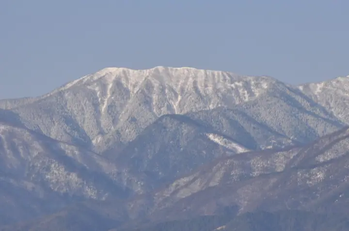
Mount Ōtaki (2,614.5 m) lies on the ridge south of Mount Chōgatake in the southern Hida Mountains (Northern Alps), straddling Matsumoto City and Azumino City in Nagano Prefecture within the Chūbu-Sangaku National Park. The peak is said to be named for the way the lingering snow on its north-east face resembles multiple waterfalls each spring. The Tokumotōge–Ōtakiyama–Chōgatake trail is designated as a national-park route; on the northern shoulder of the summit, the seasonally operated Ōtakisansō (run by the Chōgatake Hutte) provides the only on-mountain accommodation. The peak is one of the One Hundred Famous Mountains of Shinshū.
Mount Ōtaki at a glance
- Weather: The most settled day in the next 7 days is Wed, November 4: clear, gusts up to 7 m/s. Sat, Nov 7: strong wind (gusts up to 17 m/s).
Mount Ōtaki weather (hourly, 14 days)
Sunrise today 06:13, sunset 16:52
| Tue, 11/3 | Wed, 11/4 | Thu, 11/5 | Fri, 11/6 | Sat, 11/7 | Sun, 11/8 | Mon, 11/9 | Tue, 11/10 | Wed, 11/11 | Thu, 11/12 | Fri, 11/13 | Sat, 11/14 | Sun, 11/15 | Mon, 11/16 | Tue, 11/17 | |||||||||||||||||||||||||||||||||||||||||||||||||||||||||||||||||||||||
|---|---|---|---|---|---|---|---|---|---|---|---|---|---|---|---|---|---|---|---|---|---|---|---|---|---|---|---|---|---|---|---|---|---|---|---|---|---|---|---|---|---|---|---|---|---|---|---|---|---|---|---|---|---|---|---|---|---|---|---|---|---|---|---|---|---|---|---|---|---|---|---|---|---|---|---|---|---|---|---|---|---|---|---|---|---|
| Japan time | 15 | 17 | 19 | 21 | 23 | 1 | 3 | 5 | 7 | 9 | 11 | 13 | 15 | 18 | 21 | 0 | 3 | 6 | 9 | 12 | 15 | 18 | 21 | 0 | 3 | 6 | 9 | 12 | 15 | 18 | 21 | 0 | 3 | 6 | 9 | 12 | 15 | 18 | 21 | 0 | 3 | 6 | 9 | 12 | 15 | 18 | 21 | 0 | 3 | 6 | 9 | 15 | 21 | 3 | 9 | 15 | 21 | 3 | 9 | 15 | 21 | 3 | 9 | 15 | 21 | 3 | 9 | 15 | 21 | 3 | 9 | 15 | 21 | 3 | 9 | 15 | 21 | 3 | 9 | 15 | 21 | 3 | 9 | 15 | |
  |   |   | | | | | | | |  | |   |   | |   | | |   | | | | | | | |   | | | | |   | | |   |   | | | | | |  | | | | | | | |   | | | | | | |   | | | | |  | | | | | |   | | | | | | | | | | | | |   | | | | ||
| Temperature | °C | 4° | -1° | -4° | -5° | -6° | -5° | -4° | -4° | -3° | 2° | 5° | 7° | 6° | 2° | 1° | 1° | 1° | 1° | 3° | 6° | 9° | 4° | 3° | 2° | 2° | 3° | 5° | 7° | 5° | 0° | -2° | -3° | -5° | -5° | -4° | -3° | -3° | -6° | -7° | -7° | -8° | -9° | -1° | 3° | 1° | -3° | -3° | -3° | -3° | -3° | 0° | 2° | -7° | -9° | 0° | 1° | -3° | -8° | -5° | -2° | -9° | -9° | -1° | 1° | -8° | -4° | -2° | -1° | -7° | -6° | 0° | 5° | -6° | -5° | 3° | 3° | 1° | 1° | 4° | 4° | -2° | -5° | -2° | 1° |
| Precipitation | mm | 2.6 | 9 | 7 | 5 | 0.8 | 0.9 | 1.2 | 0.1 | 0.1 | 0.3 | 0.4 | 0.4 | 0.2 | 0.1 | 0.1 | 1.5 | 3.2 | 1.3 | 0.1 | 0.2 | 0.3 | 0.1 | 0.4 | 8 | 10 | 0.9 | 0.2 | 0.4 | 0.3 | |||||||||||||||||||||||||||||||||||||||||||||||||||||||
| New snow | cm | <.1 | 0.3 | 0.4 | 0.4 | 0.1 | <.1 | <.1 | <.1 | <.1 | <.1 | <.1 | 0.2 | 2.6 | 1.3 | <.1 | <.1 | <.1 | <.1 | ||||||||||||||||||||||||||||||||||||||||||||||||||||||||||||||||||
| Snow depth | cm | 0 | 0 | 0 | 0 | 0 | 0 | 0 | 0 | 0 | 0 | 0 | 0 | 0 | 0 | 0 | 0 | 0 | 0 | 0 | 0 | 0 | 0 | 0 | 0 | 0 | 0 | 0 | 0 | 0 | 0 | 0 | 0 | <1 | <1 | <1 | <1 | <1 | <1 | <1 | <1 | <1 | <1 | <1 | <1 | <1 | <1 | <1 | <1 | <1 | <1 | <1 | <1 | <1 | <1 | <1 | <1 | <1 | 2 | 2 | 2 | 2 | 2 | 2 | 1 | 1 | 1 | 1 | <1 | <1 | <1 | <1 | <1 | <1 | <1 | <1 | <1 | <1 | <1 | <1 | 0 | 0 | 0 | 0 | 0 |
| Wind | m/s | 1 | 1 | 2 | 2 | 2 | 1 | 1 | 1 | 1 | 1 | 2 | 2 | 1 | 0 | 1 | 0 | 1 | 0 | 1 | 1 | 1 | 1 | 2 | 2 | 2 | 1 | 2 | 3 | 3 | 3 | 3 | 3 | 3 | 3 | 3 | 4 | 3 | 3 | 3 | 3 | 2 | 1 | 0 | 0 | 1 | 1 | 1 | 2 | 2 | 2 | 2 | 1 | 2 | 2 | 1 | 4 | 2 | 6 | 1 | 0 | 0 | 1 | 0 | 1 | 1 | 2 | 0 | 1 | 0 | 1 | 1 | 0 | 2 | 3 | 1 | 1 | 2 | 2 | 1 | 2 | 0 | 0 | 1 | 1 |
| Wind gusts | m/s | 5 | 5 | 7 | 7 | 7 | 7 | 6 | 5 | 4 | 4 | 6 | 7 | 7 | 6 | 5 | 4 | 5 | 5 | 7 | 8 | 7 | 7 | 8 | 9 | 9 | 8 | 11 | 14 | 14 | 14 | 14 | 15 | 16 | 16 | 15 | 17 | 17 | 14 | 13 | 12 | 11 | 9 | 8 | 5 | 5 | 6 | 6 | 8 | 10 | 10 | 9 | 11 | 6 | 8 | 8 | 14 | 13 | 23 | 23 | 9 | 5 | 5 | 6 | 8 | 6 | 10 | 9 | 6 | 6 | 4 | 5 | 5 | 7 | 10 | 10 | 13 | 11 | 14 | 12 | 12 | 9 | 4 | 4 | 6 |
| Wind dir. | ↓ | ↓ | ↓ | ↓ | ↓ | ↓ | ↓ | ↓ | ↓ | ↓ | ↓ | ↓ | ↓ | ↓ | ↓ | ↓ | ↓ | ↓ | ↓ | ↓ | ↓ | ↓ | ↓ | ↓ | ↓ | ↓ | ↓ | ↓ | ↓ | ↓ | ↓ | ↓ | ↓ | ↓ | ↓ | ↓ | ↓ | ↓ | ↓ | ↓ | ↓ | ↓ | ↓ | ↓ | ↓ | ↓ | ↓ | ↓ | ↓ | ↓ | ↓ | ↓ | ↓ | ↓ | ↓ | ↓ | ↓ | ↓ | ↓ | ↓ | ↓ | ↓ | ↓ | ↓ | ↓ | ↓ | ↓ | ↓ | ↓ | ↓ | ↓ | ↓ | ↓ | ↓ | ↓ | ↓ | ↓ | ↓ | ↓ | ↓ | ↓ | ↓ | ↓ | ↓ | |
Huts, campsites and lodging near Mount Ōtaki
Mountain huts
- 大滝小屋
- 大滝山荘 2026: open July 20–August 31 · reservation required · sleeps 20
- Chogatake Hut 2026: open April 25–November 3 · reservation required · sleeps 150
- Yokoosanso 2026: open April 27–November 3 · reservation required · sleeps 150
- 横尾避難小屋 unstaffed
Campsites
- 蝶ヶ岳ヒュッテ テントサイト
- Yokoo Campground
- Tokusawa Camping Ground
Lists that include Mount Ōtaki
Shinshu 100 Famous Mountains · Elevations of 1003 Mountains of Japan
Mount Ōtaki facts
- Also known as
- 大嶽 · 崩岳 · 手水嶽
- Elevation
- 2,614 m
- Location
- Matsumoto, Nagano
36.272001, 137.741121 - National Park
- 中部山岳国立公園
- Website
- chougatake.com
- Trail Map
- chougatake.com
- Wikipedia
- ja.wikipedia.org