
Mount Kumazawa
熊沢岳
Komagane, Nagano / Okuwa, Nagano · Elevation 2,778 m
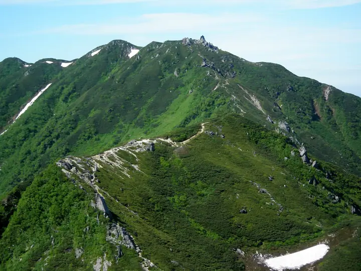
Mount Kumazawa (2,778 m) stands on the main ridge of the Chūō Alps between Mount Hinokio and Mount Utsugi, on the boundary of Komagane City and Ōkuwa Village in Nagano Prefecture, within Chūō-Alps Quasi-National Park. A granite block crowns the summit and offers wide views; the eastern flank holds the Ikenodaira cirque, where dwarf pine gives way to alpine flora. The peak is a normal waypoint on the long Utsugi–Higashikawa–Kumazawa–Hinokio traverse and is included in the One Hundred Highest Mountains of Japan.
Mount Kumazawa at a glance
- Weather: The most settled day in the next 7 days is Sun, November 8: clear, gusts up to 8 m/s.
- Route: The shortest is Central Alps: Senjojiki to Utsugidake Traverse: about 11 h 33 min, 19.1 km, about 1,220 m of climbing.
Mount Kumazawa weather (hourly, 14 days)
Sunrise today 06:12, sunset 16:53
| Tue, 11/3 | Wed, 11/4 | Thu, 11/5 | Fri, 11/6 | Sat, 11/7 | Sun, 11/8 | Mon, 11/9 | Tue, 11/10 | Wed, 11/11 | Thu, 11/12 | Fri, 11/13 | Sat, 11/14 | Sun, 11/15 | Mon, 11/16 | Tue, 11/17 | |||||||||||||||||||||||||||||||||||||||||||||||||||||||||||||||||||||||
|---|---|---|---|---|---|---|---|---|---|---|---|---|---|---|---|---|---|---|---|---|---|---|---|---|---|---|---|---|---|---|---|---|---|---|---|---|---|---|---|---|---|---|---|---|---|---|---|---|---|---|---|---|---|---|---|---|---|---|---|---|---|---|---|---|---|---|---|---|---|---|---|---|---|---|---|---|---|---|---|---|---|---|---|---|---|
| Japan time | 21 | 23 | 1 | 3 | 5 | 7 | 9 | 11 | 13 | 15 | 17 | 19 | 21 | 0 | 3 | 6 | 9 | 12 | 15 | 18 | 21 | 0 | 3 | 6 | 9 | 12 | 15 | 18 | 21 | 0 | 3 | 6 | 9 | 12 | 15 | 18 | 21 | 0 | 3 | 6 | 9 | 12 | 15 | 18 | 21 | 0 | 3 | 6 | 9 | 12 | 15 | 21 | 3 | 9 | 15 | 21 | 3 | 9 | 15 | 21 | 3 | 9 | 15 | 21 | 3 | 9 | 15 | 21 | 3 | 9 | 15 | 21 | 3 | 9 | 15 | 21 | 3 | 9 | 15 | 21 | 3 | 9 | 15 | 21 | |
  | | | | |   | | |   | |   | | |   | | |   |   |   | | |   | | | | | | | |   | | | | |  |  | | | | | | | | | | | | | | | | | | | | |   |   | |   |  | | | | | | | | | | | | | | | | | |   | | | | | | ||
| Temperature | °C | -2° | -3° | -2° | -3° | -3° | -2° | 2° | 6° | 8° | 6° | 3° | 2° | 2° | 1° | 1° | 1° | 5° | 9° | 8° | 4° | 3° | 2° | 2° | 2° | 5° | 8° | 6° | 0° | -2° | -3° | -3° | -5° | -1° | 1° | -1° | -7° | -9° | -10° | -10° | -9° | -1° | 5° | 4° | -2° | -4° | -2° | -1° | -1° | 1° | 6° | 5° | -3° | -5° | 1° | 1° | -3° | -6° | -5° | 0° | -8° | -9° | 0° | 2° | -6° | -6° | -1° | 2° | -7° | -9° | -1° | 3° | -4° | -3° | 2° | 3° | 1° | 1° | 5° | 5° | -4° | -5° | 0° | 2° | -1° |
| Precipitation | mm | 4.9 | 8 | 2.9 | 0.8 | 0.1 | 0.5 | 4.6 | 2.5 | 0.5 | 0.5 | 0.7 | 0.6 | 0.6 | 0.2 | 0.2 | 19 | 14 | 0.8 | 1.3 | 0.4 | ||||||||||||||||||||||||||||||||||||||||||||||||||||||||||||||||
| New snow | cm | <.1 | <.1 | ||||||||||||||||||||||||||||||||||||||||||||||||||||||||||||||||||||||||||||||||||
| Snow depth | cm | 0 | 0 | 0 | 0 | 0 | 0 | 0 | 0 | 0 | 0 | 0 | 0 | 0 | 0 | 0 | 0 | 0 | 0 | 0 | 0 | 0 | 0 | 0 | 0 | 0 | 0 | 0 | 0 | 0 | 0 | 0 | 0 | 0 | 0 | 0 | 0 | 0 | 0 | 0 | 0 | 0 | 0 | 0 | 0 | 0 | 0 | 0 | 0 | 0 | 0 | 0 | 0 | 0 | 0 | 0 | 0 | 0 | 0 | 0 | 0 | 0 | 0 | 0 | 0 | 0 | 0 | 0 | 0 | 0 | 0 | 0 | 0 | 0 | 0 | 0 | 0 | 0 | 0 | 0 | 0 | 0 | 0 | 0 | 0 |
| Wind | m/s | 0 | 0 | 0 | 0 | 1 | 1 | 1 | 1 | 1 | 1 | 0 | 1 | 1 | 2 | 1 | 1 | 0 | 1 | 1 | 1 | 1 | 2 | 2 | 1 | 1 | 1 | 2 | 1 | 1 | 2 | 2 | 2 | 1 | 2 | 2 | 2 | 2 | 2 | 1 | 1 | 1 | 1 | 1 | 0 | 0 | 1 | 1 | 1 | 1 | 1 | 2 | 0 | 0 | 2 | 2 | 1 | 1 | 3 | 2 | 1 | 0 | 2 | 1 | 1 | 1 | 2 | 2 | 1 | 1 | 1 | 1 | 1 | 1 | 2 | 2 | 1 | 1 | 1 | 2 | 1 | 1 | 0 | 2 | 1 |
| Wind gusts | m/s | 4 | 5 | 5 | 5 | 5 | 6 | 6 | 6 | 8 | 8 | 7 | 5 | 6 | 8 | 12 | 9 | 7 | 8 | 8 | 8 | 11 | 12 | 15 | 13 | 8 | 9 | 10 | 9 | 9 | 9 | 9 | 9 | 10 | 11 | 12 | 11 | 10 | 10 | 9 | 9 | 7 | 7 | 8 | 6 | 8 | 10 | 10 | 10 | 10 | 10 | 9 | 5 | 6 | 10 | 15 | 11 | 12 | 16 | 16 | 10 | 8 | 10 | 12 | 7 | 5 | 11 | 10 | 9 | 7 | 5 | 8 | 6 | 8 | 12 | 14 | 15 | 15 | 10 | 12 | 11 | 8 | 6 | 11 | 9 |
| Wind dir. | ↓ | ↓ | ↓ | ↓ | ↓ | ↓ | ↓ | ↓ | ↓ | ↓ | ↓ | ↓ | ↓ | ↓ | ↓ | ↓ | ↓ | ↓ | ↓ | ↓ | ↓ | ↓ | ↓ | ↓ | ↓ | ↓ | ↓ | ↓ | ↓ | ↓ | ↓ | ↓ | ↓ | ↓ | ↓ | ↓ | ↓ | ↓ | ↓ | ↓ | ↓ | ↓ | ↓ | ↓ | ↓ | ↓ | ↓ | ↓ | ↓ | ↓ | ↓ | ↓ | ↓ | ↓ | ↓ | ↓ | ↓ | ↓ | ↓ | ↓ | ↓ | ↓ | ↓ | ↓ | ↓ | ↓ | ↓ | ↓ | ↓ | ↓ | ↓ | ↓ | ↓ | ↓ | ↓ | ↓ | ↓ | ↓ | ↓ | ↓ | ↓ | ↓ | ↓ | ↓ | |
Mount Kumazawa hiking routes
Hiking times are estimates calculated from the terrain.
Huts, campsites and lodging near Mount Kumazawa
Mountain huts
- Hinokio Hut 2026: open July 11–October 12 · reservation required · sleeps 23
- Kisodono Sansou 2026: open July 1–October 11 · reservation required · sleeps 80
- Komaho Hutte 2026: open July 11–October 12 · reservation required · sleeps 25
- Utsugidaira Shelter Hut unstaffed
- 摺鉢窪避難小屋 temporarily closed
Campsites
- 檜尾小屋テント場
Lodging
- Hotel Senjojiki
Lists that include Mount Kumazawa
Japan's 100 Highest Mountains · Elevations of 1003 Mountains of Japan
Mount Kumazawa facts
- Elevation
- 2,778 m
- Location
- Komagane, Nagano / Okuwa, Nagano
35.739302, 137.803332 - National Park
- 中央アルプス国定公園
- Website
- www.kankou-komagane.com
- Wikipedia
- ja.wikipedia.org