
Mt. Nakadake
中岳
Miyada, Nagano / Agematsu, Nagano · Elevation 2,925 m
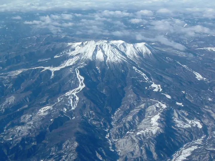
Nakadake is a 2,925 m peak forming part of the summit zone of the active volcano Mt. Ontake, set north of the highest point Kengamine and straddling Kiso Town and Ōtaki Village in Nagano Prefecture. The summit area remains under entry regulation at Volcanic Alert Level 1 since the 2014 eruption, and climbers must submit a climbing plan and carry a helmet. On 10 April 2026 the wider Ontake massif was newly designated as Ontake-san Quasi-National Park to protect its caldera and crater-lake landforms, alpine plant communities and habitat for rock ptarmigan and ermine. The peak is included in the '2,000-metre Mountains of Japan (642 peaks)' list.
Mt. Nakadake at a glance
- Weather: The most settled day in the next 7 days is Sun, November 8: clear, gusts up to 8 m/s.
- Route: The shortest is Mount Kisokoma and Mount Hoken Loop from Senjojiki: about 3 h, 4.4 km, about 540 m of climbing.
Mt. Nakadake weather (hourly, 14 days)
Sunrise today 06:12, sunset 16:53
| Tue, 11/3 | Wed, 11/4 | Thu, 11/5 | Fri, 11/6 | Sat, 11/7 | Sun, 11/8 | Mon, 11/9 | Tue, 11/10 | Wed, 11/11 | Thu, 11/12 | Fri, 11/13 | Sat, 11/14 | Sun, 11/15 | Mon, 11/16 | Tue, 11/17 | |||||||||||||||||||||||||||||||||||||||||||||||||||||||||||||||||||||||
|---|---|---|---|---|---|---|---|---|---|---|---|---|---|---|---|---|---|---|---|---|---|---|---|---|---|---|---|---|---|---|---|---|---|---|---|---|---|---|---|---|---|---|---|---|---|---|---|---|---|---|---|---|---|---|---|---|---|---|---|---|---|---|---|---|---|---|---|---|---|---|---|---|---|---|---|---|---|---|---|---|---|---|---|---|---|
| Japan time | 15 | 17 | 19 | 21 | 23 | 1 | 3 | 5 | 7 | 9 | 11 | 13 | 15 | 18 | 21 | 0 | 3 | 6 | 9 | 12 | 15 | 18 | 21 | 0 | 3 | 6 | 9 | 12 | 15 | 18 | 21 | 0 | 3 | 6 | 9 | 12 | 15 | 18 | 21 | 0 | 3 | 6 | 9 | 12 | 15 | 18 | 21 | 0 | 3 | 6 | 9 | 15 | 21 | 3 | 9 | 15 | 21 | 3 | 9 | 15 | 21 | 3 | 9 | 15 | 21 | 3 | 9 | 15 | 21 | 3 | 9 | 15 | 21 | 3 | 9 | 15 | 21 | 3 | 9 | 15 | 21 | 3 | 9 | 15 | |
 |   | | | | |  | |   | | |   |   |   | |   | | |   | |   | |   | | | |   | | |  | | | | | | | | | | | | | | | | | | | | | | | | | | | |   |   | |   |  | | | | | | | | | | | | | | | | | | | | | | | ||
| Temperature | °C | 6° | 1° | -2° | -3° | -3° | -3° | -4° | -4° | -3° | 1° | 5° | 8° | 6° | 2° | 1° | 0° | 0° | 0° | 3° | 5° | 5° | 2° | 1° | 1° | 2° | 1° | 4° | 8° | 6° | -1° | -3° | -3° | -4° | -6° | -2° | -1° | -2° | -8° | -10° | -10° | -10° | -10° | -1° | 4° | 3° | -3° | -3° | -3° | -3° | -3° | 1° | 4° | -4° | -6° | 0° | 0° | -4° | -7° | -6° | -1° | -9° | -10° | -1° | 1° | -7° | -7° | -2° | 1° | -8° | -10° | -2° | 2° | -5° | -4° | 1° | 2° | 0° | 0° | 4° | 4° | -5° | -6° | -1° | 1° |
| Precipitation | mm | 3.6 | 15 | 2.1 | 0.6 | 0.4 | 0.2 | 1.0 | 0.1 | 0.6 | 0.6 | 0.2 | 0.2 | 19 | 14 | 0.8 | 1.3 | ||||||||||||||||||||||||||||||||||||||||||||||||||||||||||||||||||||
| New snow | cm | <.1 | <.1 | ||||||||||||||||||||||||||||||||||||||||||||||||||||||||||||||||||||||||||||||||||
| Snow depth | cm | 0 | 0 | 0 | 0 | 0 | 0 | 0 | 0 | 0 | 0 | 0 | 0 | 0 | 0 | 0 | 0 | 0 | 0 | 0 | 0 | 0 | 0 | 0 | 0 | 0 | 0 | 0 | 0 | 0 | 0 | 0 | 0 | 0 | 0 | 0 | 0 | 0 | 0 | 0 | 0 | 0 | 0 | 0 | 0 | 0 | 0 | 0 | 0 | 0 | 0 | 0 | 0 | 0 | 0 | 0 | 0 | 0 | 0 | 0 | 0 | 0 | 0 | 0 | 0 | 0 | 0 | 0 | 0 | 0 | 0 | 0 | 0 | 0 | 0 | 0 | 0 | 0 | 0 | 0 | 0 | 0 | 0 | 0 | 0 |
| Wind | m/s | 0 | 0 | 0 | 0 | 0 | 0 | 1 | 1 | 1 | 1 | 1 | 2 | 2 | 0 | 1 | 1 | 2 | 1 | 1 | 1 | 1 | 1 | 1 | 1 | 1 | 1 | 1 | 1 | 1 | 1 | 1 | 2 | 2 | 2 | 2 | 2 | 2 | 2 | 2 | 1 | 1 | 1 | 1 | 1 | 1 | 0 | 1 | 1 | 1 | 1 | 2 | 0 | 0 | 0 | 2 | 2 | 1 | 1 | 3 | 2 | 1 | 0 | 2 | 1 | 1 | 1 | 2 | 2 | 1 | 1 | 1 | 1 | 1 | 1 | 2 | 2 | 1 | 1 | 1 | 2 | 1 | 1 | 0 | 2 |
| Wind gusts | m/s | 6 | 5 | 4 | 5 | 5 | 5 | 5 | 5 | 5 | 6 | 7 | 10 | 10 | 8 | 7 | 9 | 13 | 11 | 8 | 6 | 10 | 9 | 7 | 8 | 10 | 10 | 7 | 8 | 9 | 8 | 8 | 9 | 9 | 10 | 11 | 11 | 11 | 11 | 9 | 9 | 9 | 8 | 8 | 8 | 7 | 5 | 8 | 9 | 9 | 9 | 9 | 9 | 5 | 6 | 10 | 15 | 11 | 12 | 16 | 16 | 10 | 8 | 10 | 12 | 7 | 5 | 11 | 10 | 9 | 7 | 5 | 8 | 6 | 8 | 12 | 14 | 15 | 15 | 10 | 12 | 11 | 8 | 6 | 11 |
| Wind dir. | ↓ | ↓ | ↓ | ↓ | ↓ | ↓ | ↓ | ↓ | ↓ | ↓ | ↓ | ↓ | ↓ | ↓ | ↓ | ↓ | ↓ | ↓ | ↓ | ↓ | ↓ | ↓ | ↓ | ↓ | ↓ | ↓ | ↓ | ↓ | ↓ | ↓ | ↓ | ↓ | ↓ | ↓ | ↓ | ↓ | ↓ | ↓ | ↓ | ↓ | ↓ | ↓ | ↓ | ↓ | ↓ | ↓ | ↓ | ↓ | ↓ | ↓ | ↓ | ↓ | ↓ | ↓ | ↓ | ↓ | ↓ | ↓ | ↓ | ↓ | ↓ | ↓ | ↓ | ↓ | ↓ | ↓ | ↓ | ↓ | ↓ | ↓ | ↓ | ↓ | ↓ | ↓ | ↓ | ↓ | ↓ | ↓ | ↓ | ↓ | ↓ | ↓ | ↓ | ↓ | |
Mt. Nakadake hiking routes
- Mount Kisokoma and Mount Hoken Loop from Senjojiki 4.4 km · Ascent 535 m Senjojiki (Aerialway station)
- Mount Kiso-Komagatake and Mount Ina-maedake Out-and-Back from Senjojiki 5.6 km · Ascent 507 m Senjojiki (Aerialway station)
- Mount Kisokoma and Nogaike Loop from Senjojiki 7.1 km · Ascent 643 m Senjojiki (Aerialway station)
Hiking times are estimates calculated from the terrain.
Huts, campsites and lodging near Mt. Nakadake
Mountain huts
- Choujou-Sansou 2026: open July 10–October 5 · reservation required · sleeps 50
- Teng-Sou 2026: open July 5–October 5 · reservation required · sleeps 100
- Houken-Sansou 2026: open April 5–November 5 · reservation required · sleeps 100
- 頂上木曽小屋 2022: open July 1–October 15 · reservation required · sleeps 100
- 玉乃窪山荘 2026: open July 11–October 4 · reservation required · sleeps 30
Campsites
- Sainokawara Camp Site
- 檜尾小屋テント場
Lodging
- Hotel Senjojiki
Mt. Nakadake facts
- Also known as
- 御嶽山
- Elevation
- 2,925 m
- Location
- Miyada, Nagano / Agematsu, Nagano
35.786192, 137.807672 - National Park
- 御嶽山国定公園
- Website
- www.ontake-volcano.jp
- Wikipedia
- ja.wikipedia.org