
Mount Hoken
宝剣岳
Agematsu, Nagano · Elevation 2,931 m
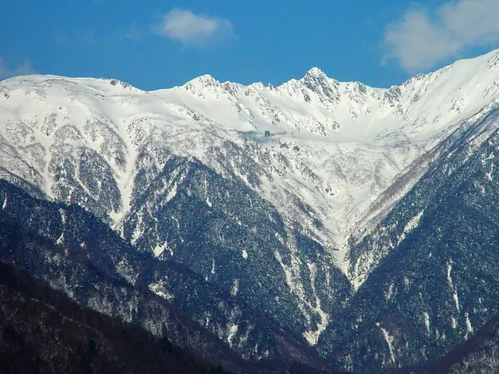
Mount Hoken is a sharp 2,931 m rocky peak in the Kiso Range (Central Alps) of Nagano Prefecture, immediately south of Mount Kiso-Komagatake and straddling Komagane City and Miyata Village. Its pyramidal summit rising above the Senjojiki Cirque is one of the most iconic views in the Central Alps, and the mountain has long been a focus of mountain worship. It lies within Chūō Alps Quasi-National Park (designated 2020) and is listed among the Kōshin'etsu Hyakumeizan and other prominent named-mountain rosters.
Mount Hoken at a glance
- Weather: The most settled day in the next 7 days is Sun, November 8: clear, gusts up to 8 m/s.
- Route: The shortest is Mount Kisokoma and Mount Hoken Loop from Senjojiki: about 3 h, 4.4 km, about 540 m of climbing.
Mount Hoken weather (hourly, 14 days)
Sunrise today 06:12, sunset 16:53
| Tue, 11/3 | Wed, 11/4 | Thu, 11/5 | Fri, 11/6 | Sat, 11/7 | Sun, 11/8 | Mon, 11/9 | Tue, 11/10 | Wed, 11/11 | Thu, 11/12 | Fri, 11/13 | Sat, 11/14 | Sun, 11/15 | Mon, 11/16 | Tue, 11/17 | |||||||||||||||||||||||||||||||||||||||||||||||||||||||||||||||||||||||
|---|---|---|---|---|---|---|---|---|---|---|---|---|---|---|---|---|---|---|---|---|---|---|---|---|---|---|---|---|---|---|---|---|---|---|---|---|---|---|---|---|---|---|---|---|---|---|---|---|---|---|---|---|---|---|---|---|---|---|---|---|---|---|---|---|---|---|---|---|---|---|---|---|---|---|---|---|---|---|---|---|---|---|---|---|---|
| Japan time | 15 | 17 | 19 | 21 | 23 | 1 | 3 | 5 | 7 | 9 | 11 | 13 | 15 | 18 | 21 | 0 | 3 | 6 | 9 | 12 | 15 | 18 | 21 | 0 | 3 | 6 | 9 | 12 | 15 | 18 | 21 | 0 | 3 | 6 | 9 | 12 | 15 | 18 | 21 | 0 | 3 | 6 | 9 | 12 | 15 | 18 | 21 | 0 | 3 | 6 | 9 | 15 | 21 | 3 | 9 | 15 | 21 | 3 | 9 | 15 | 21 | 3 | 9 | 15 | 21 | 3 | 9 | 15 | 21 | 3 | 9 | 15 | 21 | 3 | 9 | 15 | 21 | 3 | 9 | 15 | 21 | 3 | 9 | 15 | |
 |   | | | | |  | |   | | |   |   |   | |   | | |   | |   | |   | | | |   | | |  | | | | | | | | | | | | | | | | | | | | | | | | | | | |   |   | |   |  | | | | | | | | | | | | | | | | | | | | | | | ||
| Temperature | °C | 6° | 1° | -2° | -3° | -3° | -3° | -4° | -4° | -3° | 1° | 5° | 7° | 6° | 2° | 1° | 0° | -1° | 0° | 3° | 4° | 5° | 2° | 1° | 1° | 2° | 1° | 4° | 8° | 6° | -1° | -3° | -3° | -4° | -6° | -2° | -1° | -2° | -8° | -10° | -10° | -10° | -10° | -1° | 4° | 3° | -3° | -3° | -3° | -3° | -3° | 1° | 4° | -4° | -6° | 0° | 0° | -4° | -7° | -6° | -1° | -9° | -10° | -1° | 1° | -7° | -7° | -2° | 1° | -8° | -10° | -2° | 2° | -5° | -4° | 1° | 2° | 0° | 0° | 4° | 4° | -5° | -6° | -1° | 1° |
| Precipitation | mm | 3.6 | 15 | 2.1 | 0.6 | 0.4 | 0.2 | 1.0 | 0.1 | 0.6 | 0.6 | 0.2 | 0.2 | 19 | 14 | 0.8 | 1.3 | ||||||||||||||||||||||||||||||||||||||||||||||||||||||||||||||||||||
| New snow | cm | <.1 | <.1 | ||||||||||||||||||||||||||||||||||||||||||||||||||||||||||||||||||||||||||||||||||
| Snow depth | cm | 0 | 0 | 0 | 0 | 0 | 0 | 0 | 0 | 0 | 0 | 0 | 0 | 0 | 0 | 0 | 0 | 0 | 0 | 0 | 0 | 0 | 0 | 0 | 0 | 0 | 0 | 0 | 0 | 0 | 0 | 0 | 0 | 0 | 0 | 0 | 0 | 0 | 0 | 0 | 0 | 0 | 0 | 0 | 0 | 0 | 0 | 0 | 0 | 0 | 0 | 0 | 0 | 0 | 0 | 0 | 0 | 0 | 0 | 0 | 0 | 0 | 0 | 0 | 0 | 0 | 0 | 0 | 0 | 0 | 0 | 0 | 0 | 0 | 0 | 0 | 0 | 0 | 0 | 0 | 0 | 0 | 0 | 0 | 0 |
| Wind | m/s | 0 | 0 | 0 | 0 | 0 | 0 | 1 | 1 | 1 | 1 | 1 | 2 | 2 | 0 | 1 | 1 | 2 | 1 | 1 | 1 | 1 | 1 | 1 | 1 | 1 | 1 | 1 | 1 | 1 | 1 | 1 | 2 | 2 | 2 | 2 | 2 | 2 | 2 | 2 | 1 | 1 | 1 | 1 | 1 | 1 | 0 | 1 | 1 | 1 | 1 | 2 | 0 | 0 | 0 | 2 | 2 | 1 | 1 | 3 | 2 | 1 | 0 | 2 | 1 | 1 | 1 | 2 | 2 | 1 | 1 | 1 | 1 | 1 | 1 | 2 | 2 | 1 | 1 | 1 | 2 | 1 | 1 | 0 | 2 |
| Wind gusts | m/s | 6 | 5 | 4 | 5 | 5 | 5 | 5 | 5 | 5 | 6 | 7 | 10 | 10 | 8 | 7 | 9 | 13 | 11 | 8 | 6 | 10 | 9 | 7 | 8 | 10 | 10 | 7 | 8 | 9 | 8 | 8 | 9 | 9 | 10 | 11 | 11 | 11 | 11 | 9 | 9 | 9 | 8 | 8 | 8 | 7 | 5 | 8 | 9 | 9 | 9 | 9 | 9 | 5 | 6 | 10 | 15 | 11 | 12 | 16 | 16 | 10 | 8 | 10 | 12 | 7 | 5 | 11 | 10 | 9 | 7 | 5 | 8 | 6 | 8 | 12 | 14 | 15 | 15 | 10 | 12 | 11 | 8 | 6 | 11 |
| Wind dir. | ↓ | ↓ | ↓ | ↓ | ↓ | ↓ | ↓ | ↓ | ↓ | ↓ | ↓ | ↓ | ↓ | ↓ | ↓ | ↓ | ↓ | ↓ | ↓ | ↓ | ↓ | ↓ | ↓ | ↓ | ↓ | ↓ | ↓ | ↓ | ↓ | ↓ | ↓ | ↓ | ↓ | ↓ | ↓ | ↓ | ↓ | ↓ | ↓ | ↓ | ↓ | ↓ | ↓ | ↓ | ↓ | ↓ | ↓ | ↓ | ↓ | ↓ | ↓ | ↓ | ↓ | ↓ | ↓ | ↓ | ↓ | ↓ | ↓ | ↓ | ↓ | ↓ | ↓ | ↓ | ↓ | ↓ | ↓ | ↓ | ↓ | ↓ | ↓ | ↓ | ↓ | ↓ | ↓ | ↓ | ↓ | ↓ | ↓ | ↓ | ↓ | ↓ | ↓ | ↓ | |
Mount Hoken hiking routes
Hiking times are estimates calculated from the terrain.
Huts, campsites and lodging near Mount Hoken
Mountain huts
- Houken-Sansou 2026: open April 5–November 5 · reservation required · sleeps 100
- Teng-Sou 2026: open July 5–October 5 · reservation required · sleeps 100
- Choujou-Sansou 2026: open July 10–October 5 · reservation required · sleeps 50
- 頂上木曽小屋 2022: open July 1–October 15 · reservation required · sleeps 100
- 玉乃窪山荘 2026: open July 11–October 4 · reservation required · sleeps 30
Campsites
- Sainokawara Camp Site
- 檜尾小屋テント場
Lodging
- Hotel Senjojiki
Lists that include Mount Hoken
Koshinetsu 100 Famous Mountains · Shinshu Mountain Cards · Elevations of 1003 Mountains of Japan · 1000 Mountains of Japan
Mount Hoken facts
- Elevation
- 2,931 m
- Location
- Agematsu, Nagano
35.781387, 137.809179 - National Park
- 中央アルプス国定公園
- Website
- www.kankou-komagane.com
- Trail Map
- www.pref.nagano.lg.jp (PDF)
- Access Information
- www.chuo-alps.com
- Wikipedia
- ja.wikipedia.org