
Mount Kaikoma
駒ヶ岳
Ina, Nagano · Elevation 2,967 m
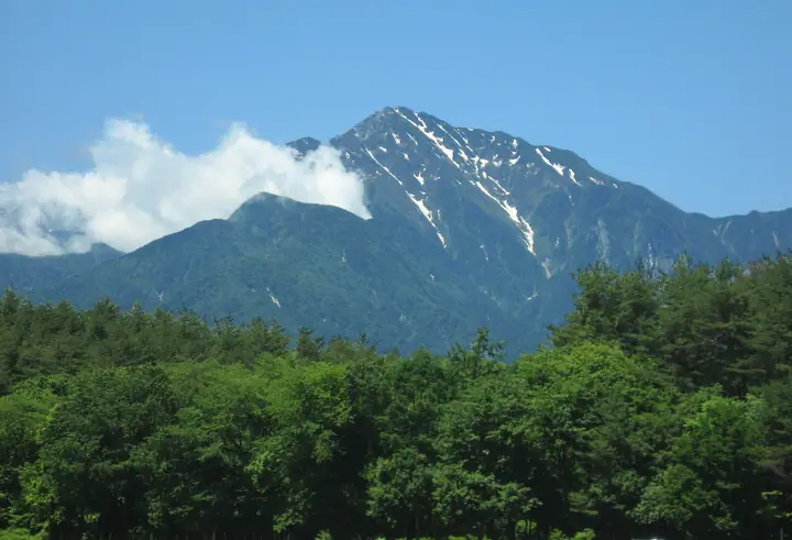
Mount Kaikoma is a 2,967 m mountain in Ina, Nagano, near the border with Hokuto, Yamanashi. It is a principal northern summit of the Akaishi Mountains in Minami Alps National Park. Its steep, almost solitary profile has white granite near the summit. The Kuroto Ridge route begins at Chiku Komagatake Shrine.
Mount Kaikoma at a glance
- Weather: The most settled day in the next 7 days is Sun, November 8: clear, gusts up to 9 m/s. Sat, Nov 7, Mon, Nov 9: strong wind (gusts up to 17 m/s).
- Route: The shortest is Mount Kaikoma Loop from Kitazawa Pass, Up by Sensui Pass and Down by Mount Futago: about 6 h 55 min, 10.4 km, about 1,230 m of climbing.
Mount Kaikoma weather (hourly, 14 days)
Sunrise today 06:10, sunset 16:51
| Tue, 11/3 | Wed, 11/4 | Thu, 11/5 | Fri, 11/6 | Sat, 11/7 | Sun, 11/8 | Mon, 11/9 | Tue, 11/10 | Wed, 11/11 | Thu, 11/12 | Fri, 11/13 | Sat, 11/14 | Sun, 11/15 | Mon, 11/16 | Tue, 11/17 | |||||||||||||||||||||||||||||||||||||||||||||||||||||||||||||||||||||||
|---|---|---|---|---|---|---|---|---|---|---|---|---|---|---|---|---|---|---|---|---|---|---|---|---|---|---|---|---|---|---|---|---|---|---|---|---|---|---|---|---|---|---|---|---|---|---|---|---|---|---|---|---|---|---|---|---|---|---|---|---|---|---|---|---|---|---|---|---|---|---|---|---|---|---|---|---|---|---|---|---|---|---|---|---|---|
| Japan time | 21 | 23 | 1 | 3 | 5 | 7 | 9 | 11 | 13 | 15 | 17 | 19 | 21 | 0 | 3 | 6 | 9 | 12 | 15 | 18 | 21 | 0 | 3 | 6 | 9 | 12 | 15 | 18 | 21 | 0 | 3 | 6 | 9 | 12 | 15 | 18 | 21 | 0 | 3 | 6 | 9 | 12 | 15 | 18 | 21 | 0 | 3 | 6 | 9 | 12 | 15 | 21 | 3 | 9 | 15 | 21 | 3 | 9 | 15 | 21 | 3 | 9 | 15 | 21 | 3 | 9 | 15 | 21 | 3 | 9 | 15 | 21 | 3 | 9 | 15 | 21 | 3 | 9 | 15 | 21 | 3 | 9 | 15 | 21 | |
  |  |   | | |   | | |   | |   | | | | |   |   |   | | | | | | |  | | |  | | | |   | | | | | | | | | | | | | | | | |   |   | | |   | | | | |   | | |  | | | | | | | | | | | | | | | | | | | | | | | | ||
| Temperature | °C | -7° | -8° | -8° | -8° | -8° | -6° | 1° | 3° | 3° | 0° | -2° | -2° | -2° | -2° | -1° | 0° | 4° | 8° | 5° | 2° | 1° | -1° | 0° | 1° | 3° | 6° | 4° | -3° | -5° | -7° | -8° | -9° | -3° | 0° | -2° | -9° | -10° | -10° | -10° | -9° | -1° | 1° | 0° | -6° | -6° | -5° | -4° | -3° | -2° | 3° | 2° | -7° | -9° | -3° | -2° | -6° | -9° | -7° | -5° | -10° | -8° | -2° | -1° | -8° | -7° | -3° | -1° | -8° | -8° | -1° | 1° | -8° | -8° | 1° | 1° | -1° | -1° | 4° | 3° | -6° | -7° | -2° | -1° | -8° |
| Precipitation | mm | 0.4 | 0.3 | 1.6 | 8 | 9 | 4.4 | 0.3 | 1.0 | 0.4 | 0.3 | 0.4 | 0.6 | 0.1 | 0.2 | 0.1 | 8 | 14 | 0.1 | 0.1 | |||||||||||||||||||||||||||||||||||||||||||||||||||||||||||||||||
| New snow | cm | 0.1 | |||||||||||||||||||||||||||||||||||||||||||||||||||||||||||||||||||||||||||||||||||
| Snow depth | cm | 0 | 0 | 0 | 0 | 0 | 0 | 0 | 0 | 0 | 0 | 0 | 0 | 0 | 0 | 0 | 0 | 0 | 0 | 0 | 0 | 0 | 0 | 0 | 0 | 0 | 0 | 0 | 0 | 0 | 0 | 0 | 0 | 0 | 0 | 0 | 0 | 0 | 0 | 0 | 0 | 0 | 0 | 0 | 0 | 0 | 0 | 0 | 0 | 0 | 0 | 0 | 0 | 0 | 0 | 0 | 0 | 0 | 0 | 0 | 0 | 0 | 0 | 0 | 0 | 0 | 0 | 0 | 0 | 0 | 0 | 0 | 0 | 0 | 0 | 0 | 0 | 0 | 0 | 0 | 0 | 0 | 0 | 0 | 0 |
| Wind | m/s | 1 | 1 | 1 | 1 | 1 | 1 | 1 | 1 | 0 | 1 | 1 | 2 | 3 | 3 | 1 | 1 | 1 | 2 | 1 | 1 | 2 | 3 | 3 | 2 | 3 | 3 | 3 | 3 | 3 | 2 | 3 | 3 | 3 | 4 | 3 | 2 | 2 | 2 | 2 | 1 | 0 | 1 | 1 | 1 | 2 | 2 | 2 | 2 | 2 | 3 | 2 | 2 | 2 | 1 | 3 | 3 | 4 | 4 | 2 | 1 | 1 | 2 | 2 | 1 | 2 | 2 | 1 | 1 | 1 | 1 | 1 | 2 | 2 | 2 | 1 | 2 | 2 | 2 | 4 | 1 | 1 | 0 | 1 | 2 |
| Wind gusts | m/s | 9 | 9 | 9 | 9 | 9 | 7 | 7 | 7 | 6 | 7 | 8 | 10 | 11 | 16 | 13 | 14 | 9 | 11 | 11 | 10 | 12 | 16 | 18 | 17 | 13 | 14 | 15 | 15 | 15 | 14 | 15 | 15 | 16 | 17 | 17 | 15 | 13 | 11 | 10 | 10 | 8 | 9 | 9 | 9 | 12 | 14 | 13 | 13 | 14 | 15 | 15 | 8 | 10 | 11 | 14 | 14 | 19 | 20 | 18 | 12 | 8 | 10 | 13 | 11 | 9 | 11 | 11 | 8 | 7 | 7 | 8 | 9 | 11 | 11 | 14 | 16 | 19 | 15 | 15 | 14 | 8 | 6 | 8 | 10 |
| Wind dir. | ↓ | ↓ | ↓ | ↓ | ↓ | ↓ | ↓ | ↓ | ↓ | ↓ | ↓ | ↓ | ↓ | ↓ | ↓ | ↓ | ↓ | ↓ | ↓ | ↓ | ↓ | ↓ | ↓ | ↓ | ↓ | ↓ | ↓ | ↓ | ↓ | ↓ | ↓ | ↓ | ↓ | ↓ | ↓ | ↓ | ↓ | ↓ | ↓ | ↓ | ↓ | ↓ | ↓ | ↓ | ↓ | ↓ | ↓ | ↓ | ↓ | ↓ | ↓ | ↓ | ↓ | ↓ | ↓ | ↓ | ↓ | ↓ | ↓ | ↓ | ↓ | ↓ | ↓ | ↓ | ↓ | ↓ | ↓ | ↓ | ↓ | ↓ | ↓ | ↓ | ↓ | ↓ | ↓ | ↓ | ↓ | ↓ | ↓ | ↓ | ↓ | ↓ | ↓ | ↓ | |
Mount Kaikoma hiking routes
- Mount Kaikoma Loop from Kitazawa Pass, Up by Sensui Pass and Down by Mount Futago 10.4 km · Ascent 1,234 m 北沢峠 (Bus stop)
- Mount Kaikoma via Kuroto Ridge 19.2 km · Ascent 2,471 m 尾白川渓谷駐車場, Ojiragawa Canyon Parking Lot
Hiking times are estimates calculated from the terrain.
Huts, campsites and lodging near Mount Kaikoma
Mountain huts
- Shichijo Cabin Annex 2026: open all year · reservation required · sleeps 24
- 六合目小屋 unstaffed
- Shichijo Cabin 2026: open all year · reservation required · sleeps 24
- 仙水小屋 2026: open June 15–October 25 · reservation required · sleeps 20
- 北沢峠こもれび山荘 2026: open April 25–November 3 · reservation required · sleeps 67
Campsites
- 長衛小屋テント場
Lists that include Mount Kaikoma
100 Famous Japanese Mountains · Japan 200 Famous Mountains · Japan's 300 Famous Mountains · New 100 Famous Flower Mountains · Japan's 100 Highest Mountains · 100 Famous Mountains with First-order Triangulation Points · New Japan 100 Famous Mountains · Illustrated Collection of Japan's Famous Mountains · Koshinetsu 100 Famous Mountains · Yamanashi 100 Famous Mountains · Shinshu 100 Famous Mountains · Shinshu Mountain Cards · Mountains of Hokuto · Elevations of 1003 Mountains of Japan · 1000 Mountains of Japan
Mount Kaikoma facts
- Also known as
- 甲斐駒ヶ岳 · Kaikomagatake
- Elevation
- 2,967 m
- Location
- Ina, Nagano
35.757945, 138.236815 - Website
- www.city.hokuto.lg.jp
- Wikipedia
- ja.wikipedia.org