
Mount Iwate
岩手山
Hachimantai, Iwate / Takizawa, Iwate · Elevation 2,038 m
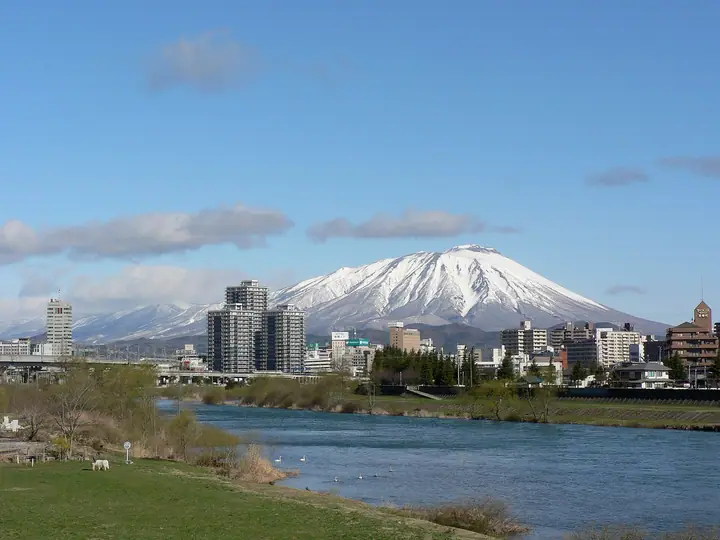
Mount Iwate is the highest peak of Iwate Prefecture, a 2,038.2 m stratovolcano shared by the cities of Takizawa and Hachimantai and the town of Shizukuishi. With a graceful cone on the east and the rugged Onigajo outer rim on the southwest, it is known as "Nanbu Katafuji" (the lopsided Nanbu Fuji) and has long been an object of mountain worship. It holds an annual mountain-opening ceremony on July 1 hosted jointly by the three local municipalities. Routes include the Yanagisawa, Yakehashiri, and Matsukawa trails; the eighth-station emergency hut is staffed in summer. As a continuously monitored active volcano, access is governed by the JMA volcanic alert level.
Mount Iwate at a glance
- Weather: The most settled day in the next 7 days is Wed, November 4: clear, gusts up to 9 m/s. Sat, Nov 7, Sun, Nov 8: strong wind (gusts up to 20 m/s).
- Route: The shortest is Mount Iwate Yanagisawa Course Out-and-Back from Umagaeshi: about 8 h 5 min, 11.7 km, about 1,460 m of climbing.
Mount Iwate weather (hourly, 14 days)
Sunrise today 06:06, sunset 16:33
| Tue, 11/3 | Wed, 11/4 | Thu, 11/5 | Fri, 11/6 | Sat, 11/7 | Sun, 11/8 | Mon, 11/9 | Tue, 11/10 | Wed, 11/11 | Thu, 11/12 | Fri, 11/13 | Sat, 11/14 | Sun, 11/15 | Mon, 11/16 | Tue, 11/17 | |||||||||||||||||||||||||||||||||||||||||||||||||||||||||||||||||||||||
|---|---|---|---|---|---|---|---|---|---|---|---|---|---|---|---|---|---|---|---|---|---|---|---|---|---|---|---|---|---|---|---|---|---|---|---|---|---|---|---|---|---|---|---|---|---|---|---|---|---|---|---|---|---|---|---|---|---|---|---|---|---|---|---|---|---|---|---|---|---|---|---|---|---|---|---|---|---|---|---|---|---|---|---|---|---|
| Japan time | 15 | 17 | 19 | 21 | 23 | 1 | 3 | 5 | 7 | 9 | 11 | 13 | 15 | 18 | 21 | 0 | 3 | 6 | 9 | 12 | 15 | 18 | 21 | 0 | 3 | 6 | 9 | 12 | 15 | 18 | 21 | 0 | 3 | 6 | 9 | 12 | 15 | 18 | 21 | 0 | 3 | 6 | 9 | 12 | 15 | 18 | 21 | 0 | 3 | 6 | 9 | 15 | 21 | 3 | 9 | 15 | 21 | 3 | 9 | 15 | 21 | 3 | 9 | 15 | 21 | 3 | 9 | 15 | 21 | 3 | 9 | 15 | 21 | 3 | 9 | 15 | 21 | 3 | 9 | 15 | 21 | 3 | 9 | 15 | |
  |   | | |  | | | |   |  | | | | | | |   |   |   | | | | | | | | | | |   | |   | | |   | | |   |   |   | | | |   | |   | | | | | |   | | | | | | | | | | | | | | |   | | | | | |  | | | | | | | | | | | | ||
| Temperature | °C | -1° | -4° | -5° | -6° | -8° | -8° | -8° | -6° | -5° | 0° | 3° | 4° | 3° | -4° | -4° | -4° | -4° | -2° | -1° | 1° | 1° | 0° | 1° | 0° | 0° | 0° | 3° | 4° | 3° | 0° | -4° | -6° | -6° | -7° | -6° | -6° | -7° | -8° | -8° | -8° | -8° | -8° | -6° | -5° | -5° | -7° | -8° | -9° | -9° | -11° | -5° | -4° | -8° | -10° | -6° | -3° | -7° | -6° | -7° | -7° | -9° | -11° | -5° | -3° | -6° | -6° | -6° | -5° | -11° | -13° | -6° | -2° | -10° | -10° | -3° | 0° | -4° | -4° | 0° | -4° | -9° | -12° | -7° | -3° |
| Precipitation | mm | 0.6 | 4.9 | 5 | 1.5 | 1.8 | 2.1 | 4.2 | 1.4 | 0.2 | 0.4 | 1.6 | 0.9 | 0.2 | 0.3 | 0.5 | 0.6 | 0.7 | 0.6 | 0.9 | 1.1 | 0.5 | 0.1 | 0.2 | 0.2 | 0.2 | 0.3 | 9 | 7 | 2.1 | 3.0 | 0.2 | 0.6 | 2.4 | 1.6 | 1.7 | 1.5 | ||||||||||||||||||||||||||||||||||||||||||||||||
| New snow | cm | <.1 | <.1 | 0.2 | 0.5 | 0.4 | 0.6 | 0.6 | 0.3 | 0.1 | 0.2 | 0.2 | 0.2 | <.1 | <.1 | <.1 | <.1 | <.1 | 0.2 | 2.3 | 0.9 | 0.6 | <.1 | <.1 | <.1 | 0.3 | <.1 | <.1 | 0.3 | ||||||||||||||||||||||||||||||||||||||||||||||||||||||||
| Snow depth | cm | 0 | 0 | 0 | 0 | 0 | 0 | 0 | 0 | 0 | 0 | 0 | 0 | 0 | 0 | 0 | 0 | 0 | 0 | 0 | 0 | 0 | 0 | 0 | 0 | 0 | 0 | 0 | 0 | 0 | 0 | 0 | 0 | <1 | <1 | <1 | <1 | <1 | <1 | <1 | 1 | 1 | 1 | 1 | <1 | <1 | <1 | <1 | <1 | <1 | <1 | <1 | <1 | <1 | <1 | <1 | <1 | <1 | 2 | 2 | 2 | 2 | 2 | 2 | 2 | 2 | 2 | 2 | 2 | 2 | 2 | 2 | 1 | 1 | 1 | 1 | 1 | <1 | <1 | <1 | <1 | <1 | <1 | <1 | <1 |
| Wind | m/s | 3 | 1 | 1 | 1 | 1 | 1 | 1 | 1 | 1 | 1 | 1 | 1 | 1 | 1 | 1 | 1 | 1 | 2 | 2 | 0 | 1 | 1 | 1 | 1 | 0 | 1 | 2 | 2 | 3 | 2 | 3 | 3 | 3 | 1 | 3 | 4 | 3 | 3 | 3 | 3 | 2 | 2 | 3 | 5 | 3 | 2 | 1 | 1 | 0 | 2 | 1 | 1 | 1 | 1 | 1 | 3 | 1 | 2 | 5 | 4 | 1 | 1 | 1 | 3 | 1 | 1 | 2 | 3 | 0 | 1 | 1 | 1 | 1 | 0 | 1 | 2 | 1 | 1 | 0 | 2 | 1 | 0 | 0 | 1 |
| Wind gusts | m/s | 13 | 12 | 8 | 7 | 7 | 8 | 9 | 9 | 9 | 9 | 8 | 7 | 7 | 5 | 4 | 7 | 8 | 9 | 9 | 8 | 4 | 3 | 5 | 6 | 6 | 6 | 7 | 14 | 15 | 14 | 14 | 17 | 14 | 13 | 15 | 20 | 18 | 17 | 15 | 15 | 14 | 13 | 15 | 19 | 19 | 13 | 11 | 8 | 6 | 7 | 8 | 8 | 6 | 5 | 6 | 9 | 11 | 9 | 16 | 19 | 13 | 6 | 7 | 9 | 8 | 6 | 7 | 11 | 10 | 5 | 6 | 5 | 6 | 4 | 5 | 8 | 7 | 7 | 5 | 11 | 11 | 8 | 5 | 5 |
| Wind dir. | ↓ | ↓ | ↓ | ↓ | ↓ | ↓ | ↓ | ↓ | ↓ | ↓ | ↓ | ↓ | ↓ | ↓ | ↓ | ↓ | ↓ | ↓ | ↓ | ↓ | ↓ | ↓ | ↓ | ↓ | ↓ | ↓ | ↓ | ↓ | ↓ | ↓ | ↓ | ↓ | ↓ | ↓ | ↓ | ↓ | ↓ | ↓ | ↓ | ↓ | ↓ | ↓ | ↓ | ↓ | ↓ | ↓ | ↓ | ↓ | ↓ | ↓ | ↓ | ↓ | ↓ | ↓ | ↓ | ↓ | ↓ | ↓ | ↓ | ↓ | ↓ | ↓ | ↓ | ↓ | ↓ | ↓ | ↓ | ↓ | ↓ | ↓ | ↓ | ↓ | ↓ | ↓ | ↓ | ↓ | ↓ | ↓ | ↓ | ↓ | ↓ | ↓ | ↓ | ↓ | |
Mount Iwate live cameras
Mount Iwate hiking routes
- Mount Iwate Yanagisawa Course Out-and-Back from Umagaeshi 11.7 km · Ascent 1,461 m 第一駐車場
- Mount Iwate via the Yakehashiri Course 13.4 km · Ascent 1,470 m 焼走り登山口, 焼走り駐車場, 焼走りの湯 (parking)
- Mount Iwate Nanataki Route Return from Kenmin-no-Mori 19.7 km · Ascent 1,439 m
Hiking times are estimates calculated from the terrain.
Huts, campsites and lodging near Mount Iwate
Mountain huts
- 平笠不動避難小屋 unstaffed · sleeps 15
- 不動平避難小屋 unstaffed · sleeps 15
- 岩手山八合目避難小屋 2026: open July 1–October 16 · reservation required · sleeps 100
Campsites
- 馬返しキャンプ場
- 焼走り野営場
Lists that include Mount Iwate
100 Famous Japanese Mountains · Japan 200 Famous Mountains · Japan's 300 Famous Mountains · 100 Famous Mountains with First-order Triangulation Points · New Japan 100 Famous Mountains · Highest Peaks by Prefecture · Illustrated Collection of Japan's Famous Mountains · 100 Famous Hot Spring Mountains · 100 Fujis of Japan · Tohoku 100 Famous Mountains · Iwate 100 Famous Mountains · Elevations of 1003 Mountains of Japan · 1000 Mountains of Japan
Mount Iwate facts
- Also known as
- 南部富士 · 南部片富士 · 巌鷲山
- Elevation
- 2,038 m
- Location
- Hachimantai, Iwate / Takizawa, Iwate
39.852582, 141.001142 - Volcano
- Active volcano (岩手山)
- Season Opens
- July 1
- Website
- www.city.takizawa.iwate.jp
- Trail Map
- www.env.go.jp
- Wikipedia
- ja.wikipedia.org