
Mount Ōbuka
大深岳
Hachimantai, Iwate / Semboku, Akita · Elevation 1,541 m
Mount Ōbuka (1,541 m) is a shield volcano on the border of Hachimantai City (Iwate) and Senboku City (Akita), in the South Hachimantai sector of Towada-Hachimantai National Park. It stands at the meeting point of the Ura-Iwate traverse — the long ridge route from Hachimantai to Mount Iwate — and the prefectural-border ridge that rims the headwaters of the Tamagawa River. A small unstaffed shelter, Ōbuka-sansō, sits just below the summit, and the area is prized for quiet ridge walking away from the crowds on the main Hachimantai plateau.
Mount Ōbuka at a glance
- Weather: The most settled day in the next 7 days is Wed, November 4: clear, gusts up to 15 m/s. Fri, Nov 6, Sat, Nov 7, Sun, Nov 8: strong wind (gusts up to 26 m/s).
- Route: The shortest is Mitsuishiyama Loop via Gentagadake from Matsukawa Onsen: about 8 h 23 min, 14.7 km, about 1,000 m of climbing.
Mount Ōbuka weather (hourly, 14 days)
Sunrise today 06:07, sunset 16:34
| Tue, 11/3 | Wed, 11/4 | Thu, 11/5 | Fri, 11/6 | Sat, 11/7 | Sun, 11/8 | Mon, 11/9 | Tue, 11/10 | Wed, 11/11 | Thu, 11/12 | Fri, 11/13 | Sat, 11/14 | Sun, 11/15 | Mon, 11/16 | Tue, 11/17 | |||||||||||||||||||||||||||||||||||||||||||||||||||||||||||||||||||||||
|---|---|---|---|---|---|---|---|---|---|---|---|---|---|---|---|---|---|---|---|---|---|---|---|---|---|---|---|---|---|---|---|---|---|---|---|---|---|---|---|---|---|---|---|---|---|---|---|---|---|---|---|---|---|---|---|---|---|---|---|---|---|---|---|---|---|---|---|---|---|---|---|---|---|---|---|---|---|---|---|---|---|---|---|---|---|
| Japan time | 15 | 17 | 19 | 21 | 23 | 1 | 3 | 5 | 7 | 9 | 11 | 13 | 15 | 18 | 21 | 0 | 3 | 6 | 9 | 12 | 15 | 18 | 21 | 0 | 3 | 6 | 9 | 12 | 15 | 18 | 21 | 0 | 3 | 6 | 9 | 12 | 15 | 18 | 21 | 0 | 3 | 6 | 9 | 12 | 15 | 18 | 21 | 0 | 3 | 6 | 9 | 15 | 21 | 3 | 9 | 15 | 21 | 3 | 9 | 15 | 21 | 3 | 9 | 15 | 21 | 3 | 9 | 15 | 21 | 3 | 9 | 15 | 21 | 3 | 9 | 15 | 21 | 3 | 9 | 15 | 21 | 3 | 9 | 15 | |
  |   |   | |  |   | | | |  | | |   | | | | |   |   | | | | | | | | | | | |   | |   | |   | |   | | | | | | | |   | | |   | | | | | | | | | | | | | | | | | | | | | | | | |  | | | | | | |   | | | | | ||
| Temperature | °C | 0° | -2° | -3° | -3° | -4° | -3° | -2° | -1° | 0° | 3° | 4° | 5° | 4° | -1° | 0° | 0° | 0° | 2° | 4° | 5° | 6° | 5° | 5° | 5° | 5° | 5° | 6° | 7° | 5° | 1° | -2° | -4° | -5° | -6° | -6° | -5° | -5° | -6° | -7° | -7° | -6° | -6° | -5° | -4° | -5° | -6° | -6° | -6° | -6° | -8° | -4° | -4° | -7° | -9° | -4° | -1° | -4° | -3° | -3° | -4° | -7° | -7° | -3° | -2° | -3° | -3° | -4° | -4° | -8° | -10° | -3° | -1° | -7° | -7° | 2° | 2° | 1° | 0° | 2° | -2° | -7° | -9° | -4° | -3° |
| Precipitation | mm | 0.4 | 4.3 | 4.7 | 1.7 | 1.8 | 1.2 | 4.0 | 1.9 | 0.7 | 1.0 | 3.3 | 2.7 | 0.7 | 1.7 | 1.2 | 1.4 | 1.6 | 1.2 | 1.4 | 2.0 | 0.8 | 0.3 | 0.3 | 0.3 | 0.3 | 0.1 | 0.4 | 0.1 | 1.4 | 10 | 7 | 2.8 | 0.2 | 0.3 | 4.0 | 1.4 | 3.4 | 2.0 | 2.6 | 2.7 | ||||||||||||||||||||||||||||||||||||||||||||
| New snow | cm | <.1 | 0.5 | 0.8 | 1.3 | 1.6 | 1.2 | 1.5 | 2.0 | 0.8 | 0.3 | 0.3 | 0.3 | 0.3 | <.1 | <.1 | 0.1 | <.1 | 0.3 | 0.1 | 1.4 | 8.7 | 6.1 | 2.8 | <.1 | <.1 | 0.2 | 0.2 | 3.6 | <.1 | <.1 | <.1 | 1.0 | 2.6 | <.1 | ||||||||||||||||||||||||||||||||||||||||||||||||||
| Snow depth | cm | <1 | <1 | <1 | <1 | <1 | <1 | <1 | <1 | <1 | <1 | 0 | 0 | 0 | 0 | 0 | 0 | 0 | 0 | 0 | 0 | 0 | 0 | 0 | 0 | 0 | 0 | 0 | 0 | 0 | 0 | <1 | <1 | 2 | 3 | 3 | 4 | 5 | 6 | 6 | 6 | 6 | 6 | 6 | 6 | 6 | 6 | 6 | 5 | 5 | 5 | 5 | 5 | 5 | 5 | 5 | 5 | 6 | 12 | 15 | 16 | 16 | 16 | 16 | 14 | 14 | 17 | 17 | 17 | 16 | 16 | 16 | 15 | 15 | 15 | 15 | 13 | 12 | 11 | 10 | 9 | 10 | 10 | 10 | 10 |
| Wind | m/s | 6 | 4 | 4 | 4 | 3 | 3 | 4 | 4 | 5 | 5 | 4 | 4 | 2 | 0 | 1 | 2 | 2 | 2 | 2 | 1 | 1 | 1 | 1 | 2 | 2 | 2 | 2 | 6 | 6 | 6 | 7 | 7 | 6 | 6 | 6 | 7 | 6 | 8 | 7 | 7 | 7 | 7 | 8 | 9 | 7 | 6 | 5 | 4 | 4 | 1 | 3 | 3 | 1 | 1 | 1 | 3 | 5 | 1 | 4 | 3 | 2 | 2 | 4 | 3 | 2 | 1 | 3 | 5 | 2 | 2 | 2 | 2 | 1 | 0 | 1 | 1 | 2 | 1 | 1 | 3 | 5 | 3 | 3 | 2 |
| Wind gusts | m/s | 17 | 17 | 12 | 12 | 11 | 11 | 12 | 13 | 14 | 15 | 14 | 12 | 11 | 6 | 5 | 6 | 7 | 8 | 8 | 7 | 5 | 4 | 6 | 6 | 7 | 7 | 10 | 20 | 20 | 19 | 20 | 21 | 19 | 18 | 19 | 24 | 25 | 23 | 21 | 21 | 21 | 21 | 22 | 26 | 25 | 21 | 17 | 14 | 11 | 11 | 11 | 11 | 9 | 6 | 6 | 8 | 15 | 14 | 12 | 17 | 10 | 7 | 11 | 12 | 10 | 7 | 11 | 14 | 13 | 8 | 7 | 9 | 6 | 4 | 4 | 6 | 7 | 7 | 5 | 10 | 16 | 14 | 9 | 9 |
| Wind dir. | ↓ | ↓ | ↓ | ↓ | ↓ | ↓ | ↓ | ↓ | ↓ | ↓ | ↓ | ↓ | ↓ | ↓ | ↓ | ↓ | ↓ | ↓ | ↓ | ↓ | ↓ | ↓ | ↓ | ↓ | ↓ | ↓ | ↓ | ↓ | ↓ | ↓ | ↓ | ↓ | ↓ | ↓ | ↓ | ↓ | ↓ | ↓ | ↓ | ↓ | ↓ | ↓ | ↓ | ↓ | ↓ | ↓ | ↓ | ↓ | ↓ | ↓ | ↓ | ↓ | ↓ | ↓ | ↓ | ↓ | ↓ | ↓ | ↓ | ↓ | ↓ | ↓ | ↓ | ↓ | ↓ | ↓ | ↓ | ↓ | ↓ | ↓ | ↓ | ↓ | ↓ | ↓ | ↓ | ↓ | ↓ | ↓ | ↓ | ↓ | ↓ | ↓ | ↓ | ↓ | |
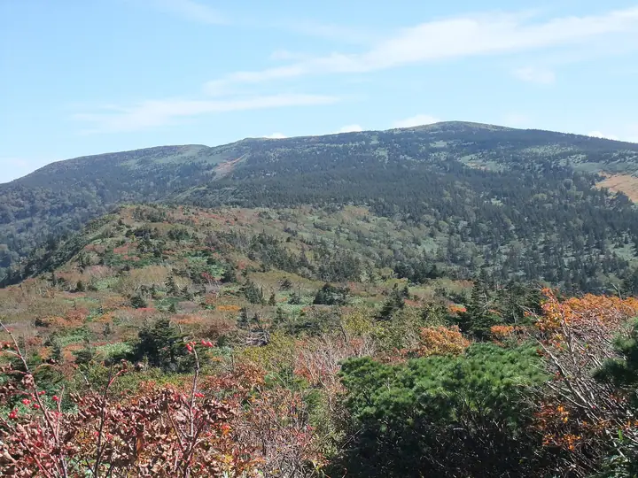
Mount Ōbuka hiking routes
Hiking times are estimates calculated from the terrain.
Huts, campsites and lodging near Mount Ōbuka
Mountain huts
Campsites
- 県営松川キャンプ場
Lodging
- 松川温泉 峡雲荘
- 松川温泉 松川荘
Lists that include Mount Ōbuka
Elevations of 1003 Mountains of Japan · 1000 Mountains of Japan
Mount Ōbuka facts
- Elevation
- 1,541 m
- Location
- Hachimantai, Iwate / Semboku, Akita
39.881108, 140.879724 - National Park
- 十和田八幡平国立公園
- Website
- www.env.go.jp
- Wikipedia
- ja.wikipedia.org