
Ogato
王ヶ頭
Matsumoto, Nagano · Elevation 2,034 m
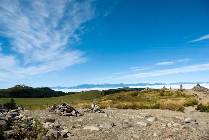
Ogato, at 2,034 m, is the highest peak of the Utsukushigahara plateau and is surrounded by transmission towers. Its level uplands offer views of Mount Fuji, the Northern, Central and Southern Alps, Norikuradake, Ontakesan and Asamayama. Private cars cannot reach the summit; visitors walk from road ends such as the Utsukushigahara Nature Conservation Center.
Ogato at a glance
- Weather: The most settled day in the next 7 days is Wed, November 4: clear, gusts up to 8 m/s. Fri, Nov 6: strong wind (gusts up to 15 m/s).
- Route: The shortest is Mount Ogato and Ogahana Circuit from Utsukushigahara Nature Conservation Center: about 1 h 52 min, 4.4 km, about 160 m of climbing.
Ogato weather (hourly, 14 days)
Sunrise today 06:12, sunset 16:51
| Tue, 11/3 | Wed, 11/4 | Thu, 11/5 | Fri, 11/6 | Sat, 11/7 | Sun, 11/8 | Mon, 11/9 | Tue, 11/10 | Wed, 11/11 | Thu, 11/12 | Fri, 11/13 | Sat, 11/14 | Sun, 11/15 | Mon, 11/16 | Tue, 11/17 | |||||||||||||||||||||||||||||||||||||||||||||||||||||||||||||||||||||||
|---|---|---|---|---|---|---|---|---|---|---|---|---|---|---|---|---|---|---|---|---|---|---|---|---|---|---|---|---|---|---|---|---|---|---|---|---|---|---|---|---|---|---|---|---|---|---|---|---|---|---|---|---|---|---|---|---|---|---|---|---|---|---|---|---|---|---|---|---|---|---|---|---|---|---|---|---|---|---|---|---|---|---|---|---|---|
| Japan time | 15 | 17 | 19 | 21 | 23 | 1 | 3 | 5 | 7 | 9 | 11 | 13 | 15 | 18 | 21 | 0 | 3 | 6 | 9 | 12 | 15 | 18 | 21 | 0 | 3 | 6 | 9 | 12 | 15 | 18 | 21 | 0 | 3 | 6 | 9 | 12 | 15 | 18 | 21 | 0 | 3 | 6 | 9 | 12 | 15 | 18 | 21 | 0 | 3 | 6 | 9 | 15 | 21 | 3 | 9 | 15 | 21 | 3 | 9 | 15 | 21 | 3 | 9 | 15 | 21 | 3 | 9 | 15 | 21 | 3 | 9 | 15 | 21 | 3 | 9 | 15 | 21 | 3 | 9 | 15 | 21 | 3 | 9 | 15 | |
  |   |  | | | | | | | |  | |   |   | |   | |   |   |   | |  |   | | | | | | | | | | | | | | | | | | | | | | | | | | | | | | | | | | | |   | | |  | | | | | | | | | | | | | |   | | | | | | | | | ||
| Temperature | °C | 4° | 1° | -2° | -3° | -2° | -2° | -2° | -2° | -1° | 3° | 7° | 9° | 7° | 2° | 2° | 2° | 2° | 2° | 4° | 8° | 9° | 5° | 5° | 4° | 4° | 4° | 9° | 13° | 11° | 4° | 1° | -1° | -2° | -3° | 0° | 3° | 1° | -5° | -6° | -8° | -8° | -8° | -1° | 3° | 1° | -4° | -4° | -4° | -3° | -3° | 3° | 3° | -3° | -4° | 2° | 6° | 0° | -2° | -1° | 0° | -5° | -5° | 1° | 3° | -4° | -3° | 0° | 0° | -5° | -6° | 1° | 7° | -2° | -1° | 6° | 7° | 4° | 4° | 9° | 4° | -2° | -5° | -1° | 3° |
| Precipitation | mm | 1.5 | 10 | 3.9 | 1.7 | 0.7 | 0.2 | 0.1 | 0.2 | 0.2 | 0.2 | 7 | 7 | 2.5 | 0.3 | ||||||||||||||||||||||||||||||||||||||||||||||||||||||||||||||||||||||
| New snow | cm | 0.1 | |||||||||||||||||||||||||||||||||||||||||||||||||||||||||||||||||||||||||||||||||||
| Snow depth | cm | 0 | 0 | 0 | 0 | 0 | 0 | 0 | 0 | 0 | 0 | 0 | 0 | 0 | 0 | 0 | 0 | 0 | 0 | 0 | 0 | 0 | 0 | 0 | 0 | 0 | 0 | 0 | 0 | 0 | 0 | 0 | 0 | 0 | 0 | 0 | 0 | 0 | 0 | 0 | 0 | 0 | 0 | 0 | 0 | 0 | 0 | 0 | 0 | 0 | 0 | 0 | 0 | 0 | 0 | 0 | 0 | 0 | 0 | 0 | 0 | 0 | 0 | 0 | 0 | 0 | 0 | 0 | 0 | 0 | 0 | 0 | 0 | 0 | 0 | 0 | 0 | 0 | 0 | 0 | 0 | 0 | 0 | 0 | 0 |
| Wind | m/s | 2 | 0 | 1 | 0 | 0 | 0 | 0 | 0 | 0 | 1 | 1 | 2 | 3 | 2 | 2 | 2 | 1 | 1 | 1 | 0 | 0 | 1 | 1 | 2 | 2 | 1 | 2 | 5 | 5 | 2 | 2 | 2 | 3 | 2 | 1 | 3 | 1 | 1 | 1 | 1 | 1 | 1 | 2 | 3 | 3 | 1 | 0 | 1 | 0 | 0 | 1 | 2 | 0 | 1 | 1 | 4 | 3 | 5 | 3 | 4 | 0 | 1 | 1 | 3 | 0 | 2 | 2 | 3 | 1 | 1 | 0 | 1 | 1 | 3 | 3 | 3 | 2 | 4 | 2 | 4 | 2 | 1 | 1 | 2 |
| Wind gusts | m/s | 7 | 7 | 4 | 3 | 3 | 3 | 3 | 3 | 2 | 4 | 6 | 6 | 8 | 8 | 6 | 6 | 6 | 8 | 5 | 5 | 6 | 6 | 5 | 7 | 9 | 9 | 9 | 15 | 15 | 15 | 8 | 10 | 11 | 10 | 9 | 11 | 10 | 6 | 5 | 5 | 6 | 6 | 7 | 8 | 10 | 9 | 5 | 6 | 6 | 6 | 7 | 10 | 7 | 4 | 6 | 13 | 13 | 18 | 18 | 15 | 12 | 5 | 6 | 10 | 9 | 7 | 8 | 11 | 10 | 5 | 5 | 6 | 7 | 10 | 11 | 16 | 12 | 15 | 14 | 13 | 13 | 8 | 5 | 7 |
| Wind dir. | ↓ | ↓ | ↓ | ↓ | ↓ | ↓ | ↓ | ↓ | ↓ | ↓ | ↓ | ↓ | ↓ | ↓ | ↓ | ↓ | ↓ | ↓ | ↓ | ↓ | ↓ | ↓ | ↓ | ↓ | ↓ | ↓ | ↓ | ↓ | ↓ | ↓ | ↓ | ↓ | ↓ | ↓ | ↓ | ↓ | ↓ | ↓ | ↓ | ↓ | ↓ | ↓ | ↓ | ↓ | ↓ | ↓ | ↓ | ↓ | ↓ | ↓ | ↓ | ↓ | ↓ | ↓ | ↓ | ↓ | ↓ | ↓ | ↓ | ↓ | ↓ | ↓ | ↓ | ↓ | ↓ | ↓ | ↓ | ↓ | ↓ | ↓ | ↓ | ↓ | ↓ | ↓ | ↓ | ↓ | ↓ | ↓ | ↓ | ↓ | ↓ | ↓ | ↓ | ↓ | |
Ogato hiking routes
- Mount Ogato and Ogahana Circuit from Utsukushigahara Nature Conservation Center 4.4 km · Ascent 160 m parking
- Mount Ogato Return from Michi-no-Eki Utsukushigahara via Mount Ushibuse and Utsukushi-no-to 8.5 km · Ascent 207 m 道の駅美ヶ原高原美術館
- Matsumoto Utsukushigahara Loop up the Hundred Bends by Eboshi Rock to the High Point Ogato, down the Datekawara Trail 10.8 km · Ascent 706 m parking
Hiking times are estimates calculated from the terrain.
Huts, campsites and lodging near Ogato
Campsites
- 桜清水オートキャンプ場
Lodging
- 王ヶ頭ホテル
- 美ヶ原高原ホテル山本小屋
- 山本小屋ふる里館
Ogato facts
- Elevation
- 2,034 m
- Location
- Matsumoto, Nagano
36.225832, 138.107446 - Website
- www.venus-line.net
- Access Information
- www.city.matsumoto.nagano.jp
- Wikipedia
- ja.wikipedia.org