
Mt. Teineyama
手稲山
Sapporo, Hokkaido · Elevation 1,023 m
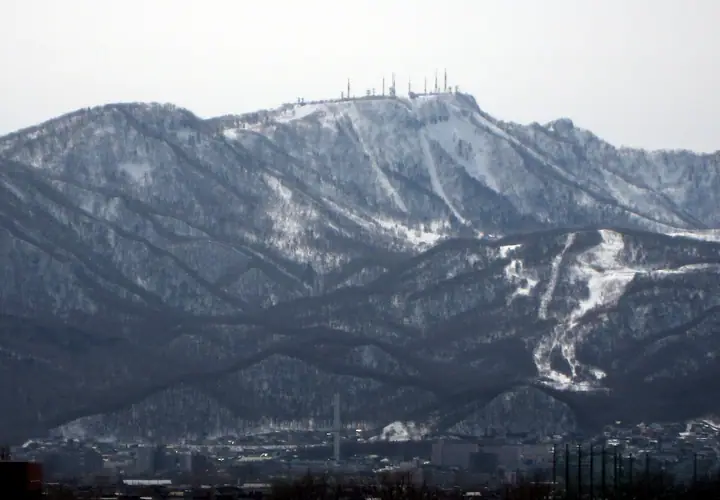
Mt. Teineyama is a 1,023.1-meter peak straddling Sapporo's Teine and Nishi wards in Hokkaido, an emblem of Teine Ward. The name derives from the Ainu word "Teine-i," meaning "wet place." During the 1972 Sapporo Winter Olympics the mountain hosted the alpine skiing (slalom and giant slalom), luge, and bobsleigh events, and the Sapporo Teine ski resort still occupies its slopes today. Summer hikers approach the summit via the Heiwa Falls route from the Nishi side or the North Ridge route from the Teinehoncho and Kanayama trailheads in Teine, gaining sweeping views over the Ishikari Plain and the Sea of Japan.
Mt. Teineyama at a glance
- Weather: The most settled day in the next 7 days is Thu, November 5: clear, gusts up to 9 m/s. Sat, Nov 7, Sun, Nov 8: strong wind (gusts up to 25 m/s).
- Route: The shortest is Mount Teine Ski Area Course Out-and-Back: about 2 h 30 min, 4.2 km, about 450 m of climbing.
Mt. Teineyama weather (hourly, 14 days)
Sunrise today 06:11, sunset 16:26
| Tue, 11/3 | Wed, 11/4 | Thu, 11/5 | Fri, 11/6 | Sat, 11/7 | Sun, 11/8 | Mon, 11/9 | Tue, 11/10 | Wed, 11/11 | Thu, 11/12 | Fri, 11/13 | Sat, 11/14 | Sun, 11/15 | Mon, 11/16 | Tue, 11/17 | |||||||||||||||||||||||||||||||||||||||||||||||||||||||||||||||||||||||
|---|---|---|---|---|---|---|---|---|---|---|---|---|---|---|---|---|---|---|---|---|---|---|---|---|---|---|---|---|---|---|---|---|---|---|---|---|---|---|---|---|---|---|---|---|---|---|---|---|---|---|---|---|---|---|---|---|---|---|---|---|---|---|---|---|---|---|---|---|---|---|---|---|---|---|---|---|---|---|---|---|---|---|---|---|---|
| Japan time | 21 | 23 | 1 | 3 | 5 | 7 | 9 | 11 | 13 | 15 | 17 | 19 | 21 | 0 | 3 | 6 | 9 | 12 | 15 | 18 | 21 | 0 | 3 | 6 | 9 | 12 | 15 | 18 | 21 | 0 | 3 | 6 | 9 | 12 | 15 | 18 | 21 | 0 | 3 | 6 | 9 | 12 | 15 | 18 | 21 | 0 | 3 | 6 | 9 | 12 | 15 | 21 | 3 | 9 | 15 | 21 | 3 | 9 | 15 | 21 | 3 | 9 | 15 | 21 | 3 | 9 | 15 | 21 | 3 | 9 | 15 | 21 | 3 | 9 | 15 | 21 | 3 | 9 | 15 | 21 | 3 | 9 | 15 | 21 | |
  |   | | | |   |   |  | | |  | | | |   | | | | |   |   | | | |   |   | | |   | | | |   | | | | | | | | | | |   | | | | | |   | | | | | | | |   | | | | | | | | | | | | | | | |   | | | |   | | |   | | | | ||
| Temperature | °C | -3° | -4° | -4° | -2° | -2° | -2° | 0° | 1° | 2° | 2° | -4° | -5° | -4° | -3° | -2° | -1° | 6° | 7° | 7° | 2° | 4° | 3° | 4° | 4° | 5° | 10° | 6° | 1° | -1° | -4° | -6° | -6° | -5° | -5° | -5° | -5° | -6° | -5° | -6° | -6° | -5° | -4° | -5° | -6° | -7° | -7° | -7° | -7° | -6° | -5° | -6° | -7° | -10° | -4° | -3° | -6° | -6° | -2° | -2° | -6° | -5° | -2° | -2° | -5° | -6° | -7° | -5° | -5° | -5° | -2° | 0° | -7° | 0° | 3° | 3° | 2° | 1° | -1° | -3° | -5° | -7° | -3° | -2° | -4° |
| Precipitation | mm | 0.4 | 1.2 | 2.9 | 0.7 | 0.1 | 0.8 | 1.7 | 1.3 | 4.6 | 7 | 1.4 | 0.8 | 0.8 | 0.7 | 1.1 | 1.4 | 1.2 | 1.6 | 1.5 | 1.1 | 0.7 | 0.4 | 0.3 | 0.3 | 0.2 | 0.2 | 0.1 | 0.1 | 0.1 | 0.9 | 0.6 | 0.3 | 0.8 | 0.3 | 0.6 | 0.7 | 1.1 | 0.7 | 0.2 | 0.3 | 1.7 | 4.7 | 2.9 | 0.7 | ||||||||||||||||||||||||||||||||||||||||
| New snow | cm | 0.4 | 1.2 | 2.9 | 0.6 | <.1 | <.1 | 0.5 | 1.1 | 1.4 | 1.2 | 1.6 | 1.5 | 1.1 | 0.7 | 0.4 | 0.3 | 0.3 | 0.2 | 0.2 | 0.1 | 0.1 | <.1 | <.1 | <.1 | <.1 | <.1 | 0.1 | <.1 | <.1 | <.1 | <.1 | 0.9 | 0.6 | <.1 | 0.3 | 0.8 | <.1 | 0.3 | 0.6 | 0.7 | 1.1 | 0.7 | 1.1 | 2.6 | 0.7 | <.1 | ||||||||||||||||||||||||||||||||||||||
| Snow depth | cm | <1 | 1 | 3 | 4 | 4 | 4 | 4 | 3 | 3 | 3 | 3 | 3 | 3 | 3 | 3 | 2 | 2 | 1 | 1 | 1 | <1 | <1 | <1 | <1 | 0 | 0 | 0 | 0 | 0 | 1 | 2 | 2 | 3 | 4 | 5 | 5 | 6 | 7 | 8 | 9 | 9 | 9 | 10 | 10 | 10 | 10 | 9 | 9 | 9 | 9 | 9 | 9 | 9 | 9 | 8 | 8 | 9 | 9 | 9 | 9 | 9 | 9 | 9 | 9 | 9 | 10 | 10 | 11 | 11 | 11 | 10 | 10 | 10 | 9 | 6 | 4 | 2 | 3 | 4 | 5 | 5 | 5 | 4 | 4 |
| Wind | m/s | 2 | 2 | 2 | 3 | 4 | 4 | 4 | 2 | 1 | 1 | 1 | 3 | 3 | 3 | 4 | 3 | 2 | 2 | 1 | 2 | 2 | 1 | 1 | 1 | 2 | 3 | 4 | 5 | 5 | 5 | 6 | 6 | 7 | 7 | 8 | 8 | 8 | 7 | 6 | 5 | 5 | 6 | 5 | 4 | 2 | 3 | 3 | 3 | 3 | 3 | 3 | 2 | 3 | 1 | 1 | 0 | 1 | 1 | 2 | 2 | 2 | 1 | 4 | 2 | 2 | 5 | 4 | 3 | 2 | 1 | 1 | 3 | 3 | 2 | 2 | 2 | 2 | 3 | 5 | 5 | 3 | 2 | 2 | 1 |
| Wind gusts | m/s | 11 | 9 | 12 | 13 | 13 | 14 | 14 | 12 | 7 | 6 | 5 | 8 | 10 | 10 | 11 | 11 | 9 | 7 | 6 | 7 | 7 | 6 | 6 | 5 | 5 | 8 | 13 | 19 | 18 | 19 | 19 | 19 | 21 | 24 | 25 | 26 | 24 | 23 | 22 | 19 | 16 | 17 | 17 | 14 | 12 | 10 | 10 | 9 | 10 | 11 | 11 | 11 | 8 | 8 | 6 | 5 | 3 | 4 | 8 | 7 | 7 | 7 | 13 | 12 | 8 | 15 | 16 | 12 | 9 | 7 | 5 | 8 | 9 | 11 | 10 | 11 | 9 | 9 | 14 | 15 | 13 | 9 | 7 | 6 |
| Wind dir. | ↓ | ↓ | ↓ | ↓ | ↓ | ↓ | ↓ | ↓ | ↓ | ↓ | ↓ | ↓ | ↓ | ↓ | ↓ | ↓ | ↓ | ↓ | ↓ | ↓ | ↓ | ↓ | ↓ | ↓ | ↓ | ↓ | ↓ | ↓ | ↓ | ↓ | ↓ | ↓ | ↓ | ↓ | ↓ | ↓ | ↓ | ↓ | ↓ | ↓ | ↓ | ↓ | ↓ | ↓ | ↓ | ↓ | ↓ | ↓ | ↓ | ↓ | ↓ | ↓ | ↓ | ↓ | ↓ | ↓ | ↓ | ↓ | ↓ | ↓ | ↓ | ↓ | ↓ | ↓ | ↓ | ↓ | ↓ | ↓ | ↓ | ↓ | ↓ | ↓ | ↓ | ↓ | ↓ | ↓ | ↓ | ↓ | ↓ | ↓ | ↓ | ↓ | ↓ | ↓ | |
Mt. Teineyama hiking routes
- Mount Teine Ski Area Course Out-and-Back 4.2 km · Ascent 447 m テイネハイランド (Bus stop) (parking)
- Mount Teine Return from Heiwa Falls 10.9 km · Ascent 837 m parking
Hiking times are estimates calculated from the terrain.
Huts, campsites and lodging near Mt. Teineyama
Mountain huts
Campsites
- コモレビヨリ
Lists that include Mt. Teineyama
Hokkaido 100 Famous Mountains · 50 Peaks of Sapporo · Elevations of 1003 Mountains of Japan · 1000 Mountains of Japan
Mt. Teineyama facts
- Elevation
- 1,023 m
- Location
- Sapporo, Hokkaido
43.076611, 141.193194 - Website
- www.city.sapporo.jp
- Trail Map
- www.city.sapporo.jp (PDF)
- Access Information
- www.city.sapporo.jp (PDF)
- Wikipedia
- ja.wikipedia.org