
Mt. Sankakuyama
三角山
Sapporo, Hokkaido · Elevation 311 m
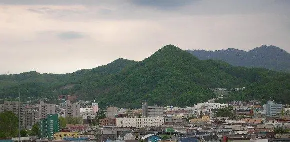
Mt. Sankakuyama is a 311-meter low peak in Yamanote, Nishi Ward, Sapporo, named for the triangular profile it presents when viewed from the surrounding city. A first-order triangulation station — Kotoni-yama — sits at the summit, and the mountain forms part of the Sapporo Sankakuyama–Bankei Nature Trail system with multiple trailheads on the Yamanote, Miyanomori, and Ōkurayama sides. Easily reached from the city, it is a year-round neighborhood peak and is included in the Sapporo 50 Peaks list.
Mt. Sankakuyama at a glance
- Weather: The most settled day in the next 7 days is Thu, November 5: clear, gusts up to 7 m/s. Sat, Nov 7, Sun, Nov 8: strong wind (gusts up to 17 m/s).
- Route: The shortest is Sapporo Loop from Yamanote up Mount Sankaku along the Nature Trail over Mount Okura and Mount Okusankaku: about 3 h 46 min, 6.2 km, about 520 m of climbing.
Mt. Sankakuyama weather (hourly, 14 days)
Sunrise today 06:11, sunset 16:26
| Tue, 11/3 | Wed, 11/4 | Thu, 11/5 | Fri, 11/6 | Sat, 11/7 | Sun, 11/8 | Mon, 11/9 | Tue, 11/10 | Wed, 11/11 | Thu, 11/12 | Fri, 11/13 | Sat, 11/14 | Sun, 11/15 | Mon, 11/16 | Tue, 11/17 | |||||||||||||||||||||||||||||||||||||||||||||||||||||||||||||||||||||||
|---|---|---|---|---|---|---|---|---|---|---|---|---|---|---|---|---|---|---|---|---|---|---|---|---|---|---|---|---|---|---|---|---|---|---|---|---|---|---|---|---|---|---|---|---|---|---|---|---|---|---|---|---|---|---|---|---|---|---|---|---|---|---|---|---|---|---|---|---|---|---|---|---|---|---|---|---|---|---|---|---|---|---|---|---|---|
| Japan time | 15 | 17 | 19 | 21 | 23 | 1 | 3 | 5 | 7 | 9 | 11 | 13 | 15 | 18 | 21 | 0 | 3 | 6 | 9 | 12 | 15 | 18 | 21 | 0 | 3 | 6 | 9 | 12 | 15 | 18 | 21 | 0 | 3 | 6 | 9 | 12 | 15 | 18 | 21 | 0 | 3 | 6 | 9 | 12 | 15 | 18 | 21 | 0 | 3 | 6 | 9 | 15 | 21 | 3 | 9 | 15 | 21 | 3 | 9 | 15 | 21 | 3 | 9 | 15 | 21 | 3 | 9 | 15 | 21 | 3 | 9 | 15 | 21 | 3 | 9 | 15 | 21 | 3 | 9 | 15 | 21 | 3 | 9 | 15 | |
  |   | |   |   |   | | | | |  | | |  | | | | |   | | |   |   |   | |   | | |   | | | |   | |   | | | | | | | | | | | | | | | | |   | | | | | |   |   | | | | | | | | | | | | | | | |   | | | |   | | | | | | ||
| Temperature | °C | 5° | 2° | 1° | 0° | 1° | 1° | 2° | 2° | 3° | 4° | 6° | 7° | 7° | 1° | 0° | -1° | 1° | 2° | 8° | 12° | 12° | 8° | 7° | 7° | 8° | 8° | 12° | 15° | 12° | 6° | 4° | 1° | 0° | -1° | 0° | 0° | 0° | -1° | -1° | -1° | -1° | -1° | -1° | 1° | 0° | 0° | -1° | -1° | -1° | -1° | 0° | 0° | -2° | -5° | 0° | 2° | -2° | -2° | 2° | 3° | -2° | -1° | 2° | 3° | 0° | -2° | -2° | -1° | 0° | -1° | 2° | 4° | -4° | 2° | 6° | 8° | 6° | 5° | 3° | 2° | 0° | -2° | 2° | 3° |
| Precipitation | mm | 0.7 | 2.1 | 1.1 | 3.0 | 1.6 | 1.6 | 0.5 | 0.5 | 0.4 | 0.8 | 0.7 | 0.9 | 0.9 | 1.0 | 0.7 | 0.8 | 0.8 | 0.7 | 0.7 | 0.9 | 0.7 | 0.4 | 0.2 | 0.1 | 0.7 | 0.6 | 0.1 | 0.5 | 0.4 | 0.6 | 0.9 | 1.2 | 1.2 | 0.1 | 1.0 | 4.0 | 2.6 | 0.5 | ||||||||||||||||||||||||||||||||||||||||||||||
| New snow | cm | <.1 | 0.4 | 1.5 | 0.6 | <.1 | 0.5 | 0.7 | 0.9 | 0.9 | 1.0 | 0.7 | 0.8 | 0.8 | 0.7 | 0.7 | 0.9 | 0.7 | 0.4 | 0.2 | 0.1 | <.1 | <.1 | <.1 | 0.7 | 0.6 | 0.1 | 0.3 | 0.4 | 0.6 | 0.9 | 1.2 | 1.2 | 0.3 | 0.9 | 0.5 | <.1 | ||||||||||||||||||||||||||||||||||||||||||||||||
| Snow depth | cm | 0 | 0 | 0 | 0 | <1 | 1 | 1 | 1 | 1 | 1 | 1 | 1 | 1 | 1 | <1 | <1 | <1 | <1 | <1 | <1 | <1 | <1 | 0 | 0 | 0 | 0 | 0 | 0 | 0 | 0 | 0 | <1 | <1 | 1 | 2 | 2 | 2 | 2 | 3 | 4 | 4 | 4 | 4 | 4 | 5 | 5 | 4 | 4 | 4 | 4 | 4 | 4 | 4 | 4 | 4 | 3 | 3 | 4 | 4 | 4 | 3 | 3 | 3 | 3 | 3 | 3 | 4 | 4 | 5 | 6 | 6 | 4 | 4 | 4 | 4 | 2 | 1 | <1 | <1 | 1 | 1 | 1 | 1 | 1 |
| Wind | m/s | 4 | 2 | 2 | 1 | 2 | 1 | 2 | 3 | 4 | 4 | 2 | 1 | 1 | 1 | 2 | 2 | 2 | 2 | 2 | 2 | 1 | 1 | 2 | 1 | 1 | 2 | 2 | 2 | 3 | 1 | 2 | 3 | 3 | 4 | 5 | 5 | 4 | 5 | 6 | 6 | 7 | 6 | 4 | 5 | 4 | 4 | 3 | 1 | 1 | 1 | 2 | 3 | 2 | 2 | 1 | 2 | 1 | 1 | 1 | 3 | 2 | 2 | 1 | 3 | 1 | 2 | 6 | 4 | 3 | 1 | 0 | 1 | 2 | 2 | 2 | 1 | 1 | 2 | 4 | 5 | 5 | 2 | 2 | 1 |
| Wind gusts | m/s | 12 | 11 | 7 | 6 | 8 | 9 | 7 | 9 | 11 | 13 | 12 | 6 | 5 | 4 | 6 | 7 | 7 | 7 | 6 | 7 | 7 | 4 | 5 | 6 | 5 | 6 | 7 | 9 | 11 | 11 | 7 | 12 | 11 | 12 | 13 | 15 | 16 | 15 | 18 | 18 | 19 | 19 | 17 | 15 | 15 | 12 | 11 | 8 | 6 | 4 | 7 | 11 | 8 | 5 | 6 | 6 | 6 | 3 | 4 | 8 | 7 | 6 | 4 | 10 | 8 | 5 | 15 | 15 | 11 | 8 | 5 | 4 | 5 | 6 | 7 | 7 | 6 | 6 | 9 | 14 | 15 | 12 | 7 | 7 |
| Wind dir. | ↓ | ↓ | ↓ | ↓ | ↓ | ↓ | ↓ | ↓ | ↓ | ↓ | ↓ | ↓ | ↓ | ↓ | ↓ | ↓ | ↓ | ↓ | ↓ | ↓ | ↓ | ↓ | ↓ | ↓ | ↓ | ↓ | ↓ | ↓ | ↓ | ↓ | ↓ | ↓ | ↓ | ↓ | ↓ | ↓ | ↓ | ↓ | ↓ | ↓ | ↓ | ↓ | ↓ | ↓ | ↓ | ↓ | ↓ | ↓ | ↓ | ↓ | ↓ | ↓ | ↓ | ↓ | ↓ | ↓ | ↓ | ↓ | ↓ | ↓ | ↓ | ↓ | ↓ | ↓ | ↓ | ↓ | ↓ | ↓ | ↓ | ↓ | ↓ | ↓ | ↓ | ↓ | ↓ | ↓ | ↓ | ↓ | ↓ | ↓ | ↓ | ↓ | ↓ | ↓ | |
Mt. Sankakuyama hiking routes
Hiking times are estimates calculated from the terrain.
Huts, campsites and lodging near Mt. Sankakuyama
Campsites
- Redoor Sapporo
- コモレビヨリ
Lodging
- ドミトリーS・Ⅱ
- Hotel Kotoni Sapporo
- Sapporo Hotel Yamachi
- Sapporo Maruyama Guesthouse Tsumuri-An
- 琴似グリーンホテル
Lists that include Mt. Sankakuyama
Mt. Sankakuyama facts
- Elevation
- 311 m
- Location
- Sapporo, Hokkaido
43.057495, 141.287135 - Website
- www.city.sapporo.jp
- Trail Map
- www.city.sapporo.jp (PDF)
- Wikipedia
- ja.wikipedia.org