
Mount Zenibako-tengu
銭函天狗山
Otaru, Hokkaido · Elevation 536 m
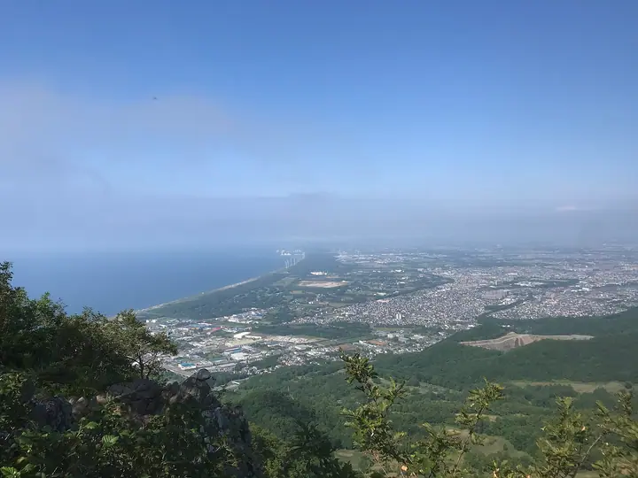
Mount Zenibako-tengu (536 m), affectionately known as "Zenten", rises in Miharashi-cho, Otaru City in Hokkaido, near the boundary with Sapporo City. Despite its modest height, the trail is steep with rope-assisted sections, and the summit commands sweeping views of Ishikari Bay, the Sapporo cityscape, and Mount Teine. It is listed in the Hokkaido Hyakumeizan (1993 edition).
Mount Zenibako-tengu at a glance
- Weather: The most settled day in the next 7 days is Thu, November 5: clear, gusts up to 6 m/s. Wed, Nov 4, Sat, Nov 7, Sun, Nov 8: strong wind (gusts up to 19 m/s).
- Route: The shortest is Mount Zenibako Tengu Return via Zenibako Trailhead: about 2 h 48 min, 5.0 km, about 490 m of climbing.
Mount Zenibako-tengu weather (hourly, 14 days)
Sunrise today 06:12, sunset 16:26
| Tue, 11/3 | Wed, 11/4 | Thu, 11/5 | Fri, 11/6 | Sat, 11/7 | Sun, 11/8 | Mon, 11/9 | Tue, 11/10 | Wed, 11/11 | Thu, 11/12 | Fri, 11/13 | Sat, 11/14 | Sun, 11/15 | Mon, 11/16 | Tue, 11/17 | |||||||||||||||||||||||||||||||||||||||||||||||||||||||||||||||||||||||
|---|---|---|---|---|---|---|---|---|---|---|---|---|---|---|---|---|---|---|---|---|---|---|---|---|---|---|---|---|---|---|---|---|---|---|---|---|---|---|---|---|---|---|---|---|---|---|---|---|---|---|---|---|---|---|---|---|---|---|---|---|---|---|---|---|---|---|---|---|---|---|---|---|---|---|---|---|---|---|---|---|---|---|---|---|---|
| Japan time | 15 | 17 | 19 | 21 | 23 | 1 | 3 | 5 | 7 | 9 | 11 | 13 | 15 | 18 | 21 | 0 | 3 | 6 | 9 | 12 | 15 | 18 | 21 | 0 | 3 | 6 | 9 | 12 | 15 | 18 | 21 | 0 | 3 | 6 | 9 | 12 | 15 | 18 | 21 | 0 | 3 | 6 | 9 | 12 | 15 | 18 | 21 | 0 | 3 | 6 | 9 | 15 | 21 | 3 | 9 | 15 | 21 | 3 | 9 | 15 | 21 | 3 | 9 | 15 | 21 | 3 | 9 | 15 | 21 | 3 | 9 | 15 | 21 | 3 | 9 | 15 | 21 | 3 | 9 | 15 | 21 | 3 | 9 | 15 | |
  |   | |   |   |   |   | | | |  | | |  | | | | | |   | |   |   |   | |   | | |   |   | | |   | |   |   |   |   | | | | | | | | | | | | | | | | | | | | | |   | | | |   | | | | | | | | | | | | | | |   | | | | | | ||
| Temperature | °C | 3° | 1° | 1° | 0° | 0° | -2° | 1° | 2° | 2° | 2° | 3° | 4° | 4° | 0° | 0° | 0° | 1° | 2° | 7° | 10° | 10° | 6° | 6° | 6° | 6° | 7° | 10° | 12° | 8° | 4° | 1° | -1° | -2° | -2° | -2° | -2° | -2° | -3° | -2° | -3° | -3° | -3° | -2° | -1° | -1° | -2° | -2° | -2° | -3° | -2° | -2° | -2° | -3° | -5° | -1° | -1° | -2° | -3° | 0° | 1° | -1° | -1° | 1° | 1° | -1° | -2° | -3° | -2° | -1° | -1° | 1° | 3° | -2° | 2° | 6° | 7° | 5° | 4° | 2° | 0° | -1° | -2° | 0° | 1° |
| Precipitation | mm | 0.9 | 3.8 | 1.5 | 1.7 | 3.1 | 1.5 | 1.1 | 0.4 | 0.4 | 1.1 | 1.0 | 0.8 | 0.9 | 0.9 | 0.7 | 0.7 | 0.8 | 0.6 | 0.6 | 0.7 | 0.6 | 0.3 | 0.1 | 0.5 | 0.2 | 0.2 | 0.2 | 0.6 | 1.2 | 0.9 | 1.1 | 1.4 | 0.9 | 2.2 | 6 | 2.6 | 0.6 | |||||||||||||||||||||||||||||||||||||||||||||||
| New snow | cm | <.1 | 0.7 | 3.0 | 0.8 | <.1 | 0.6 | 0.9 | 0.8 | 0.9 | 0.9 | 0.6 | 0.7 | 0.7 | 0.6 | 0.6 | 0.7 | 0.6 | 0.2 | <.1 | <.1 | <.1 | <.1 | <.1 | 0.5 | 0.2 | 0.2 | 0.3 | <.1 | 1.2 | 0.9 | 1.1 | 0.9 | 0.4 | 0.1 | 0.8 | 0.5 | ||||||||||||||||||||||||||||||||||||||||||||||||
| Snow depth | cm | <1 | <1 | 0 | <1 | <1 | 2 | 3 | 3 | 2 | 2 | 2 | 1 | <1 | <1 | <1 | <1 | <1 | <1 | <1 | <1 | 0 | 0 | 0 | 0 | 0 | 0 | 0 | 0 | 0 | 0 | 0 | <1 | <1 | 1 | 1 | 2 | 2 | 2 | 2 | 2 | 2 | 2 | 2 | 2 | 2 | 2 | 2 | 2 | 2 | 2 | 2 | 2 | 2 | 2 | 2 | 2 | 2 | 2 | 2 | 2 | 2 | 2 | 2 | 2 | 2 | 2 | 2 | 3 | 3 | 3 | 3 | 3 | 3 | 2 | 1 | <1 | <1 | 0 | 0 | <1 | <1 | <1 | <1 | <1 |
| Wind | m/s | 6 | 5 | 4 | 3 | 2 | 0 | 3 | 6 | 7 | 7 | 4 | 2 | 2 | 2 | 2 | 3 | 3 | 3 | 3 | 3 | 2 | 2 | 2 | 1 | 2 | 2 | 1 | 1 | 6 | 6 | 5 | 7 | 7 | 8 | 8 | 8 | 8 | 9 | 9 | 9 | 9 | 9 | 8 | 9 | 8 | 7 | 6 | 4 | 4 | 5 | 5 | 5 | 4 | 3 | 2 | 2 | 2 | 0 | 0 | 4 | 3 | 3 | 2 | 5 | 5 | 5 | 8 | 7 | 5 | 3 | 2 | 1 | 2 | 2 | 3 | 1 | 2 | 5 | 5 | 7 | 7 | 6 | 4 | 4 |
| Wind gusts | m/s | 14 | 13 | 9 | 9 | 7 | 8 | 8 | 13 | 15 | 16 | 14 | 8 | 6 | 5 | 5 | 7 | 7 | 7 | 6 | 6 | 6 | 4 | 4 | 5 | 6 | 6 | 5 | 5 | 12 | 15 | 13 | 17 | 17 | 17 | 17 | 19 | 19 | 19 | 20 | 19 | 19 | 19 | 19 | 19 | 18 | 15 | 13 | 12 | 9 | 10 | 11 | 12 | 11 | 8 | 7 | 7 | 6 | 5 | 3 | 9 | 8 | 7 | 6 | 12 | 11 | 10 | 16 | 17 | 15 | 10 | 7 | 6 | 5 | 6 | 7 | 7 | 6 | 9 | 11 | 15 | 16 | 14 | 11 | 9 |
| Wind dir. | ↓ | ↓ | ↓ | ↓ | ↓ | ↓ | ↓ | ↓ | ↓ | ↓ | ↓ | ↓ | ↓ | ↓ | ↓ | ↓ | ↓ | ↓ | ↓ | ↓ | ↓ | ↓ | ↓ | ↓ | ↓ | ↓ | ↓ | ↓ | ↓ | ↓ | ↓ | ↓ | ↓ | ↓ | ↓ | ↓ | ↓ | ↓ | ↓ | ↓ | ↓ | ↓ | ↓ | ↓ | ↓ | ↓ | ↓ | ↓ | ↓ | ↓ | ↓ | ↓ | ↓ | ↓ | ↓ | ↓ | ↓ | ↓ | ↓ | ↓ | ↓ | ↓ | ↓ | ↓ | ↓ | ↓ | ↓ | ↓ | ↓ | ↓ | ↓ | ↓ | ↓ | ↓ | ↓ | ↓ | ↓ | ↓ | ↓ | ↓ | ↓ | ↓ | ↓ | ↓ | |
Mount Zenibako-tengu hiking routes
Hiking times are estimates calculated from the terrain.
Huts, campsites and lodging near Mount Zenibako-tengu
Mountain huts
Lodging
- OTARO Village
- 民宿 慶成
- 民宿 まつよ
- 小さな旅の博物館
Mount Zenibako-tengu facts
- Also known as
- 銭天
- Elevation
- 536 m
- Location
- Otaru, Hokkaido
43.121363, 141.162820 - Website
- otaru.gr.jp
- Wikipedia
- ja.wikipedia.org