
Mt. Subaridake
スバリ岳
Tateyama, Toyama · Elevation 2,752 m
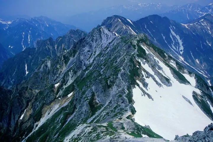
Mt. Subaridake is a 2,752 m peak on the Toyama-Nagano prefectural border between Tateyama Town and Ōmachi City, lying within Chūbu-Sangaku National Park on the main ridge of the Ushiro-Tateyama Range just north of Mt. Harinoki and overlooking the east shore of Lake Kurobe. A subsidiary pinnacle to the north is known as Ko-Subari, and the name is said to derive either from the "narrowing" of the deep valleys below or from the rocky face on which alpine accentors (iwa-hibari) build nests. Climbers reach it from Ōgisawa via the Harinoki Snow Gully, Harinoki Pass and Mt. Harinoki, often as part of a multi-day traverse continuing over Mts. Akasawa, Narusawa, Iwakoyazawa, Jīgatake and back along the Kashiwabara trail; the peak is listed among the Japan Top 100 High Mountains.
Mt. Subaridake at a glance
- Weather: The most settled day in the next 7 days is Wed, November 4: clear, gusts up to 7 m/s. Fri, Nov 6, Sat, Nov 7: strong wind (gusts up to 20 m/s).
Mt. Subaridake weather (hourly, 14 days)
Sunrise today 06:14, sunset 16:52
| Tue, 11/3 | Wed, 11/4 | Thu, 11/5 | Fri, 11/6 | Sat, 11/7 | Sun, 11/8 | Mon, 11/9 | Tue, 11/10 | Wed, 11/11 | Thu, 11/12 | Fri, 11/13 | Sat, 11/14 | Sun, 11/15 | Mon, 11/16 | Tue, 11/17 | |||||||||||||||||||||||||||||||||||||||||||||||||||||||||||||||||||||||
|---|---|---|---|---|---|---|---|---|---|---|---|---|---|---|---|---|---|---|---|---|---|---|---|---|---|---|---|---|---|---|---|---|---|---|---|---|---|---|---|---|---|---|---|---|---|---|---|---|---|---|---|---|---|---|---|---|---|---|---|---|---|---|---|---|---|---|---|---|---|---|---|---|---|---|---|---|---|---|---|---|---|---|---|---|---|
| Japan time | 21 | 23 | 1 | 3 | 5 | 7 | 9 | 11 | 13 | 15 | 17 | 19 | 21 | 0 | 3 | 6 | 9 | 12 | 15 | 18 | 21 | 0 | 3 | 6 | 9 | 12 | 15 | 18 | 21 | 0 | 3 | 6 | 9 | 12 | 15 | 18 | 21 | 0 | 3 | 6 | 9 | 12 | 15 | 18 | 21 | 0 | 3 | 6 | 9 | 12 | 15 | 21 | 3 | 9 | 15 | 21 | 3 | 9 | 15 | 21 | 3 | 9 | 15 | 21 | 3 | 9 | 15 | 21 | 3 | 9 | 15 | 21 | 3 | 9 | 15 | 21 | 3 | 9 | 15 | 21 | 3 | 9 | 15 | 21 | |
  | | | |  |   |  | | | |   |   | |   | | |   |   | | | | | | | | | |   |   | | | |   | | | | | | |   | | |   | | | | | | | | | |   | | | | | | |   |  | | | | | |   | | | | | | | | | | | |   | | | | | | ||
| Temperature | °C | -11° | -10° | -9° | -8° | -9° | -7° | 0° | 3° | 4° | 3° | -1° | -2° | -2° | -1° | -1° | 0° | 3° | 6° | 4° | 2° | 1° | 1° | 0° | -1° | -1° | -1° | -2° | -5° | -6° | -7° | -9° | -10° | -10° | -9° | -10° | -12° | -13° | -14° | -14° | -13° | -6° | -3° | -4° | -9° | -8° | -6° | -5° | -4° | -3° | -3° | -5° | -14° | -15° | -4° | -3° | -7° | -12° | -10° | -9° | -11° | -14° | -6° | -5° | -14° | -8° | -7° | -6° | -13° | -13° | -2° | -1° | -11° | -10° | 0° | -1° | -1° | -2° | -1° | -5° | -10° | -12° | -4° | -3° | -10° |
| Precipitation | mm | 3.6 | 9 | 5.0 | 0.1 | 1.0 | 0.2 | 2.1 | 10 | 4.8 | 1.2 | 1.9 | 1.4 | 3.4 | 2.6 | 2.6 | 2.9 | 2.9 | 2.5 | 2.3 | 1.4 | 0.4 | 0.2 | 0.1 | 0.1 | 4.9 | 11 | 8 | 2.7 | 2.4 | 5 | 0.3 | 0.7 | 8 | 8 | 6 | 9 | 4.2 | |||||||||||||||||||||||||||||||||||||||||||||||
| New snow | cm | 0.9 | 2.1 | 2.4 | 2.6 | 2.8 | 2.5 | 2.3 | 1.4 | 0.4 | 0.2 | <.1 | <.1 | <.1 | <.1 | 0.6 | <.1 | 4.8 | 10 | 8.2 | 2.7 | <.1 | 2.3 | 4.7 | 0.3 | 2.1 | 3.3 | ||||||||||||||||||||||||||||||||||||||||||||||||||||||||||
| Snow depth | cm | 0 | 0 | 0 | 0 | 0 | 0 | 0 | 0 | 0 | 0 | 0 | 0 | 0 | 0 | 0 | 0 | 0 | 0 | 0 | 0 | 0 | 0 | 0 | 0 | 0 | 0 | 0 | 0 | <1 | 4 | 6 | 9 | 12 | 13 | 14 | 14 | 13 | 13 | 13 | 12 | 12 | 12 | 11 | 11 | 11 | 11 | 12 | 14 | 14 | 14 | 12 | 12 | 12 | 12 | 11 | 14 | 23 | 29 | 30 | 29 | 28 | 28 | 27 | 26 | 28 | 31 | 30 | 30 | 29 | 29 | 28 | 28 | 28 | 27 | 25 | 24 | 22 | 20 | 19 | 21 | 20 | 20 | 20 | 19 |
| Wind | m/s | 1 | 1 | 1 | 0 | 0 | 1 | 1 | 0 | 1 | 1 | 1 | 1 | 1 | 0 | 0 | 2 | 2 | 2 | 1 | 1 | 2 | 3 | 2 | 3 | 3 | 4 | 3 | 4 | 3 | 3 | 3 | 4 | 4 | 5 | 4 | 3 | 2 | 2 | 1 | 1 | 1 | 1 | 0 | 1 | 1 | 1 | 1 | 2 | 2 | 2 | 1 | 1 | 1 | 1 | 2 | 3 | 7 | 4 | 2 | 1 | 1 | 1 | 1 | 1 | 2 | 2 | 1 | 1 | 1 | 1 | 0 | 1 | 1 | 1 | 1 | 2 | 2 | 1 | 3 | 1 | 0 | 0 | 0 | 0 |
| Wind gusts | m/s | 8 | 8 | 7 | 6 | 6 | 5 | 6 | 6 | 7 | 7 | 6 | 7 | 8 | 8 | 6 | 12 | 12 | 10 | 10 | 9 | 11 | 15 | 15 | 13 | 15 | 18 | 20 | 18 | 18 | 16 | 14 | 17 | 18 | 19 | 20 | 18 | 14 | 12 | 11 | 11 | 9 | 7 | 7 | 7 | 9 | 11 | 12 | 13 | 13 | 13 | 12 | 8 | 7 | 7 | 12 | 14 | 28 | 30 | 19 | 11 | 6 | 7 | 9 | 7 | 11 | 11 | 11 | 9 | 8 | 6 | 6 | 6 | 8 | 9 | 13 | 15 | 18 | 14 | 15 | 14 | 7 | 4 | 5 | 6 |
| Wind dir. | ↓ | ↓ | ↓ | ↓ | ↓ | ↓ | ↓ | ↓ | ↓ | ↓ | ↓ | ↓ | ↓ | ↓ | ↓ | ↓ | ↓ | ↓ | ↓ | ↓ | ↓ | ↓ | ↓ | ↓ | ↓ | ↓ | ↓ | ↓ | ↓ | ↓ | ↓ | ↓ | ↓ | ↓ | ↓ | ↓ | ↓ | ↓ | ↓ | ↓ | ↓ | ↓ | ↓ | ↓ | ↓ | ↓ | ↓ | ↓ | ↓ | ↓ | ↓ | ↓ | ↓ | ↓ | ↓ | ↓ | ↓ | ↓ | ↓ | ↓ | ↓ | ↓ | ↓ | ↓ | ↓ | ↓ | ↓ | ↓ | ↓ | ↓ | ↓ | ↓ | ↓ | ↓ | ↓ | ↓ | ↓ | ↓ | ↓ | ↓ | ↓ | ↓ | ↓ | ↓ | |
Huts, campsites and lodging near Mt. Subaridake
Mountain huts
- Harinoki Lodge 2026: open July 1–September 27 · reservation required · sleeps 60
- Osawa Goya reservation required
- Lodge Kuroyon 2026: open May 15–October 25 · reservation required · sleeps 100
- Shinkoshi-Sanso 2026: open July 15–September 26 · reservation required · sleeps 35
- 船窪小屋
Campsites
- 針ノ木小屋テント場
- Kurojon
- 船窪小屋テント場
Lists that include Mt. Subaridake
Japan's 100 Highest Mountains · Elevations of 1003 Mountains of Japan
Mt. Subaridake facts
- Elevation
- 2,752 m
- Location
- Tateyama, Toyama
36.544355, 137.684848 - National Park
- 中部山岳国立公園
- Website
- kanko-omachi.gr.jp
- Access Information
- kanko-omachi.gr.jp
- Wikipedia
- ja.wikipedia.org