
Mt. Shirouma-Yarigatake
鑓ヶ岳
Hakuba, Nagano · Elevation 2,903 m
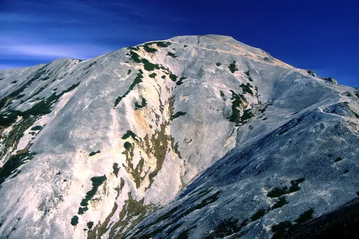
Mt. Shirouma-Yarigatake is a 2,903 m peak in the Ushiro-Tateyama Range of the Hida Mountains (Northern Alps), straddling Kurobe in Toyama and Hakuba in Nagano Prefecture, and forming the southernmost — and second-highest — summit of the Hakuba Sanzan trio with Mt. Shirouma-dake and Mt. Shakushidake. Its sharp andesite dome rises within Chūbu-Sangaku National Park above the popular Shirouma-yari Onsen and the main ridge traverse. The peak is featured in Nihon Hyaku-Kōzan, Toyama no Hyakuzan, Kōshin'etsu Hyakumeizan, Nihon 2500-Meter Peaks, and Hakuba Sanzan.
Mt. Shirouma-Yarigatake at a glance
- Weather: The most settled day in the next 7 days is Wed, November 4: clear, gusts up to 9 m/s. Fri, Nov 6, Sat, Nov 7: strong wind (gusts up to 18 m/s).
Mt. Shirouma-Yarigatake weather (hourly, 14 days)
Sunrise today 06:14, sunset 16:51
| Tue, 11/3 | Wed, 11/4 | Thu, 11/5 | Fri, 11/6 | Sat, 11/7 | Sun, 11/8 | Mon, 11/9 | Tue, 11/10 | Wed, 11/11 | Thu, 11/12 | Fri, 11/13 | Sat, 11/14 | Sun, 11/15 | Mon, 11/16 | Tue, 11/17 | |||||||||||||||||||||||||||||||||||||||||||||||||||||||||||||||||||||||
|---|---|---|---|---|---|---|---|---|---|---|---|---|---|---|---|---|---|---|---|---|---|---|---|---|---|---|---|---|---|---|---|---|---|---|---|---|---|---|---|---|---|---|---|---|---|---|---|---|---|---|---|---|---|---|---|---|---|---|---|---|---|---|---|---|---|---|---|---|---|---|---|---|---|---|---|---|---|---|---|---|---|---|---|---|---|
| Japan time | 15 | 17 | 19 | 21 | 23 | 1 | 3 | 5 | 7 | 9 | 11 | 13 | 15 | 18 | 21 | 0 | 3 | 6 | 9 | 12 | 15 | 18 | 21 | 0 | 3 | 6 | 9 | 12 | 15 | 18 | 21 | 0 | 3 | 6 | 9 | 12 | 15 | 18 | 21 | 0 | 3 | 6 | 9 | 12 | 15 | 18 | 21 | 0 | 3 | 6 | 9 | 15 | 21 | 3 | 9 | 15 | 21 | 3 | 9 | 15 | 21 | 3 | 9 | 15 | 21 | 3 | 9 | 15 | 21 | 3 | 9 | 15 | 21 | 3 | 9 | 15 | 21 | 3 | 9 | 15 | 21 | 3 | 9 | 15 | |
  |  |   | | |   | | |  | | |   | |   | |   | | |   |   | | | | | | | | | | |   | |   | |   | | | | | | | | | | | | | | | | | | | | | | | | | | | | | | | | | | |  | | | | | | | | | |   | | | | | ||
| Temperature | °C | 0° | -3° | -7° | -9° | -10° | -10° | -9° | -7° | -5° | 0° | 3° | 4° | 4° | -1° | -1° | -1° | -1° | 0° | 2° | 6° | 7° | 3° | 2° | 2° | 2° | 1° | 2° | 2° | 1° | -2° | -3° | -5° | -6° | -8° | -8° | -8° | -8° | -9° | -11° | -12° | -13° | -13° | -6° | -3° | -5° | -7° | -8° | -7° | -7° | -6° | -2° | -4° | -7° | -11° | -3° | 0° | -5° | -10° | -8° | -7° | -9° | -11° | -5° | -4° | -12° | -7° | -6° | -6° | -11° | -16° | -3° | 0° | -8° | -8° | 1° | 1° | -1° | -1° | -1° | -3° | -7° | -10° | -5° | -3° |
| Precipitation | mm | 1.0 | 10 | 9 | 5.0 | 2.0 | 0.2 | 1.8 | 0.1 | 1.0 | 3.4 | 2.3 | 2.4 | 1.0 | 2.4 | 2.5 | 3.7 | 3.4 | 3.7 | 3.6 | 1.9 | 1.9 | 1.2 | 0.2 | 0.2 | 0.4 | 1.7 | 1.9 | 0.3 | 6 | 13 | 11 | 6 | 1.0 | 2.4 | 9 | 1.0 | 0.1 | 0.3 | 8 | 7 | 10 | 13 | 3.5 | 0.1 | ||||||||||||||||||||||||||||||||||||||||
| New snow | cm | 0.5 | 2.5 | 2.8 | 3.4 | 3.6 | 1.9 | 1.9 | 1.2 | 0.2 | <.1 | <.1 | <.1 | <.1 | 0.4 | 1.5 | 1.5 | <.1 | <.1 | 4.4 | 12 | 11 | 6.1 | 1.0 | 2.2 | 8.2 | 1.0 | <.1 | 0.1 | 1.1 | <.1 | ||||||||||||||||||||||||||||||||||||||||||||||||||||||
| Snow depth | cm | 0 | 0 | 0 | 0 | 0 | 0 | 0 | 0 | 0 | 0 | 0 | 0 | 0 | 0 | 0 | 0 | 0 | 0 | 0 | 0 | 0 | 0 | 0 | 0 | 0 | 0 | 0 | 0 | 0 | 0 | <1 | 2 | 4 | 6 | 9 | 10 | 10 | 11 | 11 | 11 | 11 | 11 | 10 | 10 | 9 | 9 | 9 | 9 | 10 | 11 | 11 | 9 | 8 | 8 | 8 | 6 | 9 | 18 | 26 | 28 | 28 | 27 | 26 | 24 | 23 | 25 | 30 | 30 | 29 | 28 | 28 | 26 | 26 | 25 | 25 | 22 | 21 | 20 | 18 | 15 | 16 | 15 | 15 | 13 |
| Wind | m/s | 1 | 0 | 1 | 1 | 1 | 1 | 0 | 0 | 1 | 2 | 1 | 1 | 2 | 1 | 2 | 2 | 2 | 1 | 1 | 0 | 1 | 0 | 1 | 1 | 1 | 1 | 2 | 2 | 2 | 2 | 2 | 2 | 2 | 2 | 2 | 2 | 2 | 2 | 1 | 1 | 1 | 1 | 1 | 1 | 0 | 1 | 1 | 1 | 1 | 1 | 1 | 1 | 1 | 1 | 1 | 2 | 2 | 4 | 3 | 2 | 0 | 1 | 1 | 1 | 1 | 1 | 2 | 2 | 0 | 0 | 0 | 0 | 1 | 0 | 0 | 0 | 1 | 1 | 1 | 2 | 1 | 0 | 0 | 0 |
| Wind gusts | m/s | 10 | 9 | 8 | 9 | 8 | 8 | 7 | 6 | 7 | 8 | 9 | 7 | 7 | 10 | 12 | 13 | 11 | 10 | 11 | 12 | 12 | 11 | 9 | 10 | 10 | 11 | 13 | 15 | 18 | 17 | 17 | 16 | 17 | 17 | 16 | 18 | 18 | 16 | 14 | 13 | 13 | 12 | 11 | 10 | 10 | 10 | 10 | 10 | 10 | 11 | 11 | 11 | 8 | 6 | 8 | 13 | 17 | 27 | 28 | 20 | 14 | 7 | 8 | 10 | 10 | 11 | 12 | 12 | 11 | 8 | 6 | 7 | 7 | 7 | 8 | 11 | 17 | 17 | 15 | 18 | 17 | 9 | 6 | 6 |
| Wind dir. | ↓ | ↓ | ↓ | ↓ | ↓ | ↓ | ↓ | ↓ | ↓ | ↓ | ↓ | ↓ | ↓ | ↓ | ↓ | ↓ | ↓ | ↓ | ↓ | ↓ | ↓ | ↓ | ↓ | ↓ | ↓ | ↓ | ↓ | ↓ | ↓ | ↓ | ↓ | ↓ | ↓ | ↓ | ↓ | ↓ | ↓ | ↓ | ↓ | ↓ | ↓ | ↓ | ↓ | ↓ | ↓ | ↓ | ↓ | ↓ | ↓ | ↓ | ↓ | ↓ | ↓ | ↓ | ↓ | ↓ | ↓ | ↓ | ↓ | ↓ | ↓ | ↓ | ↓ | ↓ | ↓ | ↓ | ↓ | ↓ | ↓ | ↓ | ↓ | ↓ | ↓ | ↓ | ↓ | ↓ | ↓ | ↓ | ↓ | ↓ | ↓ | ↓ | ↓ | ↓ | |
Huts, campsites and lodging near Mt. Shirouma-Yarigatake
Mountain huts
- Tengu Sanso 2026: open July 1–September 23 · reservation required · sleeps 90
- 白馬鑓温泉小屋 2026: open July 11–September 27 · reservation required
- 緊急避難小屋
- Shiroumadake Chojoshukusha 2026: open June 27–September 27 · reservation required · sleeps 280
- Hakuba Sanso 2026: open April 25–October 12 · reservation required · sleeps 800
Campsites
- 白馬岳頂上宿舎テント場
Lists that include Mt. Shirouma-Yarigatake
Japan's 100 Highest Mountains · Koshinetsu 100 Famous Mountains · 100 Mountains of Toyama · 3 Mountains of Hakuba · Elevations of 1003 Mountains of Japan · 1000 Mountains of Japan
Mt. Shirouma-Yarigatake facts
- Also known as
- 白馬鑓ヶ岳
- Elevation
- 2,903 m
- Location
- Hakuba, Nagano
36.731326, 137.755369 - National Park
- 中部山岳国立公園
- Website
- hakubakan.com
- Access Information
- hakubakan.com
- Wikipedia
- ja.wikipedia.org