
Mt. Shakujodake
錫杖岳
Takayama, Gifu · Elevation 2,168 m
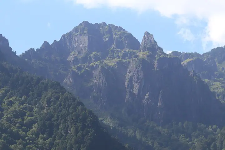
Shakujodake is a 2,168 m rock peak in the Hida Mountains (Northern Alps) within Takayama City, Gifu Prefecture, lying within the special zone of Chubusangaku National Park on a subsidiary ridge of Mt. Kasagatake. Its name comes from the resemblance of its sheer columnar-jointed cliffs to the head of a Buddhist shakujo staff. The Zenei-heki and Eboshi-iwa faces are renowned alpine rock-climbing objectives; no general hiking trail is maintained. The peak is included in numerous Gifu mountain lists, including Gifu Hyakuzan, Hida Hyakuzan, and Gifu Hyakushūzan.
Mt. Shakujodake at a glance
- Weather: The most settled day in the next 7 days is Wed, November 4: clear, gusts up to 7 m/s. Fri, Nov 6, Sat, Nov 7: strong wind (gusts up to 19 m/s).
Mt. Shakujodake weather (hourly, 14 days)
Sunrise today 06:14, sunset 16:53
| Tue, 11/3 | Wed, 11/4 | Thu, 11/5 | Fri, 11/6 | Sat, 11/7 | Sun, 11/8 | Mon, 11/9 | Tue, 11/10 | Wed, 11/11 | Thu, 11/12 | Fri, 11/13 | Sat, 11/14 | Sun, 11/15 | Mon, 11/16 | Tue, 11/17 | |||||||||||||||||||||||||||||||||||||||||||||||||||||||||||||||||||||||
|---|---|---|---|---|---|---|---|---|---|---|---|---|---|---|---|---|---|---|---|---|---|---|---|---|---|---|---|---|---|---|---|---|---|---|---|---|---|---|---|---|---|---|---|---|---|---|---|---|---|---|---|---|---|---|---|---|---|---|---|---|---|---|---|---|---|---|---|---|---|---|---|---|---|---|---|---|---|---|---|---|---|---|---|---|---|
| Japan time | 15 | 17 | 19 | 21 | 23 | 1 | 3 | 5 | 7 | 9 | 11 | 13 | 15 | 18 | 21 | 0 | 3 | 6 | 9 | 12 | 15 | 18 | 21 | 0 | 3 | 6 | 9 | 12 | 15 | 18 | 21 | 0 | 3 | 6 | 9 | 12 | 15 | 18 | 21 | 0 | 3 | 6 | 9 | 12 | 15 | 18 | 21 | 0 | 3 | 6 | 9 | 15 | 21 | 3 | 9 | 15 | 21 | 3 | 9 | 15 | 21 | 3 | 9 | 15 | 21 | 3 | 9 | 15 | 21 | 3 | 9 | 15 | 21 | 3 | 9 | 15 | 21 | 3 | 9 | 15 | 21 | 3 | 9 | 15 | |
  |   |   | | | | | | | |  | |   |   | |   | | |   | | | | | | | |   |   | | |   | |   |   |   |   | | | | | |  | | | | | | | | | | | | | | | | | |   | |  | | | | |   | | | | | | | | | | | | | |   | | | | ||
| Temperature | °C | 2° | -2° | -5° | -6° | -6° | -5° | -4° | -4° | -3° | 3° | 6° | 6° | 5° | 2° | 2° | 2° | 2° | 2° | 4° | 7° | 7° | 4° | 3° | 2° | 2° | 2° | 3° | 4° | 3° | -1° | -3° | -4° | -5° | -6° | -5° | -5° | -6° | -7° | -8° | -8° | -10° | -9° | -1° | 1° | 0° | -5° | -4° | -3° | -3° | -3° | -1° | 0° | -7° | -8° | -1° | -1° | -4° | -9° | -7° | -5° | -10° | -9° | -2° | -2° | -9° | -5° | -4° | -2° | -9° | -6° | 0° | 1° | -5° | -4° | 2° | 1° | 1° | 1° | 2° | 0° | -5° | -5° | -2° | 0° |
| Precipitation | mm | 2.9 | 10 | 8 | 5 | 0.4 | 0.3 | 3.0 | 2.8 | 0.6 | 1.0 | 0.2 | 0.1 | 0.2 | 0.7 | 0.8 | 0.8 | 0.7 | 0.2 | 0.2 | 0.3 | 0.2 | 4.1 | 6 | 2.2 | 0.2 | 0.2 | 1.6 | 0.5 | 8 | 8 | 4.7 | 1.3 | 0.4 | |||||||||||||||||||||||||||||||||||||||||||||||||||
| New snow | cm | <.1 | 0.1 | 0.4 | 0.8 | 0.8 | 0.7 | 0.2 | <.1 | <.1 | <.1 | 0.1 | 0.1 | <.1 | 0.1 | <.1 | 3.3 | 5.2 | 2.1 | 0.2 | 0.2 | 1.2 | <.1 | <.1 | <.1 | ||||||||||||||||||||||||||||||||||||||||||||||||||||||||||||
| Snow depth | cm | 0 | 0 | 0 | 0 | 0 | 0 | 0 | 0 | 0 | 0 | 0 | 0 | 0 | 0 | 0 | 0 | 0 | 0 | 0 | 0 | 0 | 0 | 0 | 0 | 0 | 0 | 0 | 0 | 0 | 0 | 0 | <1 | <1 | <1 | 2 | 2 | 2 | 2 | 2 | 2 | 2 | 2 | 1 | 1 | <1 | <1 | <1 | <1 | <1 | <1 | <1 | <1 | <1 | <1 | <1 | <1 | 3 | 7 | 8 | 7 | 7 | 7 | 7 | 6 | 6 | 6 | 7 | 6 | 6 | 6 | 6 | 5 | 5 | 5 | 4 | 3 | 2 | 2 | <1 | <1 | <1 | <1 | <1 | <1 |
| Wind | m/s | 3 | 0 | 1 | 1 | 1 | 1 | 0 | 1 | 1 | 1 | 1 | 2 | 2 | 1 | 2 | 1 | 2 | 0 | 1 | 1 | 2 | 0 | 0 | 1 | 1 | 2 | 4 | 5 | 5 | 3 | 4 | 5 | 5 | 5 | 5 | 5 | 4 | 3 | 2 | 1 | 1 | 1 | 1 | 2 | 1 | 1 | 0 | 0 | 1 | 1 | 1 | 2 | 1 | 2 | 2 | 5 | 2 | 6 | 3 | 2 | 0 | 0 | 1 | 2 | 1 | 1 | 2 | 2 | 0 | 0 | 1 | 1 | 0 | 0 | 1 | 1 | 2 | 1 | 3 | 4 | 1 | 0 | 1 | 1 |
| Wind gusts | m/s | 10 | 9 | 4 | 4 | 4 | 4 | 4 | 3 | 3 | 5 | 7 | 7 | 7 | 7 | 8 | 8 | 7 | 7 | 9 | 9 | 10 | 9 | 6 | 7 | 8 | 9 | 13 | 16 | 16 | 15 | 14 | 16 | 17 | 18 | 18 | 19 | 18 | 14 | 12 | 10 | 9 | 9 | 8 | 9 | 9 | 6 | 5 | 7 | 9 | 9 | 7 | 12 | 8 | 6 | 7 | 16 | 14 | 23 | 21 | 16 | 9 | 4 | 6 | 8 | 7 | 9 | 11 | 10 | 8 | 6 | 5 | 6 | 4 | 6 | 6 | 12 | 13 | 16 | 11 | 16 | 14 | 6 | 4 | 7 |
| Wind dir. | ↓ | ↓ | ↓ | ↓ | ↓ | ↓ | ↓ | ↓ | ↓ | ↓ | ↓ | ↓ | ↓ | ↓ | ↓ | ↓ | ↓ | ↓ | ↓ | ↓ | ↓ | ↓ | ↓ | ↓ | ↓ | ↓ | ↓ | ↓ | ↓ | ↓ | ↓ | ↓ | ↓ | ↓ | ↓ | ↓ | ↓ | ↓ | ↓ | ↓ | ↓ | ↓ | ↓ | ↓ | ↓ | ↓ | ↓ | ↓ | ↓ | ↓ | ↓ | ↓ | ↓ | ↓ | ↓ | ↓ | ↓ | ↓ | ↓ | ↓ | ↓ | ↓ | ↓ | ↓ | ↓ | ↓ | ↓ | ↓ | ↓ | ↓ | ↓ | ↓ | ↓ | ↓ | ↓ | ↓ | ↓ | ↓ | ↓ | ↓ | ↓ | ↓ | ↓ | ↓ | |
Huts, campsites and lodging near Mt. Shakujodake
Mountain huts
- 笠ヶ岳山荘 2026: open July 10–October 11 · reservation required · sleeps 100
- Hotakataira Goya 2026: open July 25–October 5 · sleeps 30
Campsites
- 合掌の森中尾キャンプ場
- 笠ヶ岳テント場
Lodging
- 槍見の湯 槍見館
- 新穂高温泉 深山荘
- ホテル穂高
- 野の花山荘
- お宿かみたから荘
Lists that include Mt. Shakujodake
100 Mountains of Gifu · Elevations of 1003 Mountains of Japan · 1000 Mountains of Japan
Mt. Shakujodake facts
- Elevation
- 2,168 m
- Location
- Takayama, Gifu
36.281921, 137.547219 - National Park
- 中部山岳国立公園
- Website
- hidasanmyaku-gifu.jp
- Wikipedia
- ja.wikipedia.org