
Mt. Kotaroyama
小太郎山
Minami-Alps, Yamanashi · Elevation 2,725 m
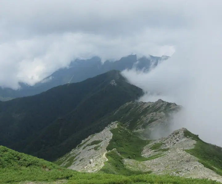
Mount Kotaroyama (2,725 m) is a quieter peak at the northern end of the Shirane Range in Minami-Alps City, Yamanashi, within South Alps National Park. Spurring off the main ridge north of Mount Kita, it gazes across the deep Nogawa valley to Mount Kita, Mount Sen-jō and the Hōō Sanzan. The name ("little Tarō") plays on the giant neighbouring Mount Kita, and most climbers reach it as a side detour from the Kotaro-ridge junction. The peak is listed in the Yamanashi 100 and Japan 100 High Mountains selections.
Mt. Kotaroyama at a glance
- Weather: The most settled day in the next 7 days is Sun, November 8: clear, gusts up to 9 m/s. Sat, Nov 7, Mon, Nov 9: strong wind (gusts up to 17 m/s).
Mt. Kotaroyama weather (hourly, 14 days)
Sunrise today 06:10, sunset 16:51
| Tue, 11/3 | Wed, 11/4 | Thu, 11/5 | Fri, 11/6 | Sat, 11/7 | Sun, 11/8 | Mon, 11/9 | Tue, 11/10 | Wed, 11/11 | Thu, 11/12 | Fri, 11/13 | Sat, 11/14 | Sun, 11/15 | Mon, 11/16 | Tue, 11/17 | |||||||||||||||||||||||||||||||||||||||||||||||||||||||||||||||||||||||
|---|---|---|---|---|---|---|---|---|---|---|---|---|---|---|---|---|---|---|---|---|---|---|---|---|---|---|---|---|---|---|---|---|---|---|---|---|---|---|---|---|---|---|---|---|---|---|---|---|---|---|---|---|---|---|---|---|---|---|---|---|---|---|---|---|---|---|---|---|---|---|---|---|---|---|---|---|---|---|---|---|---|---|---|---|---|
| Japan time | 21 | 23 | 1 | 3 | 5 | 7 | 9 | 11 | 13 | 15 | 17 | 19 | 21 | 0 | 3 | 6 | 9 | 12 | 15 | 18 | 21 | 0 | 3 | 6 | 9 | 12 | 15 | 18 | 21 | 0 | 3 | 6 | 9 | 12 | 15 | 18 | 21 | 0 | 3 | 6 | 9 | 12 | 15 | 18 | 21 | 0 | 3 | 6 | 9 | 12 | 15 | 21 | 3 | 9 | 15 | 21 | 3 | 9 | 15 | 21 | 3 | 9 | 15 | 21 | 3 | 9 | 15 | 21 | 3 | 9 | 15 | 21 | 3 | 9 | 15 | 21 | 3 | 9 | 15 | 21 | 3 | 9 | 15 | 21 | |
  |  |   | | |   | | |   | |   | | | | |   |   |   | | | | | | |  | | |  | | | |   | | | | | | | | | | | | | | | | |   |   | | |   | | | | |   | | |  | | | | | | | | | | | | | | | | | | | | | | | | ||
| Temperature | °C | -6° | -6° | -6° | -6° | -6° | -4° | 2° | 4° | 5° | 2° | 0° | 0° | 0° | -1° | 0° | 1° | 5° | 9° | 7° | 4° | 2° | 1° | 2° | 2° | 4° | 7° | 6° | -1° | -4° | -5° | -6° | -7° | -2° | 2° | 0° | -7° | -8° | -9° | -8° | -7° | 0° | 3° | 2° | -5° | -5° | -3° | -2° | -2° | 0° | 4° | 3° | -5° | -8° | -1° | 0° | -5° | -7° | -6° | -3° | -8° | -6° | -1° | 0° | -6° | -6° | -1° | 0° | -7° | -6° | 1° | 2° | -7° | -6° | 2° | 3° | 1° | 0° | 5° | 5° | -5° | -6° | -1° | 1° | -6° |
| Precipitation | mm | 0.4 | 0.3 | 1.6 | 8 | 9 | 4.4 | 0.3 | 1.0 | 0.4 | 0.3 | 0.4 | 0.6 | 0.1 | 0.2 | 0.1 | 8 | 14 | 0.1 | 0.1 | |||||||||||||||||||||||||||||||||||||||||||||||||||||||||||||||||
| New snow | cm | 0.1 | |||||||||||||||||||||||||||||||||||||||||||||||||||||||||||||||||||||||||||||||||||
| Snow depth | cm | 0 | 0 | 0 | 0 | 0 | 0 | 0 | 0 | 0 | 0 | 0 | 0 | 0 | 0 | 0 | 0 | 0 | 0 | 0 | 0 | 0 | 0 | 0 | 0 | 0 | 0 | 0 | 0 | 0 | 0 | 0 | 0 | 0 | 0 | 0 | 0 | 0 | 0 | 0 | 0 | 0 | 0 | 0 | 0 | 0 | 0 | 0 | 0 | 0 | 0 | 0 | 0 | 0 | 0 | 0 | 0 | 0 | 0 | 0 | 0 | 0 | 0 | 0 | 0 | 0 | 0 | 0 | 0 | 0 | 0 | 0 | 0 | 0 | 0 | 0 | 0 | 0 | 0 | 0 | 0 | 0 | 0 | 0 | 0 |
| Wind | m/s | 1 | 1 | 1 | 1 | 1 | 1 | 1 | 1 | 0 | 1 | 1 | 2 | 3 | 3 | 1 | 1 | 1 | 2 | 1 | 1 | 2 | 3 | 3 | 2 | 3 | 3 | 3 | 3 | 3 | 2 | 3 | 3 | 3 | 4 | 3 | 2 | 2 | 2 | 2 | 1 | 0 | 1 | 1 | 1 | 2 | 2 | 2 | 2 | 2 | 3 | 2 | 2 | 2 | 1 | 3 | 3 | 4 | 4 | 2 | 1 | 1 | 2 | 2 | 1 | 2 | 2 | 1 | 1 | 1 | 1 | 1 | 2 | 2 | 2 | 1 | 2 | 2 | 2 | 4 | 1 | 1 | 0 | 1 | 2 |
| Wind gusts | m/s | 9 | 9 | 9 | 9 | 9 | 7 | 7 | 7 | 6 | 7 | 8 | 10 | 11 | 16 | 13 | 14 | 9 | 11 | 11 | 10 | 12 | 16 | 18 | 17 | 13 | 14 | 15 | 15 | 15 | 14 | 15 | 15 | 16 | 17 | 17 | 15 | 13 | 11 | 10 | 10 | 8 | 9 | 9 | 9 | 12 | 14 | 13 | 13 | 14 | 15 | 15 | 8 | 10 | 11 | 14 | 14 | 19 | 20 | 18 | 12 | 8 | 10 | 13 | 11 | 9 | 11 | 11 | 8 | 7 | 7 | 8 | 9 | 11 | 11 | 14 | 16 | 19 | 15 | 15 | 14 | 8 | 6 | 8 | 10 |
| Wind dir. | ↓ | ↓ | ↓ | ↓ | ↓ | ↓ | ↓ | ↓ | ↓ | ↓ | ↓ | ↓ | ↓ | ↓ | ↓ | ↓ | ↓ | ↓ | ↓ | ↓ | ↓ | ↓ | ↓ | ↓ | ↓ | ↓ | ↓ | ↓ | ↓ | ↓ | ↓ | ↓ | ↓ | ↓ | ↓ | ↓ | ↓ | ↓ | ↓ | ↓ | ↓ | ↓ | ↓ | ↓ | ↓ | ↓ | ↓ | ↓ | ↓ | ↓ | ↓ | ↓ | ↓ | ↓ | ↓ | ↓ | ↓ | ↓ | ↓ | ↓ | ↓ | ↓ | ↓ | ↓ | ↓ | ↓ | ↓ | ↓ | ↓ | ↓ | ↓ | ↓ | ↓ | ↓ | ↓ | ↓ | ↓ | ↓ | ↓ | ↓ | ↓ | ↓ | ↓ | ↓ | |
Huts, campsites and lodging near Mt. Kotaroyama
Mountain huts
- Shiraneoike Lodge 2026: open June 15–November 5 · reservation required · sleeps 61
- Kita-dake Kata-no-koya 2026: open June 26–October 25 · reservation required · sleeps 80
- Hirogawara Lodge
- 早川尾根小屋 2026: open July 15–October 5 · reservation required · sleeps 20
- Kita-dake Sanso 2026: open June 15–November 5 · reservation required · sleeps 80
Campsites
- 北岳肩の小屋テント場
- 北岳山荘テント場
- 長衛小屋テント場
Lists that include Mt. Kotaroyama
Japan's 100 Highest Mountains · Yamanashi 100 Famous Mountains · Elevations of 1003 Mountains of Japan
Mt. Kotaroyama facts
- Elevation
- 2,725 m
- Location
- Minami-Alps, Yamanashi
35.700819, 138.240001 - National Park
- 南アルプス国立公園
- Website
- www.minamialps-net.jp
- Access Information
- www.yamanashi-kankou.jp
- Wikipedia
- ja.wikipedia.org