
Mount Oyama
雄山
Tateyama, Toyama · Elevation 3,003 m
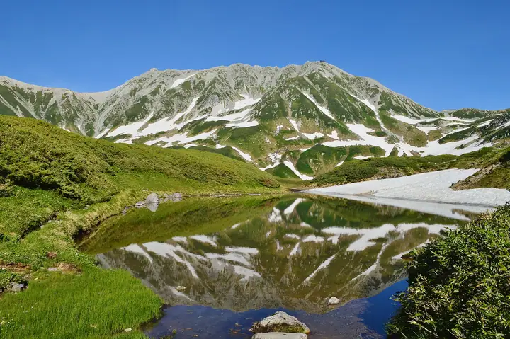
Mount Oyama is a 3003-meter peak at the southern end of Tateyama’s main summits in Chubu Sangaku National Park, Tateyama Town, Toyama Prefecture. Together with Onanjiyama, it is a center of Tateyama worship. Oyama-jinja Mine-honsha stands at the summit, with worship services during the July 1–September 30 opening season. About two hours from Murodo Terminal via Ichinokoshi, it is widely visited using the Tateyama Kurobe Alpine Route.
Mount Oyama at a glance
- Weather: The most settled day in the next 7 days is Wed, November 4: clear, gusts up to 7 m/s. Fri, Nov 6, Sat, Nov 7: strong wind (gusts up to 21 m/s).
- Route: The shortest is Mount Tate Loop via Oyama, Onanjiyama, and Fuji-no-Oritate: about 5 h 28 min, 8.4 km, about 840 m of climbing.
Mount Oyama weather (hourly, 14 days)
Sunrise today 06:14, sunset 16:52
| Tue, 11/3 | Wed, 11/4 | Thu, 11/5 | Fri, 11/6 | Sat, 11/7 | Sun, 11/8 | Mon, 11/9 | Tue, 11/10 | Wed, 11/11 | Thu, 11/12 | Fri, 11/13 | Sat, 11/14 | Sun, 11/15 | Mon, 11/16 | Tue, 11/17 | |||||||||||||||||||||||||||||||||||||||||||||||||||||||||||||||||||||
|---|---|---|---|---|---|---|---|---|---|---|---|---|---|---|---|---|---|---|---|---|---|---|---|---|---|---|---|---|---|---|---|---|---|---|---|---|---|---|---|---|---|---|---|---|---|---|---|---|---|---|---|---|---|---|---|---|---|---|---|---|---|---|---|---|---|---|---|---|---|---|---|---|---|---|---|---|---|---|---|---|---|---|---|
| Japan time | 21 | 23 | 1 | 3 | 5 | 7 | 9 | 11 | 13 | 15 | 17 | 19 | 21 | 0 | 3 | 6 | 9 | 12 | 15 | 18 | 21 | 0 | 3 | 6 | 9 | 12 | 15 | 18 | 21 | 0 | 3 | 6 | 9 | 12 | 15 | 18 | 21 | 0 | 3 | 6 | 9 | 12 | 15 | 18 | 21 | 0 | 3 | 6 | 9 | 15 | 21 | 3 | 9 | 15 | 21 | 3 | 9 | 15 | 21 | 3 | 9 | 15 | 21 | 3 | 9 | 15 | 21 | 3 | 9 | 15 | 21 | 3 | 9 | 15 | 21 | 3 | 9 | 15 | 21 | 3 | 9 | 15 | |
  | | | |  |   |  | | | |   |   | |   | | |   |   | | | | | | | | | |   | |   | | |   | | | | | | | | | |   |   | | | | | | | |   | | | | | | | |  | | | | | |   | | | | | | | | | | | |   | | | | | ||
| Temperature | °C | -13° | -11° | -11° | -10° | -10° | -8° | -2° | 1° | 2° | 1° | -3° | -3° | -3° | -3° | -3° | -1° | 2° | 4° | 3° | 0° | -1° | -1° | -1° | -2° | -2° | -3° | -3° | -6° | -7° | -9° | -11° | -12° | -12° | -11° | -12° | -14° | -15° | -17° | -18° | -16° | -7° | -5° | -6° | -9° | -9° | -9° | -9° | -8° | -6° | -7° | -16° | -16° | -5° | -5° | -8° | -14° | -11° | -10° | -13° | -16° | -7° | -6° | -16° | -9° | -9° | -8° | -14° | -15° | -4° | -2° | -12° | -12° | -2° | -2° | -3° | -3° | -3° | -6° | -11° | -14° | -6° | -4° |
| Precipitation | mm | 3.6 | 9 | 5.0 | 0.1 | 1.0 | 1.1 | 1.4 | 4.1 | 2.1 | 2.3 | 0.9 | 2.3 | 1.8 | 4.6 | 3.6 | 3.7 | 3.4 | 1.9 | 1.0 | 0.5 | 0.4 | 1.6 | 2.0 | 0.2 | 0.6 | 4.9 | 11 | 8 | 2.7 | 2.4 | 5 | 0.3 | 0.7 | 8 | 8 | 6 | 9 | 4.2 | ||||||||||||||||||||||||||||||||||||||||||||
| New snow | cm | – | – | 0.2 | 0.9 | 4.3 | 3.5 | 3.6 | 3.3 | 1.9 | 1.0 | 0.5 | <.1 | <.1 | <.1 | 0.4 | 1.6 | 1.9 | 0.2 | 0.6 | <.1 | 4.8 | 10 | 8.2 | 2.7 | <.1 | 2.3 | 4.7 | 0.3 | 2.1 | 3.3 | ||||||||||||||||||||||||||||||||||||||||||||||||||||
| Snow depth | cm | 0 | 0 | 0 | 0 | 0 | 0 | 0 | 0 | 0 | 0 | 0 | 0 | 0 | 0 | 0 | 0 | 0 | 0 | 0 | 0 | 0 | 0 | 0 | 0 | 0 | 0 | 0 | 0 | <1 | 4 | 6 | 9 | 12 | 13 | 14 | 14 | 13 | 13 | 13 | 12 | 12 | 12 | 11 | 11 | 11 | 11 | 12 | 14 | 14 | 12 | 12 | 12 | 12 | 11 | 14 | 23 | 29 | 30 | 29 | 28 | 28 | 27 | 26 | 28 | 31 | 30 | 30 | 29 | 29 | 28 | 28 | 28 | 27 | 25 | 24 | 22 | 20 | 19 | 21 | 20 | 20 | 20 |
| Wind | m/s | 1 | 1 | 1 | 0 | 0 | 1 | 1 | 0 | 1 | 1 | 1 | 1 | 1 | 0 | 0 | 2 | 2 | 2 | 1 | 0 | 1 | 2 | 1 | 2 | 3 | 4 | 3 | 4 | 4 | 3 | 4 | 4 | 4 | 5 | 3 | 2 | 2 | 2 | 1 | 1 | 1 | 2 | 0 | 1 | 1 | 1 | 1 | 2 | 2 | 1 | 1 | 1 | 1 | 2 | 3 | 7 | 4 | 2 | 1 | 1 | 1 | 1 | 1 | 2 | 2 | 1 | 1 | 1 | 1 | 0 | 1 | 1 | 1 | 1 | 2 | 2 | 1 | 3 | 1 | 0 | 0 | 0 |
| Wind gusts | m/s | 8 | 8 | 7 | 6 | 6 | 5 | 6 | 6 | 7 | 7 | 6 | 7 | 8 | 8 | 6 | 12 | 12 | 10 | 10 | 11 | 8 | 11 | 10 | 11 | 14 | 16 | 19 | 17 | 17 | 16 | 18 | 18 | 18 | 21 | 20 | 16 | 13 | 12 | 12 | 11 | 10 | 9 | 9 | 9 | 9 | 10 | 11 | 11 | 11 | 11 | 8 | 7 | 7 | 12 | 14 | 28 | 30 | 19 | 11 | 6 | 7 | 9 | 7 | 11 | 11 | 11 | 9 | 8 | 6 | 6 | 6 | 8 | 9 | 13 | 15 | 18 | 14 | 15 | 14 | 7 | 4 | 5 |
| Wind dir. | ↓ | ↓ | ↓ | ↓ | ↓ | ↓ | ↓ | ↓ | ↓ | ↓ | ↓ | ↓ | ↓ | ↓ | ↓ | ↓ | ↓ | ↓ | ↓ | ↓ | ↓ | ↓ | ↓ | ↓ | ↓ | ↓ | ↓ | ↓ | ↓ | ↓ | ↓ | ↓ | ↓ | ↓ | ↓ | ↓ | ↓ | ↓ | ↓ | ↓ | ↓ | ↓ | ↓ | ↓ | ↓ | ↓ | ↓ | ↓ | ↓ | ↓ | ↓ | ↓ | ↓ | ↓ | ↓ | ↓ | ↓ | ↓ | ↓ | ↓ | ↓ | ↓ | ↓ | ↓ | ↓ | ↓ | ↓ | ↓ | ↓ | ↓ | ↓ | ↓ | ↓ | ↓ | ↓ | ↓ | ↓ | ↓ | ↓ | ↓ | ↓ | ↓ | |
Mount Oyama live cameras
Mount Oyama hiking routes
- Mount Tate Loop via Oyama, Onanjiyama, and Fuji-no-Oritate 8.4 km · Ascent 836 m Murodō (Bus station)
- Mount Oyama–Bessan Circuit from Murodo 10.7 km · Ascent 1,057 m Murodō (Bus station)
- Murodo–Tateyama Traverse and Mount Tsurugi Betsusan Ridge Circuit 18.5 km · Ascent 2,129 m Murodō (Bus station)
Hiking times are estimates calculated from the terrain.
Huts, campsites and lodging near Mount Oyama
Mountain huts
- 大汝休憩所 2026: open July 4–October 4
- Ichinokoshi Sanso 2026: open April 25–October 17 · reservation required · sleeps 130
- Tateyama Murodo Sanso 2026: open April 15–November 23 · reservation required · sleeps 100
- Kuranosuke Sanso 2026: open July 16–September 30 · reservation required · sleeps 40
- Raicho Onsen Raicho-so 2026: open April 15–November 24 · reservation required
Campsites
- Raicho-zawa Camping Site
- Tsurugisawa Campsite
- Kurojon
- 五色ヶ原山荘テント場
Lodging
- Tatehama Kogen Hotel
Lists that include Mount Oyama
Mount Oyama facts
- Elevation
- 3,003 m
- Location
- Tateyama, Toyama
36.573190, 137.617884 - National Park
- 中部山岳国立公園
- Season Opens
- July 1
- Season Closes
- September 30
- Website
- www.town.tateyama.toyama.jp
- Trail Map
- www.town.tateyama.toyama.jp
- Access Information
- www.town.tateyama.toyama.jp
- Wikipedia
- ja.wikipedia.org