
Mount Okukane
奥鐘山
Kurobe, Toyama · Elevation 1,543 m
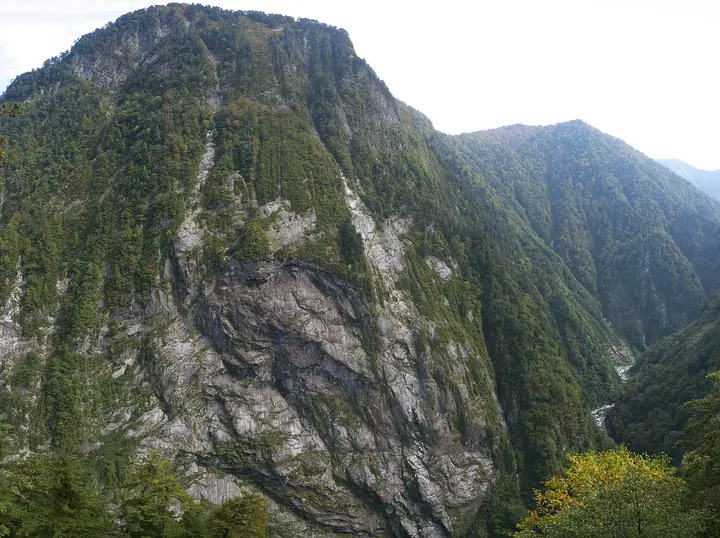
Mount Okukane is a 1,543 m peak in the Ushiro-Tateyama Range of the Hida (Northern Alps) Mountains in Kurobe City, Toyama Prefecture. Its 1 km-wide, 800 m-high western wall above the Kurobe Gorge is one of Japan's premier climbing walls — nicknamed the 'Monster of Kurobe' and counted among the gorge's three great rock faces. The mountain is part of the nationally designated Special Place of Scenic Beauty and Special Natural Monument 'Kurobe Gorge with Sarutobi and Mt Okukane' and appears on the Yama-1000, Shin-Ecchu Hyakuzan, Ecchu Hyakuzan, and Hokuriku Hyakuzan lists.
Mount Okukane at a glance
- Weather: The most settled day in the next 7 days is Wed, November 4: clear, gusts up to 6 m/s. Fri, Nov 6, Sat, Nov 7: strong wind (gusts up to 20 m/s).
Mount Okukane weather (hourly, 14 days)
Sunrise today 06:14, sunset 16:52
| Tue, 11/3 | Wed, 11/4 | Thu, 11/5 | Fri, 11/6 | Sat, 11/7 | Sun, 11/8 | Mon, 11/9 | Tue, 11/10 | Wed, 11/11 | Thu, 11/12 | Fri, 11/13 | Sat, 11/14 | Sun, 11/15 | Mon, 11/16 | Tue, 11/17 | |||||||||||||||||||||||||||||||||||||||||||||||||||||||||||||||||||||||
|---|---|---|---|---|---|---|---|---|---|---|---|---|---|---|---|---|---|---|---|---|---|---|---|---|---|---|---|---|---|---|---|---|---|---|---|---|---|---|---|---|---|---|---|---|---|---|---|---|---|---|---|---|---|---|---|---|---|---|---|---|---|---|---|---|---|---|---|---|---|---|---|---|---|---|---|---|---|---|---|---|---|---|---|---|---|
| Japan time | 21 | 23 | 1 | 3 | 5 | 7 | 9 | 11 | 13 | 15 | 17 | 19 | 21 | 0 | 3 | 6 | 9 | 12 | 15 | 18 | 21 | 0 | 3 | 6 | 9 | 12 | 15 | 18 | 21 | 0 | 3 | 6 | 9 | 12 | 15 | 18 | 21 | 0 | 3 | 6 | 9 | 12 | 15 | 18 | 21 | 0 | 3 | 6 | 9 | 12 | 15 | 21 | 3 | 9 | 15 | 21 | 3 | 9 | 15 | 21 | 3 | 9 | 15 | 21 | 3 | 9 | 15 | 21 | 3 | 9 | 15 | 21 | 3 | 9 | 15 | 21 | 3 | 9 | 15 | 21 | 3 | 9 | 15 | 21 | |
  |   | | |  |   |  | | | | | |   |   | |   |   | |   | | | | | | | | | |   |   | | |   | | | | | | | | | |   | |   | | | | | | | |   | | | | | | | | | | | | | |   | |  | | | | | |   | | | |   | | | | | | ||
| Temperature | °C | -4° | -4° | -4° | -2° | -2° | -1° | 6° | 9° | 10° | 9° | 5° | 5° | 5° | 5° | 5° | 6° | 10° | 12° | 11° | 8° | 8° | 7° | 7° | 5° | 5° | 5° | 4° | 2° | 1° | -1° | -2° | -3° | -3° | -3° | -3° | -5° | -5° | -7° | -7° | -7° | -1° | 2° | 1° | -3° | -2° | -1° | 1° | 1° | 4° | 3° | 2° | -5° | -8° | 3° | 4° | 0° | -5° | -3° | -3° | -4° | -8° | 0° | 1° | -7° | -1° | -1° | 0° | -7° | -8° | 3° | 5° | -3° | -2° | 7° | 6° | 6° | 6° | 5° | 2° | -3° | -6° | 1° | 3° | -4° |
| Precipitation | mm | 4.0 | 9 | 5 | 0.8 | 0.2 | 3.1 | 0.3 | 12 | 7 | 2.1 | 3.2 | 2.9 | 5 | 3.6 | 3.6 | 4.5 | 3.0 | 3.2 | 2.9 | 2.2 | 0.7 | 0.9 | 0.4 | 0.2 | 0.1 | 0.2 | 8 | 14 | 10 | 4.1 | 0.3 | 3.3 | 8 | 0.5 | 0.7 | 7 | 7 | 12 | 14 | 4.3 | ||||||||||||||||||||||||||||||||||||||||||||
| New snow | cm | 1.9 | 2.9 | 4.1 | 2.7 | 3.1 | 2.9 | 2.2 | 0.7 | 0.9 | 0.4 | 0.2 | 0.1 | <.1 | <.1 | 0.4 | 7.6 | 13 | 10 | 4.1 | 0.3 | <.1 | 3.2 | 6.7 | 0.5 | 0.7 | 2.0 | ||||||||||||||||||||||||||||||||||||||||||||||||||||||||||
| Snow depth | cm | 0 | 0 | 0 | 0 | 0 | 0 | 0 | 0 | 0 | 0 | 0 | 0 | 0 | 0 | 0 | 0 | 0 | 0 | 0 | 0 | 0 | 0 | 0 | 0 | 0 | 0 | 0 | 0 | <1 | 4 | 7 | 10 | 12 | 13 | 15 | 15 | 16 | 16 | 15 | 15 | 15 | 14 | 14 | 13 | 13 | 13 | 14 | 16 | 15 | 15 | 14 | 13 | 13 | 13 | 11 | 16 | 26 | 33 | 34 | 33 | 32 | 32 | 31 | 30 | 32 | 36 | 35 | 34 | 34 | 33 | 32 | 32 | 32 | 31 | 29 | 28 | 26 | 24 | 21 | 22 | 22 | 21 | 20 | 20 |
| Wind | m/s | 1 | 0 | 0 | 0 | 0 | 1 | 1 | 0 | 0 | 1 | 1 | 1 | 1 | 1 | 1 | 0 | 0 | 1 | 1 | 0 | 1 | 1 | 2 | 3 | 3 | 3 | 4 | 4 | 3 | 3 | 3 | 3 | 4 | 4 | 4 | 3 | 2 | 1 | 1 | 1 | 1 | 1 | 1 | 1 | 1 | 0 | 0 | 0 | 1 | 2 | 1 | 1 | 0 | 1 | 3 | 3 | 7 | 5 | 2 | 0 | 1 | 1 | 2 | 1 | 2 | 3 | 1 | 0 | 0 | 0 | 0 | 0 | 1 | 0 | 1 | 1 | 2 | 2 | 3 | 1 | 1 | 1 | 1 | 0 |
| Wind gusts | m/s | 7 | 7 | 5 | 5 | 5 | 5 | 6 | 6 | 5 | 5 | 6 | 7 | 7 | 7 | 7 | 10 | 10 | 8 | 9 | 8 | 11 | 13 | 14 | 14 | 14 | 17 | 18 | 19 | 18 | 17 | 15 | 17 | 18 | 19 | 20 | 19 | 14 | 12 | 10 | 10 | 8 | 8 | 8 | 7 | 8 | 9 | 10 | 11 | 10 | 12 | 11 | 8 | 5 | 5 | 15 | 16 | 30 | 30 | 21 | 12 | 5 | 7 | 10 | 9 | 10 | 12 | 12 | 9 | 7 | 5 | 7 | 5 | 6 | 7 | 14 | 18 | 17 | 14 | 16 | 16 | 7 | 5 | 6 | 5 |
| Wind dir. | ↓ | ↓ | ↓ | ↓ | ↓ | ↓ | ↓ | ↓ | ↓ | ↓ | ↓ | ↓ | ↓ | ↓ | ↓ | ↓ | ↓ | ↓ | ↓ | ↓ | ↓ | ↓ | ↓ | ↓ | ↓ | ↓ | ↓ | ↓ | ↓ | ↓ | ↓ | ↓ | ↓ | ↓ | ↓ | ↓ | ↓ | ↓ | ↓ | ↓ | ↓ | ↓ | ↓ | ↓ | ↓ | ↓ | ↓ | ↓ | ↓ | ↓ | ↓ | ↓ | ↓ | ↓ | ↓ | ↓ | ↓ | ↓ | ↓ | ↓ | ↓ | ↓ | ↓ | ↓ | ↓ | ↓ | ↓ | ↓ | ↓ | ↓ | ↓ | ↓ | ↓ | ↓ | ↓ | ↓ | ↓ | ↓ | ↓ | ↓ | ↓ | ↓ | ↓ | ↓ | |
Huts, campsites and lodging near Mount Okukane
Mountain huts
- 祖母谷温泉 temporarily closed
- 避難小屋
- Gakiyama Hinangoya temporarily closed
- Azohara-onsen-goya reservation required · sleeps 20
- 仙人温泉小屋 temporarily closed
Campsites
- 祖母谷温泉キャンプ場
- 阿曽原温泉
Lodging
- Meiken Onsen
- 欅平温泉 猿飛山荘
Lists that include Mount Okukane
Mount Okukane facts
- Elevation
- 1,543 m
- Location
- Kurobe, Toyama
36.687702, 137.673079 - National Park
- 中部山岳国立公園
- Website
- www.info-toyama.com
- Wikipedia
- ja.wikipedia.org