
Mount Minami-Koma
南駒ヶ岳
Okuwa, Nagano · Elevation 2,841 m
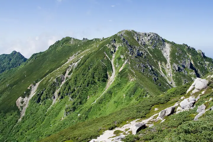
Mount Minami-Koma is a 2,841 m peak straddling Ōkuwa Village in Kiso District and Iijima Town in Kamiina District, Nagano Prefecture, sitting on the main ridge of the Kiso (Central) Alps between Utsugi-dake to the north and Kosumo-yama to the south. Within Central Alps Quasi-National Park, it is listed in the Nihon Nihyaku Meizan, the Nihon Hyakkōzan, and the Shinshū Hyakumeizan. The summit is a tumble of granite boulders crowned by a small shrine, with unobstructed 360° views across the Ina Valley to the Southern Alps and Mount Ontake. Just east of the top, the Suribachikubo cirque cradles a small emergency shelter, and a snow pattern called the "Five Bonze Monks" forms above it each spring — long used by farmers in the Ina Valley as a calendar marker. The standard ascents traverse the ridge from Kosumo via the Inagawa-Dam approach in Ōkuwa, or climb the Kesazawa drainage from Iijima to the Suribachikubo cirque.
Mount Minami-Koma at a glance
- Weather: The most settled day in the next 7 days is Sun, November 8: clear, gusts up to 8 m/s.
Mount Minami-Koma weather (hourly, 14 days)
Sunrise today 06:12, sunset 16:53
| Tue, 11/3 | Wed, 11/4 | Thu, 11/5 | Fri, 11/6 | Sat, 11/7 | Sun, 11/8 | Mon, 11/9 | Tue, 11/10 | Wed, 11/11 | Thu, 11/12 | Fri, 11/13 | Sat, 11/14 | Sun, 11/15 | Mon, 11/16 | Tue, 11/17 | |||||||||||||||||||||||||||||||||||||||||||||||||||||||||||||||||||||||
|---|---|---|---|---|---|---|---|---|---|---|---|---|---|---|---|---|---|---|---|---|---|---|---|---|---|---|---|---|---|---|---|---|---|---|---|---|---|---|---|---|---|---|---|---|---|---|---|---|---|---|---|---|---|---|---|---|---|---|---|---|---|---|---|---|---|---|---|---|---|---|---|---|---|---|---|---|---|---|---|---|---|---|---|---|---|
| Japan time | 21 | 23 | 1 | 3 | 5 | 7 | 9 | 11 | 13 | 15 | 17 | 19 | 21 | 0 | 3 | 6 | 9 | 12 | 15 | 18 | 21 | 0 | 3 | 6 | 9 | 12 | 15 | 18 | 21 | 0 | 3 | 6 | 9 | 12 | 15 | 18 | 21 | 0 | 3 | 6 | 9 | 12 | 15 | 18 | 21 | 0 | 3 | 6 | 9 | 12 | 15 | 21 | 3 | 9 | 15 | 21 | 3 | 9 | 15 | 21 | 3 | 9 | 15 | 21 | 3 | 9 | 15 | 21 | 3 | 9 | 15 | 21 | 3 | 9 | 15 | 21 | 3 | 9 | 15 | 21 | 3 | 9 | 15 | 21 | |
  | | | | |   | | |   | |   | | |   | | |   |   |   | | |   | | | | | | | |   | | | | |  |  | | | | | | | | | | | | | | | | | | | | |   |   | |   |  | | | | | | | | | | | | | | | | | |   | | | | | | ||
| Temperature | °C | -3° | -3° | -3° | -3° | -3° | -3° | 2° | 6° | 8° | 6° | 3° | 2° | 1° | 0° | 0° | 0° | 4° | 8° | 8° | 4° | 3° | 1° | 1° | 2° | 5° | 8° | 6° | 0° | -2° | -4° | -3° | -6° | -1° | 0° | -2° | -7° | -9° | -10° | -10° | -10° | -1° | 4° | 3° | -2° | -4° | -2° | -2° | -1° | 0° | 5° | 4° | -4° | -5° | 1° | 1° | -3° | -6° | -5° | 0° | -8° | -9° | -1° | 1° | -6° | -7° | -1° | 2° | -7° | -9° | -1° | 3° | -4° | -3° | 2° | 3° | 1° | 1° | 4° | 5° | -5° | -5° | -1° | 1° | -2° |
| Precipitation | mm | 4.9 | 8 | 2.9 | 0.8 | 0.1 | 0.5 | 4.6 | 2.5 | 0.5 | 0.5 | 0.7 | 0.6 | 0.6 | 0.2 | 0.2 | 19 | 14 | 0.8 | 1.3 | 0.4 | ||||||||||||||||||||||||||||||||||||||||||||||||||||||||||||||||
| New snow | cm | <.1 | <.1 | ||||||||||||||||||||||||||||||||||||||||||||||||||||||||||||||||||||||||||||||||||
| Snow depth | cm | 0 | 0 | 0 | 0 | 0 | 0 | 0 | 0 | 0 | 0 | 0 | 0 | 0 | 0 | 0 | 0 | 0 | 0 | 0 | 0 | 0 | 0 | 0 | 0 | 0 | 0 | 0 | 0 | 0 | 0 | 0 | 0 | 0 | 0 | 0 | 0 | 0 | 0 | 0 | 0 | 0 | 0 | 0 | 0 | 0 | 0 | 0 | 0 | 0 | 0 | 0 | 0 | 0 | 0 | 0 | 0 | 0 | 0 | 0 | 0 | 0 | 0 | 0 | 0 | 0 | 0 | 0 | 0 | 0 | 0 | 0 | 0 | 0 | 0 | 0 | 0 | 0 | 0 | 0 | 0 | 0 | 0 | 0 | 0 |
| Wind | m/s | 0 | 0 | 0 | 0 | 1 | 1 | 1 | 1 | 1 | 1 | 0 | 1 | 1 | 2 | 1 | 1 | 0 | 1 | 1 | 1 | 1 | 2 | 2 | 1 | 1 | 1 | 2 | 1 | 1 | 2 | 2 | 2 | 1 | 2 | 2 | 2 | 2 | 2 | 1 | 1 | 1 | 1 | 1 | 0 | 0 | 1 | 1 | 1 | 1 | 1 | 2 | 0 | 0 | 2 | 2 | 1 | 1 | 3 | 2 | 1 | 0 | 2 | 1 | 1 | 1 | 2 | 2 | 1 | 1 | 1 | 1 | 1 | 1 | 2 | 2 | 1 | 1 | 1 | 2 | 1 | 1 | 0 | 2 | 1 |
| Wind gusts | m/s | 4 | 5 | 5 | 5 | 5 | 6 | 6 | 6 | 8 | 8 | 7 | 5 | 6 | 8 | 12 | 9 | 7 | 8 | 8 | 8 | 11 | 12 | 15 | 13 | 8 | 9 | 10 | 9 | 9 | 9 | 9 | 9 | 10 | 11 | 12 | 11 | 10 | 10 | 9 | 9 | 7 | 7 | 8 | 6 | 8 | 10 | 10 | 10 | 10 | 10 | 9 | 5 | 6 | 10 | 15 | 11 | 12 | 16 | 16 | 10 | 8 | 10 | 12 | 7 | 5 | 11 | 10 | 9 | 7 | 5 | 8 | 6 | 8 | 12 | 14 | 15 | 15 | 10 | 12 | 11 | 8 | 6 | 11 | 9 |
| Wind dir. | ↓ | ↓ | ↓ | ↓ | ↓ | ↓ | ↓ | ↓ | ↓ | ↓ | ↓ | ↓ | ↓ | ↓ | ↓ | ↓ | ↓ | ↓ | ↓ | ↓ | ↓ | ↓ | ↓ | ↓ | ↓ | ↓ | ↓ | ↓ | ↓ | ↓ | ↓ | ↓ | ↓ | ↓ | ↓ | ↓ | ↓ | ↓ | ↓ | ↓ | ↓ | ↓ | ↓ | ↓ | ↓ | ↓ | ↓ | ↓ | ↓ | ↓ | ↓ | ↓ | ↓ | ↓ | ↓ | ↓ | ↓ | ↓ | ↓ | ↓ | ↓ | ↓ | ↓ | ↓ | ↓ | ↓ | ↓ | ↓ | ↓ | ↓ | ↓ | ↓ | ↓ | ↓ | ↓ | ↓ | ↓ | ↓ | ↓ | ↓ | ↓ | ↓ | ↓ | ↓ | |
Huts, campsites and lodging near Mount Minami-Koma
Mountain huts
Lists that include Mount Minami-Koma
Japan 200 Famous Mountains · Japan's 300 Famous Mountains · Japan's 100 Highest Mountains · Shinshu 100 Famous Mountains · Shinshu Mountain Cards · Elevations of 1003 Mountains of Japan · 1000 Mountains of Japan
Mount Minami-Koma facts
- Elevation
- 2,841 m
- Location
- Okuwa, Nagano
35.701390, 137.810746 - National Park
- 中央アルプス国定公園
- Website
- www.vill.okuwa.lg.jp
- Trail Map
- inashi-kankoukyoukai.jp (PDF)
- Access Information
- www.vill.okuwa.lg.jp
- Wikipedia
- ja.wikipedia.org