
Mount Kusatsu-Shirane
草津白根山
Kusatsu, Gunma · Elevation 2,160 m
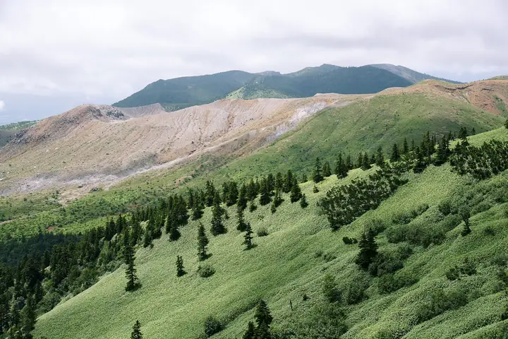
An active volcano at 2160 m in Kusatsu, Gunma, within Joshinetsu-Kogen National Park. It is a pyroclastic cone of Kusatsu-Shirane, with the crater lakes Yugama, Mizugama and Karegama near its summit; milky blue Yugama is its signature sight. The volcano is continuously monitored, and Honshirane erupted in 2018. Entry within 500 m of Yugama remains restricted under Article 63 of the Disaster Countermeasures Basic Act. Parts of the western trail and Lake Yumiike area outside that zone are scheduled for trial opening at limited hours from October 13 to November 8, 2026.
Mount Kusatsu-Shirane at a glance
- Weather: The most settled day in the next 7 days is Wed, November 4: clear, gusts up to 8 m/s. Sat, Nov 7: strong wind (gusts up to 16 m/s).
Mount Kusatsu-Shirane weather (hourly, 14 days)
Sunrise today 06:11, sunset 16:48
| Tue, 11/3 | Wed, 11/4 | Thu, 11/5 | Fri, 11/6 | Sat, 11/7 | Sun, 11/8 | Mon, 11/9 | Tue, 11/10 | Wed, 11/11 | Thu, 11/12 | Fri, 11/13 | Sat, 11/14 | Sun, 11/15 | Mon, 11/16 | Tue, 11/17 | |||||||||||||||||||||||||||||||||||||||||||||||||||||||||||||||||||||||
|---|---|---|---|---|---|---|---|---|---|---|---|---|---|---|---|---|---|---|---|---|---|---|---|---|---|---|---|---|---|---|---|---|---|---|---|---|---|---|---|---|---|---|---|---|---|---|---|---|---|---|---|---|---|---|---|---|---|---|---|---|---|---|---|---|---|---|---|---|---|---|---|---|---|---|---|---|---|---|---|---|---|---|---|---|---|
| Japan time | 15 | 17 | 19 | 21 | 23 | 1 | 3 | 5 | 7 | 9 | 11 | 13 | 15 | 18 | 21 | 0 | 3 | 6 | 9 | 12 | 15 | 18 | 21 | 0 | 3 | 6 | 9 | 12 | 15 | 18 | 21 | 0 | 3 | 6 | 9 | 12 | 15 | 18 | 21 | 0 | 3 | 6 | 9 | 12 | 15 | 18 | 21 | 0 | 3 | 6 | 9 | 15 | 21 | 3 | 9 | 15 | 21 | 3 | 9 | 15 | 21 | 3 | 9 | 15 | 21 | 3 | 9 | 15 | 21 | 3 | 9 | 15 | 21 | 3 | 9 | 15 | 21 | 3 | 9 | 15 | 21 | 3 | 9 | 15 | |
  |   | |  | | | | |  |   | | | |   |   | | | |   |   | | | | |   |   | | | | | | | |   |   | | | | | | | | | | | | | |   | |   | | | | | | |   |   | | | | | | | | | | | | | |  | | | | |   | | | | | | | ||
| Temperature | °C | 2° | -1° | -4° | -5° | -4° | -4° | -3° | -3° | -2° | 4° | 6° | 7° | 5° | 1° | 0° | 1° | 2° | 3° | 6° | 10° | 9° | 5° | 6° | 5° | 4° | 3° | 8° | 10° | 9° | 3° | 1° | 0° | -1° | -3° | -1° | 1° | -1° | -4° | -5° | -5° | -5° | -5° | -2° | 1° | -1° | -4° | -4° | -3° | -2° | -2° | 1° | 2° | -2° | -2° | 0° | 0° | -2° | -4° | -5° | -4° | -4° | -5° | -1° | 1° | -6° | -3° | -2° | -3° | -5° | -7° | 1° | 4° | -4° | -2° | 3° | 6° | 1° | 2° | 6° | 2° | -3° | -5° | 0° | 2° |
| Precipitation | mm | 0.4 | 0.9 | 10 | 5 | 2.0 | 1.0 | 0.1 | 0.1 | 0.2 | 0.3 | 0.3 | 0.1 | 0.7 | 0.1 | 0.2 | 0.2 | 1.9 | 3.6 | 4.3 | 1.2 | 3.1 | 1.1 | 6 | 6 | 1.2 | 2.2 | ||||||||||||||||||||||||||||||||||||||||||||||||||||||||||
| New snow | cm | <.1 | <.1 | 0.1 | <.1 | 0.3 | 0.2 | 1.4 | 3.6 | 4.2 | 1.0 | 3.0 | 1.1 | 0.3 | |||||||||||||||||||||||||||||||||||||||||||||||||||||||||||||||||||||||
| Snow depth | cm | 0 | 0 | 0 | 0 | 0 | 0 | 0 | 0 | 0 | 0 | 0 | 0 | 0 | 0 | 0 | 0 | 0 | 0 | 0 | 0 | 0 | 0 | 0 | 0 | 0 | 0 | 0 | 0 | 0 | 0 | 0 | 0 | 0 | 0 | 0 | 0 | 0 | 0 | 0 | 0 | 0 | 0 | 0 | 0 | 0 | 0 | 0 | 0 | 0 | 0 | 0 | 0 | 0 | 0 | 0 | 0 | 0 | <1 | 3 | 6 | 6 | 6 | 6 | 4 | 4 | 4 | 6 | 6 | 5 | 5 | 5 | 4 | 4 | 4 | 3 | 2 | 1 | <1 | <1 | 0 | 0 | 0 | 0 | 0 |
| Wind | m/s | 2 | 2 | 1 | 1 | 1 | 0 | 1 | 1 | 0 | 1 | 2 | 2 | 2 | 2 | 2 | 2 | 1 | 1 | 0 | 0 | 0 | 1 | 0 | 1 | 1 | 1 | 2 | 4 | 4 | 2 | 2 | 3 | 3 | 3 | 3 | 5 | 4 | 3 | 2 | 2 | 3 | 3 | 3 | 3 | 3 | 1 | 1 | 1 | 1 | 1 | 1 | 1 | 1 | 0 | 2 | 1 | 0 | 5 | 6 | 6 | 2 | 2 | 1 | 0 | 0 | 2 | 2 | 4 | 2 | 2 | 0 | 0 | 0 | 1 | 0 | 1 | 0 | 2 | 2 | 5 | 4 | 3 | 1 | 1 |
| Wind gusts | m/s | 9 | 8 | 6 | 5 | 5 | 4 | 4 | 4 | 4 | 4 | 6 | 7 | 8 | 7 | 8 | 8 | 7 | 7 | 6 | 6 | 6 | 4 | 4 | 5 | 6 | 7 | 8 | 12 | 14 | 12 | 10 | 11 | 12 | 11 | 13 | 16 | 16 | 13 | 11 | 10 | 11 | 12 | 11 | 10 | 11 | 9 | 6 | 6 | 6 | 7 | 7 | 7 | 5 | 3 | 6 | 9 | 7 | 18 | 27 | 25 | 18 | 9 | 7 | 6 | 5 | 7 | 10 | 14 | 13 | 10 | 7 | 4 | 4 | 4 | 5 | 8 | 7 | 11 | 10 | 17 | 18 | 13 | 8 | 6 |
| Wind dir. | ↓ | ↓ | ↓ | ↓ | ↓ | ↓ | ↓ | ↓ | ↓ | ↓ | ↓ | ↓ | ↓ | ↓ | ↓ | ↓ | ↓ | ↓ | ↓ | ↓ | ↓ | ↓ | ↓ | ↓ | ↓ | ↓ | ↓ | ↓ | ↓ | ↓ | ↓ | ↓ | ↓ | ↓ | ↓ | ↓ | ↓ | ↓ | ↓ | ↓ | ↓ | ↓ | ↓ | ↓ | ↓ | ↓ | ↓ | ↓ | ↓ | ↓ | ↓ | ↓ | ↓ | ↓ | ↓ | ↓ | ↓ | ↓ | ↓ | ↓ | ↓ | ↓ | ↓ | ↓ | ↓ | ↓ | ↓ | ↓ | ↓ | ↓ | ↓ | ↓ | ↓ | ↓ | ↓ | ↓ | ↓ | ↓ | ↓ | ↓ | ↓ | ↓ | ↓ | ||
Mount Kusatsu-Shirane live cameras
Huts, campsites and lodging near Mount Kusatsu-Shirane
Mountain huts
Campsites
- 芳ヶ平野営場
Lodging
- 湯の花旅館
- 万座ホテルジュラク
- 万座温泉 日進舘
- 万座亭
- 万座プリンスホテル
Lists that include Mount Kusatsu-Shirane
Elevations of 1003 Mountains of Japan · 1000 Mountains of Japan
Mount Kusatsu-Shirane facts
- Also known as
- 地蔵岳 · Mount Shirane
- Elevation
- 2,160 m
- Location
- Kusatsu, Gunma
36.643949, 138.527738 - National Park
- 上信越高原国立公園
- Volcano
- Active volcano (草津白根山)
- Website
- www.town.kusatsu.gunma.jp
- Wikipedia
- ja.wikipedia.org