
Mount Eboshi
烏帽子岳
Toyama, Toyama · Elevation 2,628 m
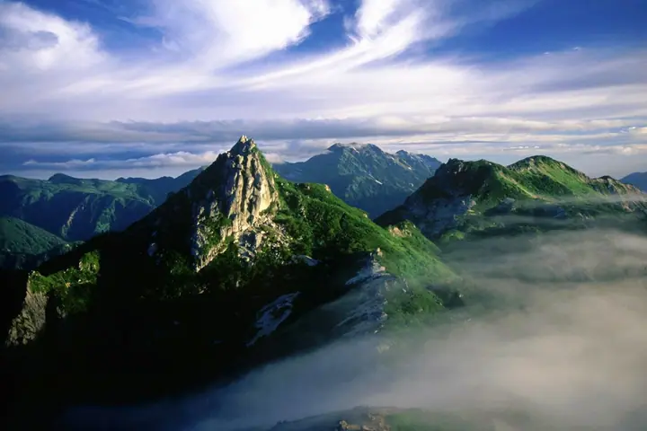
Mount Eboshi is a 2,628 m peak straddling Toyama City in Toyama Prefecture and Ōmachi City in Nagano Prefecture, rising on the main ridge of the Hida (Northern Japanese) Alps within Chūbu Sangaku National Park. The sharp eboshi (court-cap) rock tower at the summit gives the mountain its name, and it is the starting point of the renowned Ura-Ginza traverse. Listed in the Nihon Nihyaku Meizan, the Shinshū Hyakumeizan, and the Toyama no Hyakuzan, the high ridge is fringed with white granitic gravel, dwarf pine and shirabiso fir, the Yotsugōra tarns, and notable colonies of Komakusa. The standard ascent climbs the Bunadate Ridge from the Nanakura trailhead beyond the Takase Dam — one of the "Big Three" steepest climbs in Japan with 1,250 m of relief — reaching Eboshi-goya hut on the ridge, from where the summit is about 45 minutes farther. The hut also serves as the launching point for the long Ura-Ginza traverse to Noguchi-Gorō, Suishō, and Washiba.
Mount Eboshi at a glance
- Weather: The most settled day in the next 7 days is Wed, November 4: clear, gusts up to 10 m/s. Thu, Nov 5, Fri, Nov 6, Sat, Nov 7: strong wind (gusts up to 20 m/s).
Mount Eboshi weather (hourly, 14 days)
Sunrise today 06:14, sunset 16:52
| Tue, 11/3 | Wed, 11/4 | Thu, 11/5 | Fri, 11/6 | Sat, 11/7 | Sun, 11/8 | Mon, 11/9 | Tue, 11/10 | Wed, 11/11 | Thu, 11/12 | Fri, 11/13 | Sat, 11/14 | Sun, 11/15 | Mon, 11/16 | Tue, 11/17 | |||||||||||||||||||||||||||||||||||||||||||||||||||||||||||||||||||||||
|---|---|---|---|---|---|---|---|---|---|---|---|---|---|---|---|---|---|---|---|---|---|---|---|---|---|---|---|---|---|---|---|---|---|---|---|---|---|---|---|---|---|---|---|---|---|---|---|---|---|---|---|---|---|---|---|---|---|---|---|---|---|---|---|---|---|---|---|---|---|---|---|---|---|---|---|---|---|---|---|---|---|---|---|---|---|
| Japan time | 15 | 17 | 19 | 21 | 23 | 1 | 3 | 5 | 7 | 9 | 11 | 13 | 15 | 18 | 21 | 0 | 3 | 6 | 9 | 12 | 15 | 18 | 21 | 0 | 3 | 6 | 9 | 12 | 15 | 18 | 21 | 0 | 3 | 6 | 9 | 12 | 15 | 18 | 21 | 0 | 3 | 6 | 9 | 12 | 15 | 18 | 21 | 0 | 3 | 6 | 9 | 15 | 21 | 3 | 9 | 15 | 21 | 3 | 9 | 15 | 21 | 3 | 9 | 15 | 21 | 3 | 9 | 15 | 21 | 3 | 9 | 15 | 21 | 3 | 9 | 15 | 21 | 3 | 9 | 15 | 21 | 3 | 9 | 15 | |
  |   | |  | | | | | | |  | |   |   |   | | | |   | |   | | | | | | |   | |   | |   | | |   | | | | |   |  | | | | | |   | | | | | | | | | | | | |   | |  | | | | |   |   | | | | | | | | | | | | | | | | | ||
| Temperature | °C | 0° | -5° | -7° | -7° | -7° | -6° | -5° | -5° | -4° | 1° | 4° | 5° | 3° | -1° | 0° | 0° | 0° | 1° | 2° | 4° | 6° | 2° | 2° | 1° | 1° | 1° | 1° | 1° | 0° | -3° | -5° | -7° | -8° | -9° | -9° | -9° | -9° | -12° | -13° | -13° | -13° | -11° | -3° | -1° | -3° | -7° | -6° | -6° | -6° | -6° | -4° | -4° | -13° | -12° | -4° | -4° | -6° | -12° | -9° | -8° | -10° | -12° | -3° | -3° | -11° | -6° | -6° | -5° | -10° | -10° | 0° | 1° | -8° | -7° | 0° | 0° | -1° | -1° | 0° | -3° | -8° | -8° | -2° | -2° |
| Precipitation | mm | 0.1 | 2.0 | 10 | 8 | 6 | 1.2 | 0.4 | 1.3 | 2.2 | 1.0 | 1.0 | 0.3 | 1.0 | 0.5 | 2.3 | 2.4 | 2.5 | 2.3 | 1.2 | 0.3 | 0.1 | 0.2 | 1.4 | 1.8 | 0.2 | 1.0 | 2.5 | 8 | 6 | 1.3 | 1.4 | 2.7 | 0.1 | 1.0 | 11 | 9 | 3.8 | 3.5 | 2.0 | |||||||||||||||||||||||||||||||||||||||||||||
| New snow | cm | 0.2 | 0.3 | 2.2 | 2.4 | 2.5 | 2.3 | 1.2 | 0.3 | <.1 | <.1 | <.1 | 0.2 | 1.4 | 1.6 | 0.2 | 1.0 | <.1 | <.1 | 2.5 | 7.2 | 5.7 | 1.3 | <.1 | 1.4 | 2.2 | 0.1 | <.1 | 1.3 | 1.7 | |||||||||||||||||||||||||||||||||||||||||||||||||||||||
| Snow depth | cm | 0 | 0 | 0 | 0 | 0 | 0 | 0 | 0 | 0 | 0 | 0 | 0 | 0 | 0 | 0 | 0 | 0 | 0 | 0 | 0 | 0 | 0 | 0 | 0 | 0 | 0 | 0 | 0 | 0 | 0 | <1 | 2 | 4 | 6 | 8 | 8 | 8 | 8 | 8 | 8 | 8 | 7 | 7 | 7 | 7 | 7 | 7 | 7 | 8 | 9 | 9 | 9 | 9 | 8 | 8 | 8 | 10 | 16 | 20 | 20 | 19 | 19 | 18 | 17 | 17 | 18 | 19 | 19 | 19 | 18 | 18 | 17 | 17 | 17 | 16 | 15 | 13 | 12 | 10 | 9 | 10 | 10 | 10 | 9 |
| Wind | m/s | 1 | 1 | 1 | 1 | 1 | 1 | 1 | 1 | 1 | 1 | 2 | 2 | 2 | 1 | 2 | 0 | 0 | 1 | 3 | 3 | 2 | 1 | 2 | 2 | 2 | 2 | 3 | 3 | 3 | 3 | 3 | 3 | 3 | 4 | 4 | 4 | 3 | 3 | 2 | 2 | 2 | 1 | 1 | 1 | 0 | 1 | 2 | 2 | 3 | 2 | 2 | 1 | 1 | 1 | 2 | 2 | 2 | 7 | 4 | 2 | 1 | 0 | 1 | 0 | 1 | 2 | 3 | 2 | 1 | 0 | 1 | 1 | 1 | 1 | 2 | 1 | 3 | 3 | 2 | 3 | 1 | 0 | 0 | 1 |
| Wind gusts | m/s | 10 | 8 | 9 | 9 | 9 | 8 | 7 | 7 | 7 | 8 | 9 | 10 | 10 | 10 | 11 | 11 | 8 | 9 | 14 | 18 | 16 | 12 | 11 | 13 | 13 | 13 | 14 | 15 | 19 | 16 | 16 | 16 | 17 | 18 | 19 | 20 | 20 | 17 | 15 | 14 | 14 | 14 | 12 | 9 | 9 | 11 | 12 | 13 | 15 | 15 | 13 | 12 | 7 | 8 | 10 | 14 | 14 | 27 | 30 | 20 | 13 | 7 | 9 | 11 | 8 | 12 | 12 | 12 | 11 | 10 | 7 | 7 | 8 | 9 | 11 | 14 | 18 | 19 | 15 | 15 | 15 | 8 | 5 | 7 |
| Wind dir. | ↓ | ↓ | ↓ | ↓ | ↓ | ↓ | ↓ | ↓ | ↓ | ↓ | ↓ | ↓ | ↓ | ↓ | ↓ | ↓ | ↓ | ↓ | ↓ | ↓ | ↓ | ↓ | ↓ | ↓ | ↓ | ↓ | ↓ | ↓ | ↓ | ↓ | ↓ | ↓ | ↓ | ↓ | ↓ | ↓ | ↓ | ↓ | ↓ | ↓ | ↓ | ↓ | ↓ | ↓ | ↓ | ↓ | ↓ | ↓ | ↓ | ↓ | ↓ | ↓ | ↓ | ↓ | ↓ | ↓ | ↓ | ↓ | ↓ | ↓ | ↓ | ↓ | ↓ | ↓ | ↓ | ↓ | ↓ | ↓ | ↓ | ↓ | ↓ | ↓ | ↓ | ↓ | ↓ | ↓ | ↓ | ↓ | ↓ | ↓ | ↓ | ↓ | ↓ | ↓ | |
Huts, campsites and lodging near Mount Eboshi
Mountain huts
- 烏帽子小屋 2026: open July 11–September 30 · reservation required · sleeps 30
- Oku-kurobe Hutte 2026: open July 25–September 30 · reservation required · sleeps 40
- 野口五郎小屋 2026: open July 15–September 27 · reservation required · sleeps 40
- 船窪小屋
Campsites
- 烏帽子小屋キャンプ場
Lists that include Mount Eboshi
Japan 200 Famous Mountains · Japan's 300 Famous Mountains · Koshinetsu 100 Famous Mountains · Shinshu 100 Famous Mountains · 100 Mountains of Toyama · Elevations of 1003 Mountains of Japan · 1000 Mountains of Japan
Mount Eboshi facts
- Elevation
- 2,628 m
- Location
- Toyama, Toyama
36.479461, 137.650908 - National Park
- 中部山岳国立公園
- Website
- kanko-omachi.gr.jp
- Access Information
- www.kanko-omachi.gr.jp
- Wikipedia
- ja.wikipedia.org