
Mount Azuma-Kofuji
吾妻小富士
Fukushima, Fukushima · Elevation 1,707 m
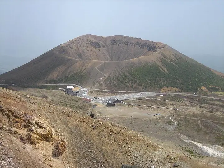
Azuma-Kofuji is a 1,707 m active volcano on Jōdodaira in Bandai-Asahi National Park, Fukushima City, whose elegant Fuji-shaped cone gave it its name — a renaming of the older Suribachi-yama. From the Jōdodaira parking lot off the Bandai-Azuma Skyline, a ten-minute wooden staircase leads to the rim of its roughly 500 m-wide, 70 m-deep crater, and a roughly forty-minute rim loop opens a sweeping view across the Fukushima Basin and the Jōdodaira marsh. Native white pines grow at the southern foot and are spreading up the slopes.
Mount Azuma-Kofuji at a glance
- Weather: The most settled day in the next 7 days is Wed, November 4: clear, gusts up to 8 m/s. Fri, Nov 6, Sat, Nov 7, Sun, Nov 8: strong wind (gusts up to 24 m/s).
- Route: The shortest is Azuma-kofuji Crater Rim Circuit: about 1 h 18 min, 2.4 km, about 130 m of climbing.
Mount Azuma-Kofuji weather (hourly, 14 days)
Sunrise today 06:05, sunset 16:40
| Tue, 11/3 | Wed, 11/4 | Thu, 11/5 | Fri, 11/6 | Sat, 11/7 | Sun, 11/8 | Mon, 11/9 | Tue, 11/10 | Wed, 11/11 | Thu, 11/12 | Fri, 11/13 | Sat, 11/14 | Sun, 11/15 | Mon, 11/16 | Tue, 11/17 | |||||||||||||||||||||||||||||||||||||||||||||||||||||||||||||||||||||||
|---|---|---|---|---|---|---|---|---|---|---|---|---|---|---|---|---|---|---|---|---|---|---|---|---|---|---|---|---|---|---|---|---|---|---|---|---|---|---|---|---|---|---|---|---|---|---|---|---|---|---|---|---|---|---|---|---|---|---|---|---|---|---|---|---|---|---|---|---|---|---|---|---|---|---|---|---|---|---|---|---|---|---|---|---|---|
| Japan time | 15 | 17 | 19 | 21 | 23 | 1 | 3 | 5 | 7 | 9 | 11 | 13 | 15 | 18 | 21 | 0 | 3 | 6 | 9 | 12 | 15 | 18 | 21 | 0 | 3 | 6 | 9 | 12 | 15 | 18 | 21 | 0 | 3 | 6 | 9 | 12 | 15 | 18 | 21 | 0 | 3 | 6 | 9 | 12 | 15 | 18 | 21 | 0 | 3 | 6 | 9 | 15 | 21 | 3 | 9 | 15 | 21 | 3 | 9 | 15 | 21 | 3 | 9 | 15 | 21 | 3 | 9 | 15 | 21 | 3 | 9 | 15 | 21 | 3 | 9 | 15 | 21 | 3 | 9 | 15 | 21 | 3 | 9 | 15 | |
 |  | | | | | |   | |   | | | | |   |   | | |   | | |   | | | | | |   | | | | | |   |   | |   |   | | | | |   | | |   | | | | | |   | | | | | | |   | | | |   | | | | | | | | | |  | | | | | | | | | | | | ||
| Temperature | °C | 4° | 0° | -2° | -2° | -2° | -2° | -2° | -1° | 1° | 5° | 7° | 8° | 7° | 2° | 2° | 3° | 4° | 5° | 6° | 7° | 8° | 6° | 5° | 7° | 5° | 6° | 8° | 9° | 8° | 5° | 4° | 1° | 0° | -1° | -2° | -1° | -2° | -3° | -3° | -3° | -3° | -3° | -1° | 1° | -1° | -2° | -2° | -2° | -3° | -3° | 1° | 2° | -3° | -5° | 1° | 1° | -2° | -1° | -2° | 1° | -2° | -2° | 1° | 2° | -1° | 0° | 0° | -1° | -4° | -4° | 1° | 4° | -2° | -1° | 6° | 7° | 3° | 4° | 7° | 3° | -3° | -4° | -1° | 1° |
| Precipitation | mm | 1.4 | 4.2 | 11 | 7 | 2.9 | 0.2 | 0.3 | 1.0 | 0.2 | 0.5 | 0.2 | 0.7 | 0.5 | 0.8 | 1.0 | 1.3 | 0.9 | 0.2 | 0.1 | 0.3 | 0.3 | 0.1 | 0.1 | 0.8 | 0.9 | 0.1 | 2.3 | 1.8 | 0.1 | 0.2 | 0.5 | 0.2 | 1.1 | 3.9 | 9 | 0.2 | 4.1 | 3.3 | 0.2 | |||||||||||||||||||||||||||||||||||||||||||||
| New snow | cm | 0.1 | 0.6 | 1.0 | 0.8 | 0.1 | 0.1 | 0.2 | <.1 | <.1 | 0.1 | 0.8 | 0.9 | 0.1 | 0.5 | 1.4 | <.1 | <.1 | <.1 | <.1 | <.1 | 0.2 | <.1 | <.1 | <.1 | 0.7 | 0.2 | ||||||||||||||||||||||||||||||||||||||||||||||||||||||||||
| Snow depth | cm | 0 | 0 | 0 | 0 | 0 | 0 | 0 | 0 | 0 | 0 | 0 | 0 | 0 | 0 | 0 | 0 | 0 | 0 | 0 | 0 | 0 | 0 | 0 | 0 | 0 | 0 | 0 | 0 | 0 | 0 | 0 | 0 | 0 | 0 | <1 | <1 | 1 | 1 | <1 | <1 | <1 | <1 | 1 | 1 | <1 | <1 | <1 | <1 | 1 | 2 | 1 | <1 | <1 | <1 | <1 | <1 | <1 | <1 | 2 | <1 | <1 | <1 | <1 | <1 | <1 | <1 | <1 | <1 | <1 | <1 | <1 | <1 | <1 | <1 | <1 | <1 | <1 | <1 | <1 | 0 | <1 | <1 | <1 | <1 |
| Wind | m/s | 4 | 2 | 2 | 2 | 2 | 2 | 2 | 2 | 2 | 1 | 1 | 1 | 2 | 2 | 2 | 2 | 2 | 1 | 2 | 1 | 1 | 1 | 1 | 2 | 2 | 3 | 3 | 4 | 5 | 4 | 4 | 4 | 4 | 4 | 4 | 5 | 5 | 5 | 5 | 5 | 5 | 4 | 4 | 5 | 5 | 3 | 2 | 2 | 2 | 2 | 1 | 2 | 2 | 2 | 1 | 3 | 1 | 3 | 5 | 6 | 3 | 3 | 2 | 2 | 2 | 3 | 5 | 6 | 4 | 3 | 3 | 1 | 1 | 1 | 0 | 0 | 1 | 1 | 2 | 5 | 6 | 4 | 3 | 1 |
| Wind gusts | m/s | 18 | 13 | 11 | 11 | 11 | 10 | 10 | 9 | 8 | 8 | 6 | 5 | 7 | 8 | 8 | 9 | 9 | 9 | 11 | 9 | 7 | 7 | 8 | 10 | 10 | 13 | 16 | 18 | 22 | 21 | 19 | 19 | 19 | 19 | 19 | 24 | 23 | 23 | 23 | 22 | 20 | 20 | 19 | 19 | 20 | 18 | 14 | 12 | 12 | 11 | 10 | 9 | 10 | 11 | 9 | 10 | 10 | 13 | 21 | 22 | 21 | 13 | 13 | 11 | 10 | 14 | 18 | 21 | 20 | 15 | 13 | 10 | 6 | 7 | 7 | 6 | 7 | 9 | 13 | 18 | 24 | 22 | 16 | 10 |
| Wind dir. | ↓ | ↓ | ↓ | ↓ | ↓ | ↓ | ↓ | ↓ | ↓ | ↓ | ↓ | ↓ | ↓ | ↓ | ↓ | ↓ | ↓ | ↓ | ↓ | ↓ | ↓ | ↓ | ↓ | ↓ | ↓ | ↓ | ↓ | ↓ | ↓ | ↓ | ↓ | ↓ | ↓ | ↓ | ↓ | ↓ | ↓ | ↓ | ↓ | ↓ | ↓ | ↓ | ↓ | ↓ | ↓ | ↓ | ↓ | ↓ | ↓ | ↓ | ↓ | ↓ | ↓ | ↓ | ↓ | ↓ | ↓ | ↓ | ↓ | ↓ | ↓ | ↓ | ↓ | ↓ | ↓ | ↓ | ↓ | ↓ | ↓ | ↓ | ↓ | ↓ | ↓ | ↓ | ↓ | ↓ | ↓ | ↓ | ↓ | ↓ | ↓ | ↓ | ↓ | ↓ | |
Mount Azuma-Kofuji hiking routes
Hiking times are estimates calculated from the terrain.
Huts, campsites and lodging near Mount Azuma-Kofuji
Mountain huts
- 吾妻小舎 2026: open May 23–November 5 · reservation required · sleeps 14
- 吾妻小屋
- 酸ヶ平避難小屋 unstaffed · sleeps 30
- 慶応吾妻山荘
- Iegatayama Hut unstaffed · sleeps 10
Campsites
- 浄土平キャンプ場
Lodging
- 微温湯温泉 旅館 二階堂
- Makukawa Onsen Mitoya Ryokan
- 花月ハイランドホテル
- Makukawa Onsen Yoshikuraya Ryokan
- Seishin Sanso 高湯温泉 静心山荘
Lists that include Mount Azuma-Kofuji
Mount Azuma-Kofuji facts
- Also known as
- 摺鉢山 · Azuma-Kofuji
- Elevation
- 1,707 m
- Location
- Fukushima, Fukushima
37.722146, 140.263583 - National Park
- 磐梯朝日国立公園
- Volcano
- Active volcano (吾妻山)
- Website
- www.env.go.jp
- Access Information
- www.env.go.jp
- Wikipedia
- ja.wikipedia.org