
Mount Adatara
安達太良山
Kōriyama, Fukushima / Nihonmatsu, Fukushima · Elevation 1,700 m
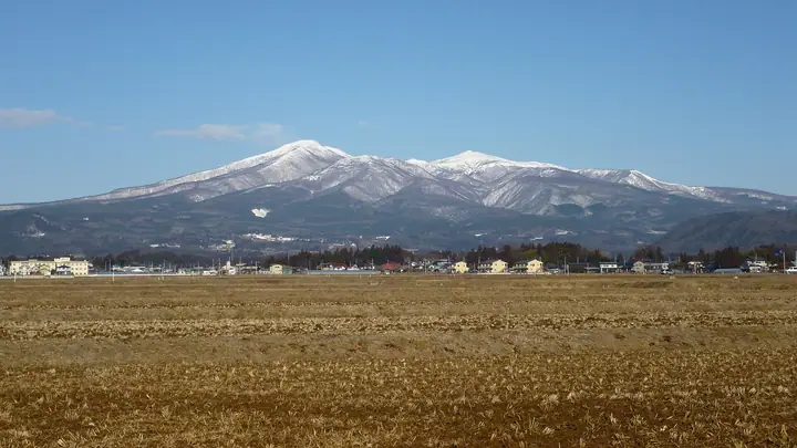
Mount Adatara is a 1,700 m active volcano spanning Nihonmatsu and Koriyama cities in Fukushima Prefecture, set within Bandai-Asahi National Park. Its nipple-shaped summit knob has earned it the local nickname "Chikubi-san," and the mountain is famously the setting of the "real sky" in Takamura Kōtarō's poem cycle Chieko-shō. It holds an official mountain-opening ceremony on the third Sunday of May. The Adatara ropeway lifts hikers to Yakushidake at 1,350 m, leaving roughly 90 minutes of walking to the summit. Areas around Numanotaira and the western slopes near Kuroganegoya are closed due to toxic volcanic gases. Rhododendrons bloom in early summer.
Mount Adatara at a glance
- Weather: The most settled day in the next 7 days is Wed, November 4: clear, gusts up to 8 m/s. Fri, Nov 6, Sat, Nov 7, Sun, Nov 8: strong wind (gusts up to 21 m/s).
- Route: The shortest is Mount Adatara Return from Yakushidake Panorama Park via the Sennyodaira Junction: about 3 h 32 min, 5.8 km, about 620 m of climbing.
Mount Adatara weather (hourly, 14 days)
Sunrise today 06:05, sunset 16:40
| Tue, 11/3 | Wed, 11/4 | Thu, 11/5 | Fri, 11/6 | Sat, 11/7 | Sun, 11/8 | Mon, 11/9 | Tue, 11/10 | Wed, 11/11 | Thu, 11/12 | Fri, 11/13 | Sat, 11/14 | Sun, 11/15 | Mon, 11/16 | Tue, 11/17 | |||||||||||||||||||||||||||||||||||||||||||||||||||||||||||||||||||||||
|---|---|---|---|---|---|---|---|---|---|---|---|---|---|---|---|---|---|---|---|---|---|---|---|---|---|---|---|---|---|---|---|---|---|---|---|---|---|---|---|---|---|---|---|---|---|---|---|---|---|---|---|---|---|---|---|---|---|---|---|---|---|---|---|---|---|---|---|---|---|---|---|---|---|---|---|---|---|---|---|---|---|---|---|---|---|
| Japan time | 15 | 17 | 19 | 21 | 23 | 1 | 3 | 5 | 7 | 9 | 11 | 13 | 15 | 18 | 21 | 0 | 3 | 6 | 9 | 12 | 15 | 18 | 21 | 0 | 3 | 6 | 9 | 12 | 15 | 18 | 21 | 0 | 3 | 6 | 9 | 12 | 15 | 18 | 21 | 0 | 3 | 6 | 9 | 12 | 15 | 18 | 21 | 0 | 3 | 6 | 9 | 15 | 21 | 3 | 9 | 15 | 21 | 3 | 9 | 15 | 21 | 3 | 9 | 15 | 21 | 3 | 9 | 15 | 21 | 3 | 9 | 15 | 21 | 3 | 9 | 15 | 21 | 3 | 9 | 15 | 21 | 3 | 9 | 15 | |
 |  | |   | | | | |   | | | | | |   |   | | |   | |   | | | | | | | |   | | | | |   |   |   |   | |   |   | | | | | | | | | | |   | |   | | | | | | | | | |   | | | | | | | | | |  | | | | | | | | | | | | ||
| Temperature | °C | 4° | -1° | -2° | -3° | -3° | -3° | -3° | -3° | 0° | 5° | 6° | 7° | 6° | 1° | 2° | 2° | 3° | 5° | 5° | 7° | 8° | 5° | 4° | 6° | 5° | 6° | 7° | 8° | 7° | 4° | 3° | 1° | -1° | -2° | -2° | -2° | -2° | -4° | -4° | -4° | -4° | -4° | -2° | 1° | 0° | -3° | -3° | -3° | -3° | -4° | 0° | 1° | -3° | -6° | 0° | 0° | -3° | -2° | -2° | 1° | -2° | -3° | 0° | 1° | -1° | -1° | 0° | -1° | -4° | -4° | 1° | 3° | -3° | -2° | 5° | 6° | 2° | 5° | 7° | 3° | -3° | -4° | -1° | 1° |
| Precipitation | mm | 2.1 | 5 | 11 | 7 | 2.7 | 0.5 | 1.3 | 0.2 | 0.8 | 0.3 | 0.3 | 0.6 | 0.8 | 1.0 | 0.6 | 0.6 | 0.5 | 0.2 | 0.2 | 2.1 | 1.8 | 0.2 | 0.1 | 0.2 | 0.9 | 3.6 | 9 | 0.2 | 2.4 | 1.2 | 0.1 | |||||||||||||||||||||||||||||||||||||||||||||||||||||
| New snow | cm | 0.2 | 0.7 | 0.8 | 0.5 | <.1 | <.1 | <.1 | <.1 | <.1 | <.1 | <.1 | <.1 | 0.5 | 0.4 | 0.2 | 0.6 | 1.5 | <.1 | <.1 | <.1 | <.1 | <.1 | 0.1 | <.1 | <.1 | <.1 | 0.1 | <.1 | ||||||||||||||||||||||||||||||||||||||||||||||||||||||||
| Snow depth | cm | 0 | 0 | 0 | 0 | 0 | 0 | 0 | 0 | 0 | 0 | 0 | 0 | 0 | 0 | 0 | 0 | 0 | 0 | 0 | 0 | 0 | 0 | 0 | 0 | 0 | 0 | 0 | 0 | 0 | 0 | 0 | 0 | 0 | 0 | <1 | <1 | <1 | <1 | <1 | <1 | <1 | <1 | <1 | <1 | <1 | <1 | <1 | <1 | <1 | <1 | <1 | <1 | <1 | <1 | <1 | <1 | <1 | <1 | <1 | <1 | <1 | <1 | <1 | <1 | <1 | <1 | <1 | <1 | <1 | <1 | <1 | <1 | <1 | <1 | <1 | <1 | <1 | <1 | <1 | 0 | <1 | <1 | <1 | <1 |
| Wind | m/s | 3 | 2 | 3 | 2 | 3 | 2 | 2 | 2 | 2 | 1 | 1 | 2 | 2 | 1 | 1 | 1 | 1 | 0 | 2 | 1 | 1 | 1 | 2 | 2 | 2 | 3 | 3 | 5 | 6 | 6 | 6 | 3 | 5 | 4 | 4 | 5 | 6 | 6 | 6 | 6 | 5 | 4 | 5 | 5 | 5 | 2 | 2 | 2 | 2 | 2 | 1 | 1 | 2 | 2 | 1 | 3 | 1 | 4 | 3 | 5 | 2 | 3 | 2 | 3 | 2 | 3 | 4 | 4 | 3 | 3 | 1 | 1 | 1 | 2 | 1 | 1 | 1 | 0 | 2 | 3 | 4 | 3 | 1 | 0 |
| Wind gusts | m/s | 14 | 11 | 10 | 10 | 9 | 10 | 9 | 9 | 8 | 7 | 5 | 6 | 6 | 6 | 6 | 7 | 7 | 6 | 8 | 7 | 5 | 6 | 6 | 9 | 9 | 13 | 16 | 19 | 21 | 21 | 22 | 21 | 20 | 19 | 17 | 21 | 21 | 22 | 22 | 22 | 20 | 19 | 16 | 18 | 18 | 15 | 11 | 10 | 9 | 8 | 8 | 8 | 8 | 9 | 8 | 7 | 7 | 15 | 21 | 19 | 18 | 10 | 10 | 12 | 11 | 13 | 15 | 17 | 15 | 12 | 10 | 7 | 6 | 8 | 8 | 7 | 7 | 6 | 11 | 14 | 19 | 15 | 11 | 7 |
| Wind dir. | ↓ | ↓ | ↓ | ↓ | ↓ | ↓ | ↓ | ↓ | ↓ | ↓ | ↓ | ↓ | ↓ | ↓ | ↓ | ↓ | ↓ | ↓ | ↓ | ↓ | ↓ | ↓ | ↓ | ↓ | ↓ | ↓ | ↓ | ↓ | ↓ | ↓ | ↓ | ↓ | ↓ | ↓ | ↓ | ↓ | ↓ | ↓ | ↓ | ↓ | ↓ | ↓ | ↓ | ↓ | ↓ | ↓ | ↓ | ↓ | ↓ | ↓ | ↓ | ↓ | ↓ | ↓ | ↓ | ↓ | ↓ | ↓ | ↓ | ↓ | ↓ | ↓ | ↓ | ↓ | ↓ | ↓ | ↓ | ↓ | ↓ | ↓ | ↓ | ↓ | ↓ | ↓ | ↓ | ↓ | ↓ | ↓ | ↓ | ↓ | ↓ | ↓ | ↓ | ↓ | |
Mount Adatara live cameras
Mount Adatara hiking routes
- Mount Adatara Return from Yakushidake Panorama Park via the Sennyodaira Junction 5.8 km · Ascent 621 m 中間降り場 (Aerialway station) → あだたら山ロープウエイ山頂駅 (Aerialway station)
- Mount Adatara via Numanotaira Crater and Kurogane Hut from Ropeway Summit Station to Okudake 9.2 km · Ascent 365 m あだたら山ロープウエイ山頂駅 (Aerialway station) → あだたら山ロープウェイ山麓駅 (Aerialway station) (parking)
- Mount Adatara and Mount Tetsu Loop from Numajiri 12.1 km · Ascent 902 m 沼尻登山口 (parking)
Hiking times are estimates calculated from the terrain.
Huts, campsites and lodging near Mount Adatara
Mountain huts
Campsites
- Abandoned building
Lodging
- ホテルプルミエール箕輪
- マウント磐梯
Lists that include Mount Adatara
100 Famous Japanese Mountains · Japan 200 Famous Mountains · Japan's 300 Famous Mountains · 100 Famous Mountains of Flowers · New Japan 100 Famous Mountains · Illustrated Collection of Japan's Famous Mountains · 100 Famous Hot Spring Mountains · Tohoku 100 Famous Mountains · Utsukushima 100 Famous Mountains (Fukushima Prefecture) · Aizu 100 Famous Mountains · 30 Peaks of Fukushima · Elevations of 1003 Mountains of Japan · 1000 Mountains of Japan
Mount Adatara facts
- Also known as
- 乳首山
- Elevation
- 1,700 m
- Location
- Kōriyama, Fukushima / Nihonmatsu, Fukushima
37.621111, 140.287873 - National Park
- 磐梯朝日国立公園
- Volcano
- Active volcano (安達太良山)
- Website
- www.nihonmatsu-kanko.jp
- Trail Map
- www.nihonmatsu-kanko.jp
- Wikipedia
- ja.wikipedia.org