
Mount Higashi-Azuma
東吾妻山
Fukushima, Fukushima / Inawashiro, Fukushima · Elevation 1,975 m
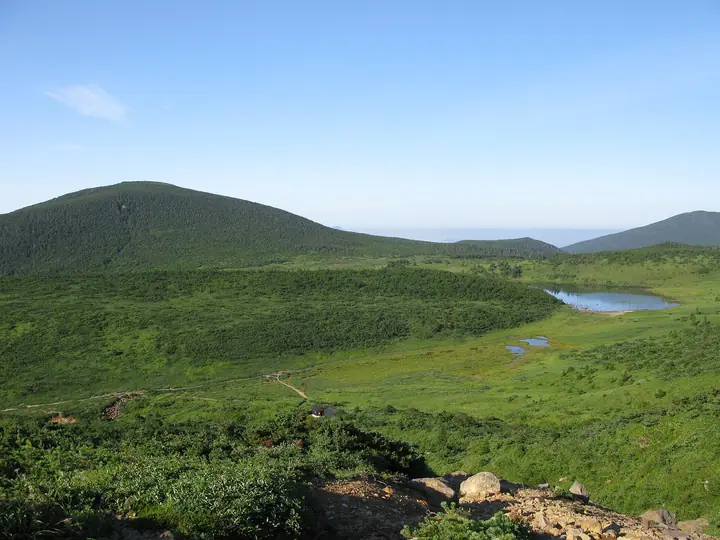
Mount Higashi-Azuma (1,974.7 m) is a gentle stratovolcano at the southern end of the Azuma Mountains, on the boundary between Fukushima City and Inawashiro Town. Within Bandai-Asahi National Park, it sits on Japan's central watershed dividing the Pacific and Japan Sea drainages. Slopes of Maries' fir and Japanese hemlock give way to dwarf pine near the summit, and the popular route via Ubagahara from Jōdodaira offers panoramic views of Mount Bandai, Lake Inawashiro and Mount Issaikyō. The descent toward Keibadaira passes an observation deck, wetlands and ponds before reaching Torikodairaguchi.
Mount Higashi-Azuma at a glance
- Weather: The most settled day in the next 7 days is Wed, November 4: clear, gusts up to 8 m/s. Fri, Nov 6, Sat, Nov 7, Sun, Nov 8: strong wind (gusts up to 24 m/s).
- Route: The shortest is Azuma Volcano and Marsh Walk from Mount Issaikyo above the Witch's Eye round to Mount Higashi-Azuma: about 5 h 36 min, 10.0 km, about 590 m of climbing.
Mount Higashi-Azuma weather (hourly, 14 days)
Sunrise today 06:06, sunset 16:40
| Tue, 11/3 | Wed, 11/4 | Thu, 11/5 | Fri, 11/6 | Sat, 11/7 | Sun, 11/8 | Mon, 11/9 | Tue, 11/10 | Wed, 11/11 | Thu, 11/12 | Fri, 11/13 | Sat, 11/14 | Sun, 11/15 | Mon, 11/16 | Tue, 11/17 | |||||||||||||||||||||||||||||||||||||||||||||||||||||||||||||||||||||||
|---|---|---|---|---|---|---|---|---|---|---|---|---|---|---|---|---|---|---|---|---|---|---|---|---|---|---|---|---|---|---|---|---|---|---|---|---|---|---|---|---|---|---|---|---|---|---|---|---|---|---|---|---|---|---|---|---|---|---|---|---|---|---|---|---|---|---|---|---|---|---|---|---|---|---|---|---|---|---|---|---|---|---|---|---|---|
| Japan time | 15 | 17 | 19 | 21 | 23 | 1 | 3 | 5 | 7 | 9 | 11 | 13 | 15 | 18 | 21 | 0 | 3 | 6 | 9 | 12 | 15 | 18 | 21 | 0 | 3 | 6 | 9 | 12 | 15 | 18 | 21 | 0 | 3 | 6 | 9 | 12 | 15 | 18 | 21 | 0 | 3 | 6 | 9 | 12 | 15 | 18 | 21 | 0 | 3 | 6 | 9 | 15 | 21 | 3 | 9 | 15 | 21 | 3 | 9 | 15 | 21 | 3 | 9 | 15 | 21 | 3 | 9 | 15 | 21 | 3 | 9 | 15 | 21 | 3 | 9 | 15 | 21 | 3 | 9 | 15 | 21 | 3 | 9 | 15 | |
 |  | | | | | |   | |   | | | | |   |   | | |   | | |   | | | | | |   | | | | | |   |   | |   |   | | | | |   | | |   | | | | | |   | | | | | | |   | | | |   | | | | | | | | | |  | | | | | | | | | | | | ||
| Temperature | °C | 3° | -2° | -3° | -3° | -4° | -4° | -4° | -3° | -1° | 3° | 5° | 6° | 5° | 0° | 1° | 1° | 2° | 3° | 4° | 5° | 6° | 4° | 3° | 5° | 4° | 5° | 7° | 7° | 7° | 4° | 2° | 0° | -2° | -3° | -4° | -3° | -4° | -5° | -5° | -5° | -5° | -5° | -3° | -1° | -2° | -4° | -4° | -4° | -4° | -5° | -1° | 0° | -5° | -7° | -1° | -1° | -4° | -3° | -3° | -1° | -4° | -4° | -1° | 0° | -3° | -2° | -2° | -3° | -6° | -5° | -1° | 2° | -4° | -3° | 5° | 6° | 1° | 3° | 6° | 1° | -5° | -6° | -3° | 0° |
| Precipitation | mm | 1.4 | 4.2 | 11 | 7 | 2.9 | 0.2 | 0.3 | 1.0 | 0.2 | 0.5 | 0.2 | 0.7 | 0.5 | 0.8 | 1.0 | 1.3 | 0.9 | 0.2 | 0.1 | 0.3 | 0.3 | 0.1 | 0.1 | 0.8 | 0.9 | 0.1 | 2.3 | 1.8 | 0.1 | 0.2 | 0.5 | 0.2 | 1.1 | 3.9 | 9 | 0.2 | 4.1 | 3.3 | 0.2 | |||||||||||||||||||||||||||||||||||||||||||||
| New snow | cm | 0.1 | 0.6 | 1.0 | 0.8 | 0.1 | 0.1 | 0.2 | <.1 | <.1 | 0.1 | 0.8 | 0.9 | 0.1 | 0.5 | 1.4 | <.1 | <.1 | <.1 | <.1 | <.1 | 0.2 | <.1 | <.1 | <.1 | 0.7 | 0.2 | ||||||||||||||||||||||||||||||||||||||||||||||||||||||||||
| Snow depth | cm | 0 | 0 | 0 | 0 | 0 | 0 | 0 | 0 | 0 | 0 | 0 | 0 | 0 | 0 | 0 | 0 | 0 | 0 | 0 | 0 | 0 | 0 | 0 | 0 | 0 | 0 | 0 | 0 | 0 | 0 | 0 | 0 | 0 | 0 | <1 | <1 | 1 | 1 | <1 | <1 | <1 | <1 | 1 | 1 | <1 | <1 | <1 | <1 | 1 | 2 | 1 | <1 | <1 | <1 | <1 | <1 | <1 | <1 | 2 | <1 | <1 | <1 | <1 | <1 | <1 | <1 | <1 | <1 | <1 | <1 | <1 | <1 | <1 | <1 | <1 | <1 | <1 | <1 | <1 | 0 | <1 | <1 | <1 | <1 |
| Wind | m/s | 4 | 2 | 2 | 2 | 2 | 2 | 2 | 2 | 2 | 1 | 1 | 1 | 2 | 2 | 2 | 2 | 2 | 1 | 2 | 1 | 1 | 1 | 1 | 2 | 2 | 3 | 3 | 4 | 5 | 4 | 4 | 4 | 4 | 4 | 4 | 5 | 5 | 5 | 5 | 5 | 5 | 4 | 4 | 5 | 5 | 3 | 2 | 2 | 2 | 2 | 1 | 2 | 2 | 2 | 1 | 3 | 1 | 3 | 5 | 6 | 3 | 3 | 2 | 2 | 2 | 3 | 5 | 6 | 4 | 3 | 3 | 1 | 1 | 1 | 0 | 0 | 1 | 1 | 2 | 5 | 6 | 4 | 3 | 1 |
| Wind gusts | m/s | 18 | 13 | 11 | 11 | 11 | 10 | 10 | 9 | 8 | 8 | 6 | 5 | 7 | 8 | 8 | 9 | 9 | 9 | 11 | 9 | 7 | 7 | 8 | 10 | 10 | 13 | 16 | 18 | 22 | 21 | 19 | 19 | 19 | 19 | 19 | 24 | 23 | 23 | 23 | 22 | 20 | 20 | 19 | 19 | 20 | 18 | 14 | 12 | 12 | 11 | 10 | 9 | 10 | 11 | 9 | 10 | 10 | 13 | 21 | 22 | 21 | 13 | 13 | 11 | 10 | 14 | 18 | 21 | 20 | 15 | 13 | 10 | 6 | 7 | 7 | 6 | 7 | 9 | 13 | 18 | 24 | 22 | 16 | 10 |
| Wind dir. | ↓ | ↓ | ↓ | ↓ | ↓ | ↓ | ↓ | ↓ | ↓ | ↓ | ↓ | ↓ | ↓ | ↓ | ↓ | ↓ | ↓ | ↓ | ↓ | ↓ | ↓ | ↓ | ↓ | ↓ | ↓ | ↓ | ↓ | ↓ | ↓ | ↓ | ↓ | ↓ | ↓ | ↓ | ↓ | ↓ | ↓ | ↓ | ↓ | ↓ | ↓ | ↓ | ↓ | ↓ | ↓ | ↓ | ↓ | ↓ | ↓ | ↓ | ↓ | ↓ | ↓ | ↓ | ↓ | ↓ | ↓ | ↓ | ↓ | ↓ | ↓ | ↓ | ↓ | ↓ | ↓ | ↓ | ↓ | ↓ | ↓ | ↓ | ↓ | ↓ | ↓ | ↓ | ↓ | ↓ | ↓ | ↓ | ↓ | ↓ | ↓ | ↓ | ↓ | ↓ | |
Mount Higashi-Azuma hiking routes
Hiking times are estimates calculated from the terrain.
Huts, campsites and lodging near Mount Higashi-Azuma
Mountain huts
- 酸ヶ平避難小屋 unstaffed · sleeps 30
- 吾妻小屋
- 吾妻小舎 2026: open May 23–November 5 · reservation required · sleeps 14
- Yachidai Emergency Hut unstaffed · sleeps 20
- Iegatayama Hut unstaffed · sleeps 10
Campsites
- 浄土平キャンプ場
Lodging
- Makukawa Onsen Mitoya Ryokan
- Makukawa Onsen Yoshikuraya Ryokan
Lists that include Mount Higashi-Azuma
Utsukushima 100 Famous Mountains (Fukushima Prefecture) · Aizu 100 Famous Mountains · Elevations of 1003 Mountains of Japan
Mount Higashi-Azuma facts
- Elevation
- 1,975 m
- Location
- Fukushima, Fukushima / Inawashiro, Fukushima
37.711711, 140.230291 - National Park
- 磐梯朝日国立公園
- Volcano
- Active volcano (吾妻山)
- Website
- www.jododaira-vc.jp
- Trail Map
- www.env.go.jp
- Access Information
- www.env.go.jp
- Wikipedia
- ja.wikipedia.org