
Mount Nishi-Azuma
西吾妻山
Yonezawa, Yamagata / Kitashiobara, Fukushima · Elevation 2,035 m
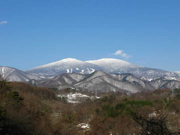
Mount Nishi-Azuma is the highest peak of the Azuma Range at 2035 m, on the border of Yonezawa in Yamagata and Kitashiobara in Fukushima, within Bandai-Asahi National Park. Its gently rounded summit is covered by coniferous forest, while small ponds and wetlands dot the surrounding ridges. Summer highlights include chinguruma and cotton grass, and winter brings ice-encrusted Maries’ firs. Approaches start from Grandeco and Urabandai on the Fukushima side or use the Tengendai Kogen ropeway on the Yamagata side.
Mount Nishi-Azuma at a glance
- Weather: The most settled day in the next 7 days is Wed, November 4: clear, gusts up to 6 m/s. Fri, Nov 6, Sat, Nov 7, Sun, Nov 8: strong wind (gusts up to 25 m/s).
- Route: The shortest is Tengendai Hokubōdai–Mount Nishiazuma Return: about 3 h 27 min, 6.0 km, about 390 m of climbing.
Mount Nishi-Azuma weather (hourly, 14 days)
Sunrise today 06:06, sunset 16:40
| Tue, 11/3 | Wed, 11/4 | Thu, 11/5 | Fri, 11/6 | Sat, 11/7 | Sun, 11/8 | Mon, 11/9 | Tue, 11/10 | Wed, 11/11 | Thu, 11/12 | Fri, 11/13 | Sat, 11/14 | Sun, 11/15 | Mon, 11/16 | Tue, 11/17 | |||||||||||||||||||||||||||||||||||||||||||||||||||||||||||||||||||||||
|---|---|---|---|---|---|---|---|---|---|---|---|---|---|---|---|---|---|---|---|---|---|---|---|---|---|---|---|---|---|---|---|---|---|---|---|---|---|---|---|---|---|---|---|---|---|---|---|---|---|---|---|---|---|---|---|---|---|---|---|---|---|---|---|---|---|---|---|---|---|---|---|---|---|---|---|---|---|---|---|---|---|---|---|---|---|
| Japan time | 15 | 17 | 19 | 21 | 23 | 1 | 3 | 5 | 7 | 9 | 11 | 13 | 15 | 18 | 21 | 0 | 3 | 6 | 9 | 12 | 15 | 18 | 21 | 0 | 3 | 6 | 9 | 12 | 15 | 18 | 21 | 0 | 3 | 6 | 9 | 12 | 15 | 18 | 21 | 0 | 3 | 6 | 9 | 12 | 15 | 18 | 21 | 0 | 3 | 6 | 9 | 15 | 21 | 3 | 9 | 15 | 21 | 3 | 9 | 15 | 21 | 3 | 9 | 15 | 21 | 3 | 9 | 15 | 21 | 3 | 9 | 15 | 21 | 3 | 9 | 15 | 21 | 3 | 9 | 15 | 21 | 3 | 9 | 15 | |
 |  | | | | | |   | |   | | | | |   |   | | |   | | | | | | | | |   | | | | | |   |   | |   |   |   | | | | | | |   | | | | | |   | | | | | | | | | | |   |   | | | | | | | | |  | | | | | | | | | | | | ||
| Temperature | °C | 2° | -2° | -3° | -3° | -4° | -4° | -3° | -3° | -1° | 3° | 5° | 6° | 5° | -1° | 1° | 1° | 2° | 3° | 4° | 5° | 7° | 4° | 3° | 5° | 4° | 5° | 5° | 6° | 5° | 3° | 1° | -1° | -2° | -3° | -4° | -3° | -4° | -5° | -5° | -5° | -5° | -5° | -3° | -2° | -3° | -4° | -5° | -5° | -5° | -5° | -2° | -1° | -5° | -7° | -1° | 0° | -3° | -4° | -4° | -2° | -4° | -4° | -2° | -1° | -3° | -2° | -3° | -4° | -6° | -6° | -1° | 2° | -4° | -2° | 5° | 5° | 1° | 3° | 5° | 1° | -6° | -7° | -4° | -1° |
| Precipitation | mm | 1.2 | 3.3 | 11 | 7 | 2.7 | 0.1 | 0.1 | 0.6 | 1.9 | 0.3 | 0.8 | 0.5 | 0.9 | 0.6 | 0.9 | 1.1 | 1.2 | 1.4 | 0.1 | 0.2 | 0.4 | 0.2 | 0.1 | 0.2 | 0.9 | 1.2 | 0.2 | 0.1 | 0.1 | 3.7 | 2.6 | 0.4 | 0.2 | 0.4 | 0.8 | 0.4 | 1.7 | 0.3 | 0.2 | 3.8 | 8 | 0.4 | 4.5 | 3.8 | 0.3 | |||||||||||||||||||||||||||||||||||||||
| New snow | cm | 0.3 | 0.9 | 1.1 | 1.4 | 0.1 | 0.2 | 0.3 | 0.1 | <.1 | 0.1 | 0.9 | 1.2 | 0.1 | 1.6 | 2.6 | <.1 | <.1 | 0.2 | 0.2 | <.1 | 0.4 | 0.2 | 0.2 | <.1 | 1.3 | 0.3 | ||||||||||||||||||||||||||||||||||||||||||||||||||||||||||
| Snow depth | cm | 0 | 0 | 0 | 0 | 0 | 0 | 0 | 0 | 0 | 0 | 0 | 0 | 0 | 0 | 0 | 0 | 0 | 0 | 0 | 0 | 0 | 0 | 0 | 0 | 0 | 0 | 0 | 0 | 0 | 0 | 0 | 0 | 0 | 0 | <1 | 1 | 2 | 2 | 1 | 1 | 1 | 1 | 2 | 2 | 2 | 2 | 1 | 2 | 2 | 3 | 3 | 2 | 1 | 1 | 1 | 1 | 1 | 2 | 4 | 3 | 3 | 3 | 2 | 2 | 2 | 2 | 2 | 2 | 2 | 2 | 2 | 2 | 2 | 2 | 2 | <1 | <1 | <1 | <1 | 0 | <1 | <1 | <1 | <1 |
| Wind | m/s | 4 | 2 | 1 | 1 | 1 | 1 | 1 | 1 | 1 | 1 | 1 | 0 | 1 | 2 | 3 | 3 | 2 | 2 | 3 | 2 | 1 | 1 | 2 | 2 | 2 | 3 | 5 | 5 | 6 | 5 | 4 | 4 | 4 | 3 | 4 | 6 | 6 | 6 | 6 | 5 | 5 | 4 | 4 | 5 | 5 | 3 | 2 | 1 | 1 | 1 | 1 | 2 | 1 | 0 | 0 | 3 | 2 | 3 | 4 | 6 | 4 | 3 | 2 | 3 | 2 | 4 | 5 | 6 | 4 | 3 | 2 | 1 | 1 | 1 | 1 | 1 | 1 | 1 | 3 | 6 | 6 | 4 | 3 | 1 |
| Wind gusts | m/s | 17 | 13 | 9 | 8 | 7 | 7 | 7 | 7 | 6 | 6 | 6 | 5 | 5 | 8 | 9 | 11 | 11 | 9 | 12 | 11 | 7 | 7 | 8 | 10 | 10 | 14 | 17 | 19 | 23 | 21 | 20 | 16 | 17 | 16 | 18 | 24 | 25 | 22 | 22 | 21 | 20 | 19 | 17 | 18 | 19 | 16 | 11 | 9 | 9 | 7 | 8 | 9 | 8 | 7 | 6 | 10 | 11 | 15 | 20 | 22 | 20 | 15 | 10 | 11 | 11 | 16 | 18 | 19 | 19 | 15 | 11 | 9 | 6 | 7 | 8 | 7 | 8 | 9 | 14 | 19 | 23 | 19 | 15 | 9 |
| Wind dir. | ↓ | ↓ | ↓ | ↓ | ↓ | ↓ | ↓ | ↓ | ↓ | ↓ | ↓ | ↓ | ↓ | ↓ | ↓ | ↓ | ↓ | ↓ | ↓ | ↓ | ↓ | ↓ | ↓ | ↓ | ↓ | ↓ | ↓ | ↓ | ↓ | ↓ | ↓ | ↓ | ↓ | ↓ | ↓ | ↓ | ↓ | ↓ | ↓ | ↓ | ↓ | ↓ | ↓ | ↓ | ↓ | ↓ | ↓ | ↓ | ↓ | ↓ | ↓ | ↓ | ↓ | ↓ | ↓ | ↓ | ↓ | ↓ | ↓ | ↓ | ↓ | ↓ | ↓ | ↓ | ↓ | ↓ | ↓ | ↓ | ↓ | ↓ | ↓ | ↓ | ↓ | ↓ | ↓ | ↓ | ↓ | ↓ | ↓ | ↓ | ↓ | ↓ | ↓ | ↓ | |
Mount Nishi-Azuma hiking routes
- Tengendai Hokubōdai–Mount Nishiazuma Return 6.0 km · Ascent 390 m 天元台つがもりリフト(上) (Aerialway station)
- Nishi-Daiten and Mount Nishi-Azuma from Grandeco 7.6 km · Ascent 850 m 裏磐梯ロープウエイ山頂駅 (Aerialway station)
Hiking times are estimates calculated from the terrain.
Huts, campsites and lodging near Mount Nishi-Azuma
Mountain huts
Lodging
- Shintakayu Onsen
- Alb Tengendai
- 大平温泉 滝見屋
- ホテルグランデコ
- 白布温泉 西屋
Lists that include Mount Nishi-Azuma
100 Famous Japanese Mountains · Japan 200 Famous Mountains · Japan's 300 Famous Mountains · New Japan 100 Famous Mountains · 100 Famous Hot Spring Mountains · Tohoku 100 Famous Mountains · Yamagata 100 Famous Mountains · Utsukushima 100 Famous Mountains (Fukushima Prefecture) · Aizu 100 Famous Mountains · 30 Peaks of Fukushima · Elevations of 1003 Mountains of Japan · 1000 Mountains of Japan
Mount Nishi-Azuma facts
- Also known as
- Nishiazuma Yama
- Elevation
- 2,035 m
- Location
- Yonezawa, Yamagata / Kitashiobara, Fukushima
37.738188, 140.140411 - National Park
- 磐梯朝日国立公園
- Volcano
- Active volcano (吾妻山)
- Website
- urabandai-vc.jp
- Trail Map
- www.green.tengendai.jp (PDF)
- Access Information
- www.green.tengendai.jp
- Wikipedia
- ja.wikipedia.org