
Jakotsudake
蛇骨岳
Komoro, Nagano / Tsumagoi, Gunma · Elevation 2,366 m
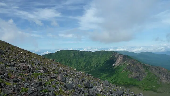
Jakotsudake (2,366 m) is a peak on the first outer rim of the active volcano Mt. Asama, straddling Tsumagoi (Gunma) and Komoro (Nagano). It rises along the ridge northeast of Mt. Kurofu, the rim's high point, and is typically climbed as part of the outer-rim traverse from Kurumazaka Pass. The area lies within Joshin'etsu-kōgen National Park.
Jakotsudake at a glance
- Weather: The most settled day in the next 7 days is Wed, November 4: clear, gusts up to 8 m/s. Sat, Nov 7: strong wind (gusts up to 17 m/s).
- Route: The shortest is Asama First Outer Rim Loop from Tengu Onsen via the J-Band, Kurofuyama and Kusasuberi: about 8 h 13 min, 13.6 km, about 1,120 m of climbing.
Jakotsudake weather (hourly, 14 days)
Sunrise today 06:10, sunset 16:49
| Tue, 11/3 | Wed, 11/4 | Thu, 11/5 | Fri, 11/6 | Sat, 11/7 | Sun, 11/8 | Mon, 11/9 | Tue, 11/10 | Wed, 11/11 | Thu, 11/12 | Fri, 11/13 | Sat, 11/14 | Sun, 11/15 | Mon, 11/16 | Tue, 11/17 | |||||||||||||||||||||||||||||||||||||||||||||||||||||||||||||||||||||||
|---|---|---|---|---|---|---|---|---|---|---|---|---|---|---|---|---|---|---|---|---|---|---|---|---|---|---|---|---|---|---|---|---|---|---|---|---|---|---|---|---|---|---|---|---|---|---|---|---|---|---|---|---|---|---|---|---|---|---|---|---|---|---|---|---|---|---|---|---|---|---|---|---|---|---|---|---|---|---|---|---|---|---|---|---|---|
| Japan time | 15 | 17 | 19 | 21 | 23 | 1 | 3 | 5 | 7 | 9 | 11 | 13 | 15 | 18 | 21 | 0 | 3 | 6 | 9 | 12 | 15 | 18 | 21 | 0 | 3 | 6 | 9 | 12 | 15 | 18 | 21 | 0 | 3 | 6 | 9 | 12 | 15 | 18 | 21 | 0 | 3 | 6 | 9 | 12 | 15 | 18 | 21 | 0 | 3 | 6 | 9 | 15 | 21 | 3 | 9 | 15 | 21 | 3 | 9 | 15 | 21 | 3 | 9 | 15 | 21 | 3 | 9 | 15 | 21 | 3 | 9 | 15 | 21 | 3 | 9 | 15 | 21 | 3 | 9 | 15 | 21 | 3 | 9 | 15 | |
  |   | |   | | | | | | |  | |   |   | |   | | |   | | | | | | |   | | | | | | | | | | | | | | | | | | | | | | | | | | | | | | | |   |   | | | | | | | |   | | |  | | | | | |   | |   | | | | | | | ||
| Temperature | °C | 3° | -1° | -4° | -5° | -5° | -4° | -4° | -4° | -3° | 2° | 5° | 6° | 4° | 0° | -1° | 0° | 0° | 1° | 3° | 7° | 7° | 3° | 4° | 3° | 3° | 2° | 7° | 9° | 7° | 2° | 0° | -1° | -2° | -3° | -1° | 0° | -2° | -6° | -7° | -7° | -7° | -8° | -2° | 1° | 0° | -4° | -5° | -5° | -4° | -5° | 0° | 1° | -3° | -4° | -2° | 0° | -4° | -6° | -6° | -5° | -6° | -8° | -2° | 1° | -7° | -4° | -3° | -4° | -9° | -8° | 0° | 4° | -4° | -3° | 3° | 5° | 0° | 2° | 5° | 2° | -5° | -8° | -2° | 2° |
| Precipitation | mm | 0.7 | 9 | 3.8 | 1.7 | 1.0 | 0.2 | 0.7 | 1.2 | 0.3 | 1.9 | 1.8 | 1.6 | 0.1 | 0.1 | 7 | 6 | 0.3 | 0.1 | ||||||||||||||||||||||||||||||||||||||||||||||||||||||||||||||||||
| New snow | cm | <.1 | <.1 | <.1 | <.1 | <.1 | 1.8 | 1.8 | 1.5 | <.1 | <.1 | <.1 | |||||||||||||||||||||||||||||||||||||||||||||||||||||||||||||||||||||||||
| Snow depth | cm | 0 | 0 | 0 | 0 | 0 | 0 | 0 | 0 | 0 | 0 | 0 | 0 | 0 | 0 | 0 | 0 | 0 | 0 | 0 | 0 | 0 | 0 | 0 | 0 | 0 | 0 | 0 | 0 | 0 | 0 | 0 | 0 | 0 | 0 | 0 | 0 | 0 | 0 | 0 | 0 | 0 | 0 | 0 | 0 | 0 | 0 | 0 | 0 | 0 | 0 | 0 | 0 | 0 | 0 | 0 | 0 | 0 | <1 | 2 | 3 | 2 | 2 | 2 | 1 | 1 | 1 | 1 | <1 | <1 | <1 | <1 | <1 | <1 | <1 | <1 | <1 | 0 | 0 | 0 | 0 | 0 | 0 | 0 | 0 |
| Wind | m/s | 1 | 1 | 0 | 1 | 0 | 1 | 0 | 0 | 0 | 1 | 2 | 2 | 2 | 3 | 2 | 2 | 2 | 1 | 1 | 1 | 0 | 1 | 0 | 1 | 1 | 1 | 3 | 4 | 3 | 2 | 3 | 3 | 4 | 3 | 3 | 5 | 3 | 2 | 1 | 2 | 2 | 2 | 2 | 2 | 2 | 1 | 1 | 1 | 1 | 1 | 0 | 1 | 1 | 1 | 1 | 2 | 1 | 4 | 5 | 4 | 2 | 1 | 1 | 1 | 0 | 1 | 3 | 3 | 2 | 1 | 1 | 1 | 0 | 0 | 2 | 4 | 1 | 2 | 2 | 5 | 3 | 2 | 1 | 1 |
| Wind gusts | m/s | 7 | 6 | 4 | 4 | 4 | 3 | 3 | 3 | 3 | 5 | 7 | 8 | 8 | 8 | 8 | 9 | 9 | 8 | 7 | 6 | 7 | 5 | 5 | 6 | 8 | 8 | 10 | 14 | 12 | 10 | 10 | 11 | 14 | 15 | 15 | 17 | 16 | 13 | 10 | 10 | 10 | 10 | 9 | 9 | 9 | 7 | 6 | 6 | 6 | 7 | 7 | 8 | 5 | 3 | 5 | 8 | 8 | 15 | 26 | 23 | 18 | 10 | 7 | 8 | 6 | 8 | 11 | 14 | 13 | 9 | 7 | 6 | 5 | 5 | 7 | 13 | 12 | 13 | 12 | 17 | 18 | 14 | 8 | 6 |
| Wind dir. | ↓ | ↓ | ↓ | ↓ | ↓ | ↓ | ↓ | ↓ | ↓ | ↓ | ↓ | ↓ | ↓ | ↓ | ↓ | ↓ | ↓ | ↓ | ↓ | ↓ | ↓ | ↓ | ↓ | ↓ | ↓ | ↓ | ↓ | ↓ | ↓ | ↓ | ↓ | ↓ | ↓ | ↓ | ↓ | ↓ | ↓ | ↓ | ↓ | ↓ | ↓ | ↓ | ↓ | ↓ | ↓ | ↓ | ↓ | ↓ | ↓ | ↓ | ↓ | ↓ | ↓ | ↓ | ↓ | ↓ | ↓ | ↓ | ↓ | ↓ | ↓ | ↓ | ↓ | ↓ | ↓ | ↓ | ↓ | ↓ | ↓ | ↓ | ↓ | ↓ | ↓ | ↓ | ↓ | ↓ | ↓ | ↓ | ↓ | ↓ | ↓ | ↓ | ↓ | ↓ | |
Jakotsudake hiking routes
- Asama First Outer Rim Loop from Tengu Onsen via the J-Band, Kurofuyama and Kusasuberi 13.6 km · Ascent 1,120 m 天狗温泉
- Mount Maekake and Kurofu Outer Rim Loop 14.1 km · Ascent 1,314 m parking
Hiking times are estimates calculated from the terrain.
Huts, campsites and lodging near Jakotsudake
Mountain huts
- 火山館
- 登山者避難用シェルター
Lodging
- 高峰高原ホテル
- 高峰温泉
- 天狗温泉浅間山荘
- 天狗温泉
Lists that include Jakotsudake
Jakotsudake facts
- Elevation
- 2,366 m
- Location
- Komoro, Nagano / Tsumagoi, Gunma
36.411958, 138.491501 - National Park
- 上信越高原国立公園
- Volcano
- Active volcano (浅間山)
- Website
- www.city.komoro.lg.jp
- Trail Map
- npo-asama.jp (PDF)