
Koeboshidake
小烏帽子岳
Tōmi-shi, Nagano · Elevation 2,042 m
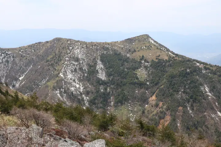
Koeboshi-dake is the 2,042 m south peak of Mount Eboshi (2,066 m) in Tomi in Nagano Prefecture. Climbed from Jizō Pass in the Yunomaru highlands, it is known for azaleas and alpine flowers. An old volcano at the western edge of the Asama range, it lies within the Jōshin'etsu-Kōgen National Park.
Koeboshidake at a glance
- Weather: The most settled day in the next 7 days is Wed, November 4: clear, gusts up to 8 m/s.
- Route: The shortest is Mount Yunomaru and Mount Eboshi Circuit from Jizō Pass: about 5 h 16 min, 9.2 km, about 660 m of climbing.
Koeboshidake weather (hourly, 14 days)
Sunrise today 06:11, sunset 16:49
| Tue, 11/3 | Wed, 11/4 | Thu, 11/5 | Fri, 11/6 | Sat, 11/7 | Sun, 11/8 | Mon, 11/9 | Tue, 11/10 | Wed, 11/11 | Thu, 11/12 | Fri, 11/13 | Sat, 11/14 | Sun, 11/15 | Mon, 11/16 | Tue, 11/17 | |||||||||||||||||||||||||||||||||||||||||||||||||||||||||||||||||||||||
|---|---|---|---|---|---|---|---|---|---|---|---|---|---|---|---|---|---|---|---|---|---|---|---|---|---|---|---|---|---|---|---|---|---|---|---|---|---|---|---|---|---|---|---|---|---|---|---|---|---|---|---|---|---|---|---|---|---|---|---|---|---|---|---|---|---|---|---|---|---|---|---|---|---|---|---|---|---|---|---|---|---|---|---|---|---|
| Japan time | 15 | 17 | 19 | 21 | 23 | 1 | 3 | 5 | 7 | 9 | 11 | 13 | 15 | 18 | 21 | 0 | 3 | 6 | 9 | 12 | 15 | 18 | 21 | 0 | 3 | 6 | 9 | 12 | 15 | 18 | 21 | 0 | 3 | 6 | 9 | 12 | 15 | 18 | 21 | 0 | 3 | 6 | 9 | 12 | 15 | 18 | 21 | 0 | 3 | 6 | 9 | 15 | 21 | 3 | 9 | 15 | 21 | 3 | 9 | 15 | 21 | 3 | 9 | 15 | 21 | 3 | 9 | 15 | 21 | 3 | 9 | 15 | 21 | 3 | 9 | 15 | 21 | 3 | 9 | 15 | 21 | 3 | 9 | 15 | |
  |   | | | | | | |  | | | | |   | |   | | |   | | |   | | | |   | | | | | | | | | | |   | | | | | | | | | | | | | | | | | | | | |   |   |   | | | | | | |   | | |  | | | | | |   | | | | | | | | | ||
| Temperature | °C | 5° | 1° | -2° | -4° | -4° | -4° | -3° | -3° | -2° | 3° | 6° | 8° | 7° | 2° | 2° | 1° | 1° | 2° | 4° | 7° | 8° | 5° | 5° | 4° | 4° | 3° | 7° | 10° | 8° | 4° | 2° | 0° | -2° | -3° | -1° | 0° | 0° | -4° | -6° | -6° | -6° | -7° | -1° | 3° | 1° | -2° | -3° | -3° | -3° | -3° | 0° | 3° | -2° | -3° | 1° | 2° | -3° | -5° | -5° | -3° | -5° | -7° | -1° | 2° | -6° | -4° | -2° | -3° | -7° | -7° | 0° | 5° | -3° | -2° | 3° | 7° | 2° | 3° | 5° | 3° | -3° | -6° | -2° | 2° |
| Precipitation | mm | 0.8 | 10 | 4.0 | 1.5 | 1.0 | 0.2 | 0.2 | 0.5 | 0.8 | 0.2 | 1.5 | 1.8 | 1.4 | 0.1 | 0.1 | 6 | 6 | 0.4 | 0.1 | |||||||||||||||||||||||||||||||||||||||||||||||||||||||||||||||||
| New snow | cm | 0.9 | 1.7 | 1.0 | <.1 | ||||||||||||||||||||||||||||||||||||||||||||||||||||||||||||||||||||||||||||||||
| Snow depth | cm | 0 | 0 | 0 | 0 | 0 | 0 | 0 | 0 | 0 | 0 | 0 | 0 | 0 | 0 | 0 | 0 | 0 | 0 | 0 | 0 | 0 | 0 | 0 | 0 | 0 | 0 | 0 | 0 | 0 | 0 | 0 | 0 | 0 | 0 | 0 | 0 | 0 | 0 | 0 | 0 | 0 | 0 | 0 | 0 | 0 | 0 | 0 | 0 | 0 | 0 | 0 | 0 | 0 | 0 | 0 | 0 | 0 | <1 | 2 | 2 | 1 | 1 | 1 | <1 | <1 | <1 | <1 | 0 | 0 | 0 | 0 | 0 | 0 | 0 | 0 | 0 | 0 | 0 | 0 | 0 | 0 | 0 | 0 | 0 |
| Wind | m/s | 2 | 1 | 1 | 1 | 1 | 1 | 1 | 1 | 0 | 1 | 2 | 2 | 2 | 2 | 3 | 2 | 2 | 1 | 1 | 0 | 0 | 1 | 1 | 0 | 1 | 1 | 2 | 2 | 2 | 2 | 2 | 3 | 3 | 2 | 3 | 3 | 2 | 2 | 1 | 2 | 2 | 2 | 2 | 3 | 3 | 1 | 1 | 1 | 1 | 1 | 0 | 2 | 1 | 1 | 2 | 3 | 2 | 4 | 4 | 5 | 2 | 1 | 1 | 2 | 1 | 2 | 3 | 4 | 2 | 2 | 1 | 1 | 1 | 0 | 1 | 3 | 2 | 1 | 2 | 5 | 4 | 2 | 1 | 2 |
| Wind gusts | m/s | 8 | 8 | 5 | 3 | 3 | 3 | 2 | 2 | 2 | 5 | 6 | 7 | 8 | 8 | 9 | 10 | 8 | 7 | 6 | 5 | 6 | 4 | 4 | 5 | 5 | 5 | 8 | 10 | 10 | 8 | 8 | 9 | 10 | 11 | 11 | 13 | 11 | 9 | 8 | 7 | 8 | 8 | 8 | 10 | 11 | 9 | 4 | 5 | 5 | 5 | 6 | 9 | 7 | 4 | 6 | 10 | 10 | 13 | 19 | 20 | 18 | 9 | 6 | 8 | 7 | 6 | 10 | 14 | 14 | 8 | 6 | 6 | 5 | 4 | 6 | 11 | 10 | 11 | 9 | 17 | 17 | 14 | 7 | 7 |
| Wind dir. | ↓ | ↓ | ↓ | ↓ | ↓ | ↓ | ↓ | ↓ | ↓ | ↓ | ↓ | ↓ | ↓ | ↓ | ↓ | ↓ | ↓ | ↓ | ↓ | ↓ | ↓ | ↓ | ↓ | ↓ | ↓ | ↓ | ↓ | ↓ | ↓ | ↓ | ↓ | ↓ | ↓ | ↓ | ↓ | ↓ | ↓ | ↓ | ↓ | ↓ | ↓ | ↓ | ↓ | ↓ | ↓ | ↓ | ↓ | ↓ | ↓ | ↓ | ↓ | ↓ | ↓ | ↓ | ↓ | ↓ | ↓ | ↓ | ↓ | ↓ | ↓ | ↓ | ↓ | ↓ | ↓ | ↓ | ↓ | ↓ | ↓ | ↓ | ↓ | ↓ | ↓ | ↓ | ↓ | ↓ | ↓ | ↓ | ↓ | ↓ | ↓ | ↓ | ↓ | ↓ | |
Koeboshidake hiking routes
Hiking times are estimates calculated from the terrain.
Huts, campsites and lodging near Koeboshidake
Campsites
- 湯の丸キャンプ場
Lodging
- 紅葉館
Koeboshidake facts
- Elevation
- 2,042 m
- Location
- Tōmi-shi, Nagano
36.429755, 138.388869 - National Park
- 上信越高原国立公園
- Website
- tomikan.jp
- Trail Map
- tomikan.jp (PDF)
- Wikipedia
- ja.wikipedia.org