
Mt. Taisen
大船山
Taketa, Oita · Elevation 1,786 m
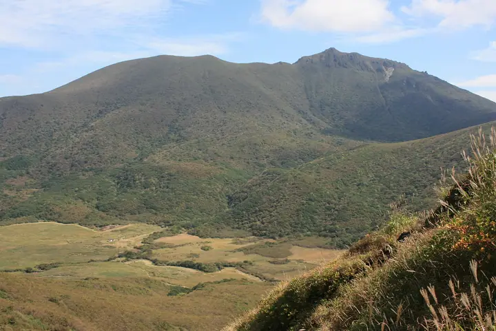
Mt. Taisen (1,786 m) rises in Kuju Town, Taketa City, Ōita, as one of the principal peaks of the eastern Kuju Range within Aso-Kuju National Park. Famed for sweeping displays of Miyamakirishima azaleas and dōdan azaleas, it produces some of Kyūshū's earliest autumn colours, set off by the small crater lake of Ōike just below the summit. A symbol of the Kuju Range alongside Mt. Kuju, it is counted among Japan's 300 Famous Mountains, the 100 Famous Mountains of Kyūshū, and the "Kuju 17 Summits." Trails climb from Bōgatsuru, Imamizu, and other trailheads, and the annual Kuju Mountain Opening ceremony each spring is one of Kyūshū's signature hiking events.
Mt. Taisen at a glance
- Weather: The most settled day in the next 7 days is Sun, November 8: cloudy, gusts up to 6 m/s. Fri, Nov 6: strong wind (gusts up to 17 m/s).
- Route: The shortest is Mount Taisen in Kuju, Return from the Taketa Side via Iriyama Mausoleum and Oike: about 6 h 19 min, 11.8 km, about 1,050 m of climbing.
Mt. Taisen weather (hourly, 14 days)
Sunrise today 06:34, sunset 17:23
| Tue, 11/3 | Wed, 11/4 | Thu, 11/5 | Fri, 11/6 | Sat, 11/7 | Sun, 11/8 | Mon, 11/9 | Tue, 11/10 | Wed, 11/11 | Thu, 11/12 | Fri, 11/13 | Sat, 11/14 | Sun, 11/15 | Mon, 11/16 | Tue, 11/17 | |||||||||||||||||||||||||||||||||||||||||||||||||||||||||||||||||||||||
|---|---|---|---|---|---|---|---|---|---|---|---|---|---|---|---|---|---|---|---|---|---|---|---|---|---|---|---|---|---|---|---|---|---|---|---|---|---|---|---|---|---|---|---|---|---|---|---|---|---|---|---|---|---|---|---|---|---|---|---|---|---|---|---|---|---|---|---|---|---|---|---|---|---|---|---|---|---|---|---|---|---|---|---|---|---|
| Japan time | 15 | 17 | 19 | 21 | 23 | 1 | 3 | 5 | 7 | 9 | 11 | 13 | 15 | 18 | 21 | 0 | 3 | 6 | 9 | 12 | 15 | 18 | 21 | 0 | 3 | 6 | 9 | 12 | 15 | 18 | 21 | 0 | 3 | 6 | 9 | 12 | 15 | 18 | 21 | 0 | 3 | 6 | 9 | 12 | 15 | 18 | 21 | 0 | 3 | 6 | 9 | 15 | 21 | 3 | 9 | 15 | 21 | 3 | 9 | 15 | 21 | 3 | 9 | 15 | 21 | 3 | 9 | 15 | 21 | 3 | 9 | 15 | 21 | 3 | 9 | 15 | 21 | 3 | 9 | 15 | 21 | 3 | 9 | 15 | |
  |   |   |   | | | | |   | | | | |   | | |   |   |  |   | | | | | | | | | |  | | | | | | | | | | | | | | | | | | | | | | | |   | | | | |   | |   | | | |  | | | | | | | | | | | | | | |   | | | | | ||
| Temperature | °C | 8° | 6° | 4° | 4° | 2° | 2° | 3° | 2° | 3° | 5° | 9° | 9° | 10° | 6° | 6° | 6° | 6° | 6° | 9° | 12° | 12° | 10° | 10° | 9° | 7° | 5° | 6° | 9° | 8° | 2° | 0° | -1° | -3° | -4° | 0° | 5° | 5° | 0° | -3° | -3° | -3° | -3° | 3° | 6° | 7° | 3° | 3° | 2° | 4° | 2° | 5° | 7° | 0° | 0° | 3° | 5° | -1° | -1° | 0° | 4° | -3° | -4° | 2° | 7° | -2° | -3° | 4° | 7° | 0° | 1° | 3° | 9° | 3° | 5° | 8° | 9° | 6° | 7° | 7° | 9° | 2° | 3° | 3° | 9° |
| Precipitation | mm | 0.4 | 0.3 | 0.8 | 0.3 | 1.5 | 1.7 | 1.2 | 0.5 | 0.3 | 0.1 | 0.2 | 3.4 | 3.7 | 0.2 | 0.1 | 0.1 | ||||||||||||||||||||||||||||||||||||||||||||||||||||||||||||||||||||
| New snow | cm | ||||||||||||||||||||||||||||||||||||||||||||||||||||||||||||||||||||||||||||||||||||
| Snow depth | cm | 0 | 0 | 0 | 0 | 0 | 0 | 0 | 0 | 0 | 0 | 0 | 0 | 0 | 0 | 0 | 0 | 0 | 0 | 0 | 0 | 0 | 0 | 0 | 0 | 0 | 0 | 0 | 0 | 0 | 0 | 0 | 0 | 0 | 0 | 0 | 0 | 0 | 0 | 0 | 0 | 0 | 0 | 0 | 0 | 0 | 0 | 0 | 0 | 0 | 0 | 0 | 0 | 0 | 0 | 0 | 0 | 0 | 0 | 0 | 0 | 0 | 0 | 0 | 0 | 0 | 0 | 0 | 0 | 0 | 0 | 0 | 0 | 0 | 0 | 0 | 0 | 0 | 0 | 0 | 0 | 0 | 0 | 0 | 0 |
| Wind | m/s | 2 | 2 | 1 | 1 | 1 | 1 | 1 | 1 | 1 | 2 | 3 | 2 | 2 | 2 | 2 | 0 | 0 | 0 | 1 | 2 | 4 | 4 | 5 | 4 | 4 | 4 | 5 | 6 | 5 | 4 | 5 | 4 | 4 | 3 | 3 | 3 | 3 | 2 | 1 | 0 | 0 | 0 | 1 | 1 | 2 | 1 | 0 | 1 | 1 | 1 | 1 | 3 | 2 | 2 | 3 | 5 | 3 | 2 | 3 | 2 | 1 | 1 | 1 | 2 | 2 | 1 | 1 | 2 | 1 | 1 | 1 | 2 | 0 | 1 | 2 | 2 | 2 | 3 | 4 | 4 | 1 | 2 | 1 | 1 |
| Wind gusts | m/s | 7 | 7 | 5 | 4 | 4 | 3 | 3 | 4 | 5 | 6 | 8 | 9 | 7 | 6 | 6 | 6 | 3 | 3 | 5 | 8 | 12 | 13 | 14 | 14 | 13 | 14 | 14 | 17 | 17 | 15 | 15 | 15 | 15 | 14 | 13 | 12 | 10 | 8 | 6 | 3 | 2 | 2 | 4 | 5 | 6 | 6 | 3 | 5 | 6 | 6 | 5 | 9 | 9 | 7 | 10 | 13 | 13 | 11 | 10 | 10 | 8 | 4 | 5 | 7 | 7 | 6 | 5 | 8 | 6 | 4 | 4 | 7 | 6 | 5 | 10 | 12 | 9 | 10 | 12 | 12 | 11 | 5 | 4 | 6 |
| Wind dir. | ↓ | ↓ | ↓ | ↓ | ↓ | ↓ | ↓ | ↓ | ↓ | ↓ | ↓ | ↓ | ↓ | ↓ | ↓ | ↓ | ↓ | ↓ | ↓ | ↓ | ↓ | ↓ | ↓ | ↓ | ↓ | ↓ | ↓ | ↓ | ↓ | ↓ | ↓ | ↓ | ↓ | ↓ | ↓ | ↓ | ↓ | ↓ | ↓ | ↓ | ↓ | ↓ | ↓ | ↓ | ↓ | ↓ | ↓ | ↓ | ↓ | ↓ | ↓ | ↓ | ↓ | ↓ | ↓ | ↓ | ↓ | ↓ | ↓ | ↓ | ↓ | ↓ | ↓ | ↓ | ↓ | ↓ | ↓ | ↓ | ↓ | ↓ | ↓ | ↓ | ↓ | ↓ | ↓ | ↓ | ↓ | ↓ | ↓ | ↓ | ↓ | ↓ | ↓ | ↓ | |
Mt. Taisen hiking routes
- Mount Taisen in Kuju, Return from the Taketa Side via Iriyama Mausoleum and Oike 11.8 km · Ascent 1,047 m
- Mount Taisen Return via Yoshiobu, Bogatsuru and Danbara 13.2 km · Ascent 911 m parking
- Mount Taisen Return from Chojabaru via Amagaike Pass 14.6 km · Ascent 1,009 m 九重登山口 (Bus stop) (parking)
Hiking times are estimates calculated from the terrain.
Huts, campsites and lodging near Mt. Taisen
Mountain huts
- 大船山避難小屋 unstaffed
- 坊ガツル避難小屋 unstaffed
- あせび小屋 reservation required
- Hokkein Onsen Sanso reservation required · sleeps 224
- 池ノ小屋 unstaffed
Campsites
- Bokketsuru Camping Ground
- 沢水キャンプ場
Lodging
- 黒嶽荘
Lists that include Mt. Taisen
Japan's 300 Famous Mountains · Kyushu 100 Famous Mountains · Oita 100 Mountains · Kuju 17 Summits · Elevations of 1003 Mountains of Japan · 1000 Mountains of Japan
Mt. Taisen facts
- Elevation
- 1,786 m
- Location
- Taketa, Oita
33.095047, 131.280677 - National Park
- 阿蘇くじゅう国立公園
- Website
- www.env.go.jp
- Trail Map
- www.city.yufu.oita.jp (PDF)
- Access Information
- oita-osoto.jp
- Wikipedia
- ja.wikipedia.org