
Mount Kujū
中岳
Taketa, Oita · Elevation 1,791 m
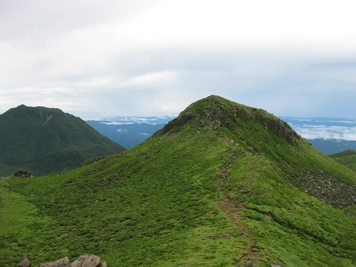
Mount Kujū is a volcanic group spanning Taketa City and Kokonoe Town in Oita Prefecture. Its highest peak, Nakadake in Taketa, rises to 1,791 m and is the highest point on the Kyushu mainland. A prominent mountain area within Aso-Kuju National Park, it includes Kuju, Nakadake, Taisen and Mimata. Dense colonies of Miyama kirishima azaleas, designated a National Natural Monument, turn the upper slopes pink from late May to mid-June. Wetlands such as Bogatsuru, Amagaike and the Ramsar-listed Tadewara are also highlights. Chojabaru Visitor Center serves as a base for routes starting at Makinoto Pass, Yoshibu and Oike.
Mount Kujū at a glance
- Weather: The most settled day in the next 7 days is Sun, November 8: cloudy, gusts up to 6 m/s. Fri, Nov 6: strong wind (gusts up to 17 m/s).
- Route: The shortest is Kuju Nakadake via Tengugajo from Makinoto Pass: about 5 h 45 min, 10.1 km, about 650 m of climbing.
Mount Kujū weather (hourly, 14 days)
Sunrise today 06:34, sunset 17:23
| Tue, 11/3 | Wed, 11/4 | Thu, 11/5 | Fri, 11/6 | Sat, 11/7 | Sun, 11/8 | Mon, 11/9 | Tue, 11/10 | Wed, 11/11 | Thu, 11/12 | Fri, 11/13 | Sat, 11/14 | Sun, 11/15 | Mon, 11/16 | Tue, 11/17 | |||||||||||||||||||||||||||||||||||||||||||||||||||||||||||||||||||||||
|---|---|---|---|---|---|---|---|---|---|---|---|---|---|---|---|---|---|---|---|---|---|---|---|---|---|---|---|---|---|---|---|---|---|---|---|---|---|---|---|---|---|---|---|---|---|---|---|---|---|---|---|---|---|---|---|---|---|---|---|---|---|---|---|---|---|---|---|---|---|---|---|---|---|---|---|---|---|---|---|---|---|---|---|---|---|
| Japan time | 15 | 17 | 19 | 21 | 23 | 1 | 3 | 5 | 7 | 9 | 11 | 13 | 15 | 18 | 21 | 0 | 3 | 6 | 9 | 12 | 15 | 18 | 21 | 0 | 3 | 6 | 9 | 12 | 15 | 18 | 21 | 0 | 3 | 6 | 9 | 12 | 15 | 18 | 21 | 0 | 3 | 6 | 9 | 12 | 15 | 18 | 21 | 0 | 3 | 6 | 9 | 15 | 21 | 3 | 9 | 15 | 21 | 3 | 9 | 15 | 21 | 3 | 9 | 15 | 21 | 3 | 9 | 15 | 21 | 3 | 9 | 15 | 21 | 3 | 9 | 15 | 21 | 3 | 9 | 15 | 21 | 3 | 9 | 15 | |
  |   |   |   | | | | |   | | | | |   | | |   |   |  |   | | | | | | | | | |  | | | | | | | | | | | | | | | | | | | | | | | |   | | | | |   | |   | | | |  | | | | | | | | | | | | | | |   | | | | | ||
| Temperature | °C | 8° | 6° | 4° | 4° | 2° | 2° | 3° | 2° | 3° | 5° | 8° | 9° | 10° | 6° | 6° | 6° | 6° | 6° | 9° | 11° | 12° | 10° | 10° | 9° | 7° | 5° | 6° | 9° | 8° | 2° | 0° | -1° | -3° | -4° | 0° | 5° | 5° | 0° | -3° | -3° | -3° | -3° | 3° | 6° | 7° | 3° | 3° | 2° | 4° | 2° | 4° | 7° | 0° | 0° | 3° | 5° | -1° | -1° | 0° | 4° | -3° | -4° | 2° | 7° | -2° | -3° | 4° | 7° | 0° | 1° | 3° | 9° | 3° | 4° | 8° | 9° | 6° | 7° | 7° | 9° | 2° | 3° | 3° | 9° |
| Precipitation | mm | 0.4 | 0.3 | 0.8 | 0.3 | 1.5 | 1.7 | 1.2 | 0.5 | 0.3 | 0.1 | 0.2 | 3.4 | 3.7 | 0.2 | 0.1 | 0.1 | ||||||||||||||||||||||||||||||||||||||||||||||||||||||||||||||||||||
| New snow | cm | ||||||||||||||||||||||||||||||||||||||||||||||||||||||||||||||||||||||||||||||||||||
| Snow depth | cm | 0 | 0 | 0 | 0 | 0 | 0 | 0 | 0 | 0 | 0 | 0 | 0 | 0 | 0 | 0 | 0 | 0 | 0 | 0 | 0 | 0 | 0 | 0 | 0 | 0 | 0 | 0 | 0 | 0 | 0 | 0 | 0 | 0 | 0 | 0 | 0 | 0 | 0 | 0 | 0 | 0 | 0 | 0 | 0 | 0 | 0 | 0 | 0 | 0 | 0 | 0 | 0 | 0 | 0 | 0 | 0 | 0 | 0 | 0 | 0 | 0 | 0 | 0 | 0 | 0 | 0 | 0 | 0 | 0 | 0 | 0 | 0 | 0 | 0 | 0 | 0 | 0 | 0 | 0 | 0 | 0 | 0 | 0 | 0 |
| Wind | m/s | 2 | 2 | 1 | 1 | 1 | 1 | 1 | 1 | 1 | 2 | 3 | 2 | 2 | 2 | 2 | 0 | 0 | 0 | 1 | 2 | 4 | 4 | 5 | 4 | 4 | 4 | 5 | 6 | 5 | 4 | 5 | 4 | 4 | 3 | 3 | 3 | 3 | 2 | 1 | 0 | 0 | 0 | 1 | 1 | 2 | 1 | 0 | 1 | 1 | 1 | 1 | 3 | 2 | 2 | 3 | 5 | 3 | 2 | 3 | 2 | 1 | 1 | 1 | 2 | 2 | 1 | 1 | 2 | 1 | 1 | 1 | 2 | 0 | 1 | 2 | 2 | 2 | 3 | 4 | 4 | 1 | 2 | 1 | 1 |
| Wind gusts | m/s | 7 | 7 | 5 | 4 | 4 | 3 | 3 | 4 | 5 | 6 | 8 | 9 | 7 | 6 | 6 | 6 | 3 | 3 | 5 | 8 | 12 | 13 | 14 | 14 | 13 | 14 | 14 | 17 | 17 | 15 | 15 | 15 | 15 | 14 | 13 | 12 | 10 | 8 | 6 | 3 | 2 | 2 | 4 | 5 | 6 | 6 | 3 | 5 | 6 | 6 | 5 | 9 | 9 | 7 | 10 | 13 | 13 | 11 | 10 | 10 | 8 | 4 | 5 | 7 | 7 | 6 | 5 | 8 | 6 | 4 | 4 | 7 | 6 | 5 | 10 | 12 | 9 | 10 | 12 | 12 | 11 | 5 | 4 | 6 |
| Wind dir. | ↓ | ↓ | ↓ | ↓ | ↓ | ↓ | ↓ | ↓ | ↓ | ↓ | ↓ | ↓ | ↓ | ↓ | ↓ | ↓ | ↓ | ↓ | ↓ | ↓ | ↓ | ↓ | ↓ | ↓ | ↓ | ↓ | ↓ | ↓ | ↓ | ↓ | ↓ | ↓ | ↓ | ↓ | ↓ | ↓ | ↓ | ↓ | ↓ | ↓ | ↓ | ↓ | ↓ | ↓ | ↓ | ↓ | ↓ | ↓ | ↓ | ↓ | ↓ | ↓ | ↓ | ↓ | ↓ | ↓ | ↓ | ↓ | ↓ | ↓ | ↓ | ↓ | ↓ | ↓ | ↓ | ↓ | ↓ | ↓ | ↓ | ↓ | ↓ | ↓ | ↓ | ↓ | ↓ | ↓ | ↓ | ↓ | ↓ | ↓ | ↓ | ↓ | ↓ | ↓ | |
Mount Kujū live cameras
Mount Kujū hiking routes
- Kuju Nakadake via Tengugajo from Makinoto Pass 10.1 km · Ascent 654 m Makinoto Pass (Bus stop) (parking)
- Tengugajo–Nakadake–Inaboshiyama–Kujusan Circuit from Makinoto Pass 11.4 km · Ascent 854 m Makinoto Pass (Bus stop) (parking)
Hiking times are estimates calculated from the terrain.
Huts, campsites and lodging near Mount Kujū
Mountain huts
- 池ノ小屋 unstaffed
- Kuju Refuge Hut unstaffed
- Hokkein Onsen Sanso reservation required · sleeps 224
- スガモリ小屋跡
- あせび小屋 reservation required
Campsites
- Bokketsuru Camping Ground
- 沢水キャンプ場
- 久住山荘南登山口キャンプ場
- くじゅうやまなみキャンプ村
Lodging
- Kan-no-jigoku Ryokan
- 九重観光ホテル
- Hanasansui
- オーベルジュ・コスモス
Lists that include Mount Kujū
100 Famous Japanese Mountains · Japan 200 Famous Mountains · Japan's 300 Famous Mountains · 100 Famous Mountains of Flowers · Highest Peaks by Prefecture · 100 Famous Hot Spring Mountains · Oita 100 Mountains · Kuju 17 Summits · Elevations of 1003 Mountains of Japan
Mount Kujū facts
- Also known as
- くじゅう連山 · Kujū Mountains
- Elevation
- 1,791 m
- Location
- Taketa, Oita
33.085995, 131.249070 - National Park
- 阿蘇くじゅう国立公園
- Volcano
- Active volcano (九重山)
- Website
- www.visit-oita.jp
- Trail Map
- www.city.taketa.oita.jp (PDF)
- Wikipedia
- ja.wikipedia.org