
Mt. Sanpouiwadake
三方岩岳
Shirakawa, Gifu · Elevation 1,736 m
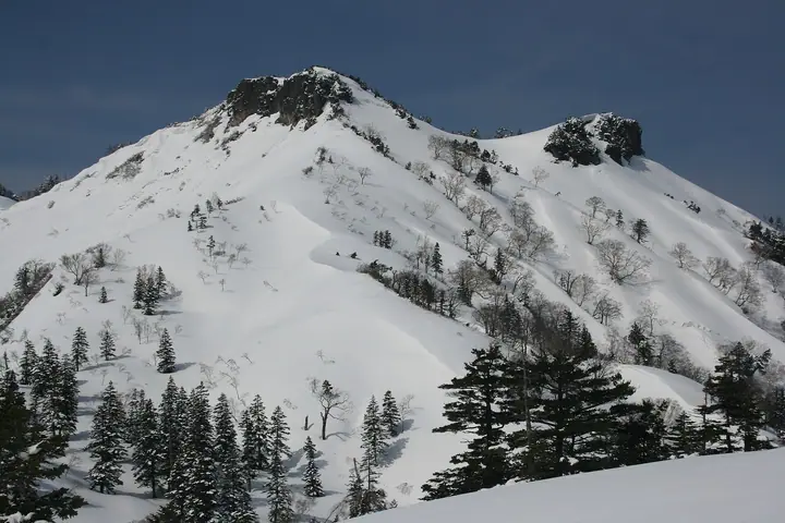
Mt. Sanpouiwadake (1,736 m) straddles the Ishikawa–Gifu prefectural border between Hakusan City and Shirakawa Village, in the northern Ryohaku range within Hakusan National Park. Its name comes from three great rock faces — Hida-iwa, Etchu-iwa and Kaga-iwa — that drop from the summit ridge, and the observation point commands sweeping views of the Hakusan range and the Northern Alps. The peak is listed in Japan's 300 Famous Mountains and the 100 Mountains of Gifu. From the Sanpoiwa parking area on the Hakusan Shirakawa-go White Road, the standard route reaches the summit in about 50 minutes, making it one of the more accessible 1,700 m peaks in the area.
Mt. Sanpouiwadake at a glance
- Weather: The most settled day in the next 7 days is Wed, November 4: clear, gusts up to 6 m/s.
- Route: The shortest is Mount Sanpoiwa–Mount Nodanisoji Ridge Hike: about 4 h 42 min, 7.4 km, about 680 m of climbing.
Mt. Sanpouiwadake weather (hourly, 14 days)
Sunrise today 06:17, sunset 16:56
| Tue, 11/3 | Wed, 11/4 | Thu, 11/5 | Fri, 11/6 | Sat, 11/7 | Sun, 11/8 | Mon, 11/9 | Tue, 11/10 | Wed, 11/11 | Thu, 11/12 | Fri, 11/13 | Sat, 11/14 | Sun, 11/15 | Mon, 11/16 | Tue, 11/17 | |||||||||||||||||||||||||||||||||||||||||||||||||||||||||||||||||||||||
|---|---|---|---|---|---|---|---|---|---|---|---|---|---|---|---|---|---|---|---|---|---|---|---|---|---|---|---|---|---|---|---|---|---|---|---|---|---|---|---|---|---|---|---|---|---|---|---|---|---|---|---|---|---|---|---|---|---|---|---|---|---|---|---|---|---|---|---|---|---|---|---|---|---|---|---|---|---|---|---|---|---|---|---|---|---|
| Japan time | 15 | 17 | 19 | 21 | 23 | 1 | 3 | 5 | 7 | 9 | 11 | 13 | 15 | 18 | 21 | 0 | 3 | 6 | 9 | 12 | 15 | 18 | 21 | 0 | 3 | 6 | 9 | 12 | 15 | 18 | 21 | 0 | 3 | 6 | 9 | 12 | 15 | 18 | 21 | 0 | 3 | 6 | 9 | 12 | 15 | 18 | 21 | 0 | 3 | 6 | 9 | 15 | 21 | 3 | 9 | 15 | 21 | 3 | 9 | 15 | 21 | 3 | 9 | 15 | 21 | 3 | 9 | 15 | 21 | 3 | 9 | 15 | 21 | 3 | 9 | 15 | 21 | 3 | 9 | 15 | 21 | 3 | 9 | 15 | |
  |   |  | | | | | | |  | | |   |   | |   | | |   |   | | | | | | |   | | | | | |   | |   | |   | | |   | |   | | | | | | | | | | | | | |   | | | | |   |  | | | | | | | | | | | | | | | | | | | | | | | ||
| Temperature | °C | 5° | 1° | -1° | -2° | -3° | -2° | -2° | -3° | -3° | 4° | 9° | 10° | 9° | 5° | 5° | 4° | 4° | 5° | 6° | 9° | 10° | 6° | 6° | 4° | 4° | 5° | 5° | 7° | 4° | 2° | 0° | -1° | -3° | -3° | -4° | -3° | -3° | -5° | -4° | -5° | -5° | -5° | -1° | 2° | 0° | -2° | -2° | -2° | -2° | -2° | 2° | 2° | -2° | -4° | 2° | 4° | -1° | -6° | -4° | -3° | -5° | -7° | -1° | 1° | -4° | -2° | -2° | -1° | -6° | -6° | 2° | 6° | -1° | -1° | 3° | 4° | 4° | 4° | 4° | 1° | -3° | -4° | -1° | 3° |
| Precipitation | mm | 0.9 | 5 | 4.1 | 3.8 | 0.2 | 1.0 | 1.2 | 0.3 | 5 | 2.3 | 1.2 | 1.0 | 1.5 | 1.4 | 1.0 | 1.2 | 1.3 | 2.2 | 2.3 | 2.0 | 1.1 | 0.5 | 0.5 | 0.2 | 0.1 | 0.7 | 0.9 | 0.8 | 0.1 | 7 | 9 | 1.9 | 1.7 | 0.2 | 1.5 | 4.6 | 0.1 | 1.2 | 6 | 6 | 5 | 8 | 1.5 | |||||||||||||||||||||||||||||||||||||||||
| New snow | cm | 0.3 | 1.4 | 1.9 | 1.8 | 0.8 | 0.4 | 0.3 | 0.2 | <.1 | <.1 | 7.0 | 1.9 | 1.4 | <.1 | ||||||||||||||||||||||||||||||||||||||||||||||||||||||||||||||||||||||
| Snow depth | cm | 0 | 0 | 0 | 0 | 0 | 0 | 0 | 0 | 0 | 0 | 0 | 0 | 0 | 0 | 0 | 0 | 0 | 0 | 0 | 0 | 0 | 0 | 0 | 0 | 0 | 0 | 0 | 0 | 0 | 0 | 0 | 0 | 0 | 1 | 2 | 3 | 3 | 3 | 3 | 3 | 3 | 3 | 3 | 2 | 2 | 2 | 2 | 2 | 1 | 1 | 1 | <1 | 0 | 0 | 0 | 0 | 0 | 4 | 6 | 5 | 5 | 5 | 5 | 3 | 3 | 3 | 2 | 2 | 1 | 1 | 1 | <1 | <1 | <1 | <1 | 0 | 0 | 0 | 0 | 0 | 0 | 0 | 0 | 0 |
| Wind | m/s | 2 | 1 | 1 | 1 | 1 | 0 | 0 | 0 | 1 | 1 | 1 | 1 | 1 | 1 | 1 | 0 | 1 | 1 | 1 | 1 | 1 | 0 | 1 | 1 | 1 | 2 | 2 | 4 | 3 | 2 | 3 | 3 | 2 | 3 | 3 | 3 | 3 | 3 | 3 | 2 | 2 | 1 | 1 | 3 | 2 | 0 | 1 | 0 | 1 | 1 | 2 | 1 | 0 | 1 | 2 | 3 | 2 | 5 | 5 | 4 | 1 | 1 | 0 | 2 | 1 | 1 | 3 | 4 | 0 | 0 | 1 | 1 | 1 | 2 | 3 | 2 | 2 | 1 | 3 | 4 | 2 | 1 | 1 | 1 |
| Wind gusts | m/s | 9 | 7 | 4 | 4 | 4 | 4 | 3 | 3 | 3 | 5 | 5 | 6 | 6 | 6 | 7 | 7 | 7 | 8 | 6 | 6 | 6 | 5 | 4 | 6 | 8 | 8 | 9 | 13 | 14 | 12 | 12 | 13 | 13 | 12 | 11 | 12 | 12 | 11 | 10 | 10 | 8 | 8 | 6 | 9 | 9 | 6 | 4 | 4 | 5 | 5 | 7 | 10 | 6 | 4 | 8 | 12 | 11 | 17 | 18 | 16 | 14 | 6 | 4 | 8 | 8 | 6 | 11 | 12 | 12 | 6 | 5 | 6 | 5 | 6 | 11 | 13 | 12 | 14 | 9 | 14 | 15 | 8 | 5 | 6 |
| Wind dir. | ↓ | ↓ | ↓ | ↓ | ↓ | ↓ | ↓ | ↓ | ↓ | ↓ | ↓ | ↓ | ↓ | ↓ | ↓ | ↓ | ↓ | ↓ | ↓ | ↓ | ↓ | ↓ | ↓ | ↓ | ↓ | ↓ | ↓ | ↓ | ↓ | ↓ | ↓ | ↓ | ↓ | ↓ | ↓ | ↓ | ↓ | ↓ | ↓ | ↓ | ↓ | ↓ | ↓ | ↓ | ↓ | ↓ | ↓ | ↓ | ↓ | ↓ | ↓ | ↓ | ↓ | ↓ | ↓ | ↓ | ↓ | ↓ | ↓ | ↓ | ↓ | ↓ | ↓ | ↓ | ↓ | ↓ | ↓ | ↓ | ↓ | ↓ | ↓ | ↓ | ↓ | ↓ | ↓ | ↓ | ↓ | ↓ | ↓ | ↓ | ↓ | ↓ | ↓ | ↓ | |
Mt. Sanpouiwadake hiking routes
Hiking times are estimates calculated from the terrain.
Huts, campsites and lodging near Mt. Sanpouiwadake
Lodging
- トヨタ白川郷自然學校
Lists that include Mt. Sanpouiwadake
Japan's 300 Famous Mountains · 100 Mountains of Hokuriku · 100 Mountains of Gifu · Elevations of 1003 Mountains of Japan
Mt. Sanpouiwadake facts
- Elevation
- 1,736 m
- Location
- Shirakawa, Gifu
36.258181, 136.844544 - National Park
- 白山国立公園
- Website
- hs-whiteroad.jp
- Trail Map
- www.pref.ishikawa.lg.jp (PDF)
- Access Information
- hs-whiteroad.jp
- Wikipedia
- ja.wikipedia.org