
Mt. Sarugabanbayama
猿ヶ馬場山
Shirakawa, Gifu · Elevation 1,875 m
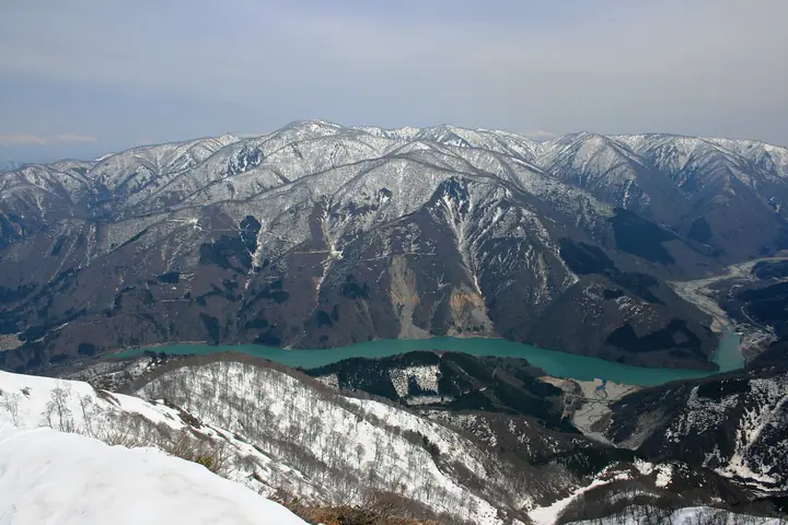
Sarugabanbayama is the 1,875 m highest peak of the Hida Highlands, located in Shirakawa Village, Ōno District, Gifu Prefecture, just east of the UNESCO World Heritage gassho-zukuri village of Shirakawa-gō. The mountain has no maintained hiking trail and is normally climbed only in late winter or early spring during the remaining-snow season. Its northern slopes encompass the Amō Wetland, designated together with the surrounding area as Amō Prefectural Natural Park. It is listed among the Japanese 300 Famous Mountains and the Hundred Mountains of Gifu.
Mt. Sarugabanbayama at a glance
- Weather: The most settled day in the next 7 days is Wed, November 4: clear, gusts up to 8 m/s.
Mt. Sarugabanbayama weather (hourly, 14 days)
Sunrise today 06:16, sunset 16:55
| Tue, 11/3 | Wed, 11/4 | Thu, 11/5 | Fri, 11/6 | Sat, 11/7 | Sun, 11/8 | Mon, 11/9 | Tue, 11/10 | Wed, 11/11 | Thu, 11/12 | Fri, 11/13 | Sat, 11/14 | Sun, 11/15 | Mon, 11/16 | Tue, 11/17 | |||||||||||||||||||||||||||||||||||||||||||||||||||||||||||||||||||||||
|---|---|---|---|---|---|---|---|---|---|---|---|---|---|---|---|---|---|---|---|---|---|---|---|---|---|---|---|---|---|---|---|---|---|---|---|---|---|---|---|---|---|---|---|---|---|---|---|---|---|---|---|---|---|---|---|---|---|---|---|---|---|---|---|---|---|---|---|---|---|---|---|---|---|---|---|---|---|---|---|---|---|---|---|---|---|
| Japan time | 15 | 17 | 19 | 21 | 23 | 1 | 3 | 5 | 7 | 9 | 11 | 13 | 15 | 18 | 21 | 0 | 3 | 6 | 9 | 12 | 15 | 18 | 21 | 0 | 3 | 6 | 9 | 12 | 15 | 18 | 21 | 0 | 3 | 6 | 9 | 12 | 15 | 18 | 21 | 0 | 3 | 6 | 9 | 12 | 15 | 18 | 21 | 0 | 3 | 6 | 9 | 15 | 21 | 3 | 9 | 15 | 21 | 3 | 9 | 15 | 21 | 3 | 9 | 15 | 21 | 3 | 9 | 15 | 21 | 3 | 9 | 15 | 21 | 3 | 9 | 15 | 21 | 3 | 9 | 15 | 21 | 3 | 9 | 15 | |
  |   |  | | | | | | |  | | |   |   | |   | | |   |   | | |   | | | |   | | | | | | |   |   | | | | |   | |   | | | | | | | | | | | | | | | | |   | | | | | | | | | | |  | | | | |   | | | | | | | | | | ||
| Temperature | °C | 7° | 2° | -1° | -2° | -3° | -2° | -2° | -3° | -4° | 4° | 9° | 11° | 10° | 5° | 5° | 4° | 4° | 5° | 5° | 9° | 11° | 7° | 6° | 4° | 5° | 5° | 6° | 9° | 6° | 3° | 1° | 0° | -2° | -2° | -3° | -2° | -2° | -3° | -3° | -4° | -4° | -4° | 0° | 3° | 1° | -1° | -1° | -1° | -1° | 0° | 4° | 3° | -1° | -3° | 3° | 5° | 0° | -5° | -3° | -2° | -4° | -6° | -1° | 3° | -5° | -1° | -1° | 0° | -5° | -6° | 1° | 7° | 0° | 0° | 4° | 5° | 4° | 4° | 5° | 2° | -2° | -4° | -2° | 4° |
| Precipitation | mm | 1.2 | 6 | 3.9 | 4.2 | 0.4 | 0.2 | 1.5 | 0.9 | 3.8 | 1.2 | 0.5 | 0.7 | 0.5 | 0.6 | 0.5 | 0.6 | 0.7 | 1.5 | 2.0 | 1.7 | 0.8 | 0.5 | 0.3 | 0.1 | 0.7 | 0.9 | 0.7 | 0.2 | 4.0 | 7 | 1.5 | 1.4 | 0.2 | 0.6 | 3.9 | 0.2 | 0.7 | 6 | 6 | 3.5 | 5 | 1.1 | 0.1 | |||||||||||||||||||||||||||||||||||||||||
| New snow | cm | 0.2 | 1.0 | 1.0 | 0.3 | <.1 | <.1 | <.1 | 3.6 | 1.5 | 0.6 | ||||||||||||||||||||||||||||||||||||||||||||||||||||||||||||||||||||||||||
| Snow depth | cm | 0 | 0 | 0 | 0 | 0 | 0 | 0 | 0 | 0 | 0 | 0 | 0 | 0 | 0 | 0 | 0 | 0 | 0 | 0 | 0 | 0 | 0 | 0 | 0 | 0 | 0 | 0 | 0 | 0 | 0 | 0 | 0 | 0 | 0 | <1 | <1 | <1 | <1 | <1 | <1 | <1 | <1 | <1 | <1 | 0 | 0 | 0 | 0 | 0 | 0 | 0 | 0 | 0 | 0 | 0 | 0 | 0 | 2 | 3 | 2 | <1 | <1 | <1 | <1 | <1 | <1 | 0 | 0 | 0 | 0 | 0 | 0 | 0 | 0 | 0 | 0 | 0 | 0 | 0 | 0 | 0 | 0 | 0 | 0 |
| Wind | m/s | 2 | 1 | 1 | 1 | 1 | 1 | 1 | 1 | 1 | 1 | 1 | 2 | 2 | 1 | 1 | 0 | 1 | 1 | 1 | 1 | 1 | 0 | 1 | 1 | 1 | 1 | 1 | 4 | 3 | 2 | 3 | 3 | 2 | 2 | 2 | 3 | 3 | 3 | 3 | 2 | 2 | 2 | 2 | 3 | 2 | 1 | 0 | 0 | 0 | 0 | 1 | 2 | 2 | 1 | 3 | 3 | 1 | 4 | 5 | 4 | 2 | 1 | 0 | 3 | 1 | 1 | 3 | 4 | 1 | 0 | 2 | 1 | 1 | 2 | 4 | 2 | 2 | 1 | 2 | 4 | 3 | 1 | 1 | 1 |
| Wind gusts | m/s | 10 | 8 | 6 | 5 | 5 | 5 | 4 | 4 | 3 | 4 | 5 | 8 | 8 | 8 | 8 | 8 | 6 | 7 | 5 | 7 | 5 | 4 | 4 | 5 | 7 | 7 | 7 | 12 | 13 | 11 | 11 | 11 | 12 | 11 | 11 | 12 | 13 | 11 | 11 | 11 | 10 | 9 | 8 | 11 | 11 | 8 | 4 | 4 | 4 | 4 | 4 | 9 | 7 | 6 | 9 | 12 | 10 | 17 | 19 | 19 | 14 | 8 | 4 | 10 | 10 | 6 | 12 | 14 | 14 | 7 | 6 | 6 | 6 | 7 | 13 | 14 | 12 | 12 | 9 | 16 | 15 | 10 | 5 | 5 |
| Wind dir. | ↓ | ↓ | ↓ | ↓ | ↓ | ↓ | ↓ | ↓ | ↓ | ↓ | ↓ | ↓ | ↓ | ↓ | ↓ | ↓ | ↓ | ↓ | ↓ | ↓ | ↓ | ↓ | ↓ | ↓ | ↓ | ↓ | ↓ | ↓ | ↓ | ↓ | ↓ | ↓ | ↓ | ↓ | ↓ | ↓ | ↓ | ↓ | ↓ | ↓ | ↓ | ↓ | ↓ | ↓ | ↓ | ↓ | ↓ | ↓ | ↓ | ↓ | ↓ | ↓ | ↓ | ↓ | ↓ | ↓ | ↓ | ↓ | ↓ | ↓ | ↓ | ↓ | ↓ | ↓ | ↓ | ↓ | ↓ | ↓ | ↓ | ↓ | ↓ | ↓ | ↓ | ↓ | ↓ | ↓ | ↓ | ↓ | ↓ | ↓ | ↓ | ↓ | ↓ | ↓ | |
Huts, campsites and lodging near Mt. Sarugabanbayama
Mountain huts
- kidoya mins huma
Lodging
- Hisamatsu farm
- Juemon
- Koemon
- 民宿 一茶
- Rihei Minshuku
Lists that include Mt. Sarugabanbayama
Japan's 300 Famous Mountains · 100 Mountains of Gifu · Elevations of 1003 Mountains of Japan · 1000 Mountains of Japan
Mt. Sarugabanbayama facts
- Elevation
- 1,875 m
- Location
- Shirakawa, Gifu
36.225944, 136.942901 - Wikipedia
- ja.wikipedia.org