
Mt. Mominukayama
籾糠山
Hida, Gifu · Elevation 1,744 m
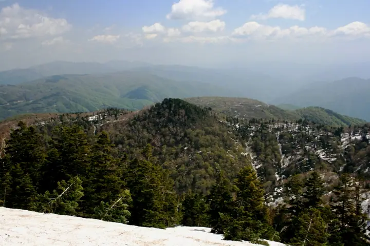
Mt. Mominukayama is a 1,744-meter peak straddling Kawai-chō of Hida City and Shirakawa Village of Ōno District in northern Gifu Prefecture's Hida Highlands. Its surroundings were designated as Amō Prefectural Natural Park in 1998, and a Chūbu-Hokuriku Nature Trail leads from Amō Pass on National Route 360 through old-growth beech and katsura forest and the high-altitude Amō and Kibira wetlands to the summit. Renowned for over 200 plant species — including skunk cabbage and day-lilies — the mountain is listed in the Gifu Hyakuzan, Tōkai-no-Hyakuzan, Hida Hyakuzan, and Gifu Hyakushūzan compilations. The Amō Pass road is typically closed for winter from early November to late May, restricting the climbing season to early summer through late autumn.
Mt. Mominukayama at a glance
- Weather: The most settled day in the next 7 days is Wed, November 4: clear, gusts up to 8 m/s.
Mt. Mominukayama weather (hourly, 14 days)
Sunrise today 06:16, sunset 16:55
| Tue, 11/3 | Wed, 11/4 | Thu, 11/5 | Fri, 11/6 | Sat, 11/7 | Sun, 11/8 | Mon, 11/9 | Tue, 11/10 | Wed, 11/11 | Thu, 11/12 | Fri, 11/13 | Sat, 11/14 | Sun, 11/15 | Mon, 11/16 | Tue, 11/17 | |||||||||||||||||||||||||||||||||||||||||||||||||||||||||||||||||||||||
|---|---|---|---|---|---|---|---|---|---|---|---|---|---|---|---|---|---|---|---|---|---|---|---|---|---|---|---|---|---|---|---|---|---|---|---|---|---|---|---|---|---|---|---|---|---|---|---|---|---|---|---|---|---|---|---|---|---|---|---|---|---|---|---|---|---|---|---|---|---|---|---|---|---|---|---|---|---|---|---|---|---|---|---|---|---|
| Japan time | 15 | 17 | 19 | 21 | 23 | 1 | 3 | 5 | 7 | 9 | 11 | 13 | 15 | 18 | 21 | 0 | 3 | 6 | 9 | 12 | 15 | 18 | 21 | 0 | 3 | 6 | 9 | 12 | 15 | 18 | 21 | 0 | 3 | 6 | 9 | 12 | 15 | 18 | 21 | 0 | 3 | 6 | 9 | 12 | 15 | 18 | 21 | 0 | 3 | 6 | 9 | 15 | 21 | 3 | 9 | 15 | 21 | 3 | 9 | 15 | 21 | 3 | 9 | 15 | 21 | 3 | 9 | 15 | 21 | 3 | 9 | 15 | 21 | 3 | 9 | 15 | 21 | 3 | 9 | 15 | 21 | 3 | 9 | 15 | |
  |   |  | | | | | | |  | | |   |   | |   | | |   |   | | |   | | | |   | | | | | | |   |   | | | | |   | |   | | | | | | | | | | | | | | | | |   | | | | | | | | | | |  | | | | |   | | | | | | | | | | ||
| Temperature | °C | 7° | 3° | 0° | -1° | -2° | -1° | -1° | -2° | -3° | 4° | 9° | 12° | 11° | 6° | 6° | 5° | 5° | 6° | 6° | 9° | 12° | 8° | 7° | 5° | 6° | 6° | 7° | 10° | 7° | 4° | 2° | 1° | -1° | -1° | -2° | -1° | -1° | -3° | -2° | -3° | -3° | -3° | 1° | 4° | 2° | 0° | 0° | 0° | 0° | 1° | 4° | 4° | 0° | -2° | 4° | 6° | 1° | -4° | -2° | -1° | -3° | -5° | 0° | 4° | -4° | -1° | -1° | 1° | -4° | -5° | 2° | 8° | 1° | 1° | 5° | 5° | 5° | 5° | 6° | 3° | -1° | -3° | -1° | 5° |
| Precipitation | mm | 1.2 | 6 | 3.9 | 4.2 | 0.4 | 0.2 | 1.5 | 0.9 | 3.8 | 1.2 | 0.5 | 0.7 | 0.5 | 0.6 | 0.5 | 0.6 | 0.7 | 1.5 | 2.0 | 1.7 | 0.8 | 0.5 | 0.3 | 0.1 | 0.7 | 0.9 | 0.7 | 0.2 | 4.0 | 7 | 1.5 | 1.4 | 0.2 | 0.6 | 3.9 | 0.2 | 0.7 | 6 | 6 | 3.5 | 5 | 1.1 | 0.1 | |||||||||||||||||||||||||||||||||||||||||
| New snow | cm | 0.2 | 1.0 | 1.0 | 0.3 | <.1 | <.1 | <.1 | 3.6 | 1.5 | 0.6 | ||||||||||||||||||||||||||||||||||||||||||||||||||||||||||||||||||||||||||
| Snow depth | cm | 0 | 0 | 0 | 0 | 0 | 0 | 0 | 0 | 0 | 0 | 0 | 0 | 0 | 0 | 0 | 0 | 0 | 0 | 0 | 0 | 0 | 0 | 0 | 0 | 0 | 0 | 0 | 0 | 0 | 0 | 0 | 0 | 0 | 0 | <1 | <1 | <1 | <1 | <1 | <1 | <1 | <1 | <1 | <1 | 0 | 0 | 0 | 0 | 0 | 0 | 0 | 0 | 0 | 0 | 0 | 0 | 0 | 2 | 3 | 2 | <1 | <1 | <1 | <1 | <1 | <1 | 0 | 0 | 0 | 0 | 0 | 0 | 0 | 0 | 0 | 0 | 0 | 0 | 0 | 0 | 0 | 0 | 0 | 0 |
| Wind | m/s | 2 | 1 | 1 | 1 | 1 | 1 | 1 | 1 | 1 | 1 | 1 | 2 | 2 | 1 | 1 | 0 | 1 | 1 | 1 | 1 | 1 | 0 | 1 | 1 | 1 | 1 | 1 | 4 | 3 | 2 | 3 | 3 | 2 | 2 | 2 | 3 | 3 | 3 | 3 | 2 | 2 | 2 | 2 | 3 | 2 | 1 | 0 | 0 | 0 | 0 | 1 | 2 | 2 | 1 | 3 | 3 | 1 | 4 | 5 | 4 | 2 | 1 | 0 | 3 | 1 | 1 | 3 | 4 | 1 | 0 | 2 | 1 | 1 | 2 | 4 | 2 | 2 | 1 | 2 | 4 | 3 | 1 | 1 | 1 |
| Wind gusts | m/s | 10 | 8 | 6 | 5 | 5 | 5 | 4 | 4 | 3 | 4 | 5 | 8 | 8 | 8 | 8 | 8 | 6 | 7 | 5 | 7 | 5 | 4 | 4 | 5 | 7 | 7 | 7 | 12 | 13 | 11 | 11 | 11 | 12 | 11 | 11 | 12 | 13 | 11 | 11 | 11 | 10 | 9 | 8 | 11 | 11 | 8 | 4 | 4 | 4 | 4 | 4 | 9 | 7 | 6 | 9 | 12 | 10 | 17 | 19 | 19 | 14 | 8 | 4 | 10 | 10 | 6 | 12 | 14 | 14 | 7 | 6 | 6 | 6 | 7 | 13 | 14 | 12 | 12 | 9 | 16 | 15 | 10 | 5 | 5 |
| Wind dir. | ↓ | ↓ | ↓ | ↓ | ↓ | ↓ | ↓ | ↓ | ↓ | ↓ | ↓ | ↓ | ↓ | ↓ | ↓ | ↓ | ↓ | ↓ | ↓ | ↓ | ↓ | ↓ | ↓ | ↓ | ↓ | ↓ | ↓ | ↓ | ↓ | ↓ | ↓ | ↓ | ↓ | ↓ | ↓ | ↓ | ↓ | ↓ | ↓ | ↓ | ↓ | ↓ | ↓ | ↓ | ↓ | ↓ | ↓ | ↓ | ↓ | ↓ | ↓ | ↓ | ↓ | ↓ | ↓ | ↓ | ↓ | ↓ | ↓ | ↓ | ↓ | ↓ | ↓ | ↓ | ↓ | ↓ | ↓ | ↓ | ↓ | ↓ | ↓ | ↓ | ↓ | ↓ | ↓ | ↓ | ↓ | ↓ | ↓ | ↓ | ↓ | ↓ | ↓ | ↓ | |
Huts, campsites and lodging near Mt. Mominukayama
Mountain huts
- kidoya mins huma
Lodging
- Hisamatsu farm
- Juemon
- Koemon
- Rihei Minshuku
- 民宿 一茶
Lists that include Mt. Mominukayama
Mt. Mominukayama facts
- Elevation
- 1,744 m
- Location
- Hida, Gifu
36.234326, 136.953362 - Website
- www.hida-kankou.jp
- Trail Map
- www.hida-kankou.jp (PDF)
- Wikipedia
- ja.wikipedia.org