
Mount Ōgasa
大笠山
Nanto, Toyama · Elevation 1,822 m
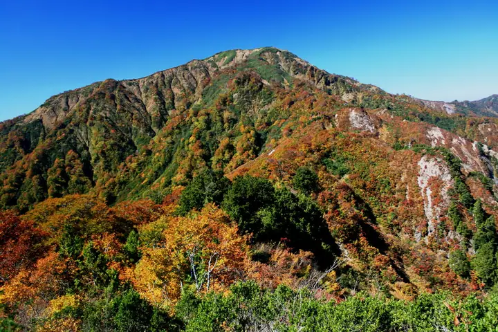
An 1,822 m peak in the northern section of the main ridge of the Ryōhaku Mountains, straddling Nanto City in Toyama Prefecture and Hakusan City in Ishikawa Prefecture. The mountain lies within Hakusan National Park, with its southern slope designated a Special Protection Zone and the northern slope a Special Zone. Selected for the Japan 300 Famous Mountains and the First-Class Triangulation Point 100 Mountains, it is most commonly climbed via the Fukabara ridge from Lake Katsura, though the Nanto City Tourism Association warns that the trail is currently in poor condition.
Mount Ōgasa at a glance
- Weather: The most settled day in the next 7 days is Wed, November 4: clear, gusts up to 8 m/s. Fri, Nov 6: strong wind (gusts up to 16 m/s).
Mount Ōgasa weather (hourly, 14 days)
Sunrise today 06:17, sunset 16:56
| Tue, 11/3 | Wed, 11/4 | Thu, 11/5 | Fri, 11/6 | Sat, 11/7 | Sun, 11/8 | Mon, 11/9 | Tue, 11/10 | Wed, 11/11 | Thu, 11/12 | Fri, 11/13 | Sat, 11/14 | Sun, 11/15 | Mon, 11/16 | Tue, 11/17 | |||||||||||||||||||||||||||||||||||||||||||||||||||||||||||||||||||||||
|---|---|---|---|---|---|---|---|---|---|---|---|---|---|---|---|---|---|---|---|---|---|---|---|---|---|---|---|---|---|---|---|---|---|---|---|---|---|---|---|---|---|---|---|---|---|---|---|---|---|---|---|---|---|---|---|---|---|---|---|---|---|---|---|---|---|---|---|---|---|---|---|---|---|---|---|---|---|---|---|---|---|---|---|---|---|
| Japan time | 15 | 17 | 19 | 21 | 23 | 1 | 3 | 5 | 7 | 9 | 11 | 13 | 15 | 18 | 21 | 0 | 3 | 6 | 9 | 12 | 15 | 18 | 21 | 0 | 3 | 6 | 9 | 12 | 15 | 18 | 21 | 0 | 3 | 6 | 9 | 12 | 15 | 18 | 21 | 0 | 3 | 6 | 9 | 12 | 15 | 18 | 21 | 0 | 3 | 6 | 9 | 15 | 21 | 3 | 9 | 15 | 21 | 3 | 9 | 15 | 21 | 3 | 9 | 15 | 21 | 3 | 9 | 15 | 21 | 3 | 9 | 15 | 21 | 3 | 9 | 15 | 21 | 3 | 9 | 15 | 21 | 3 | 9 | 15 | |
  |  | | |   | | | | |  | | |   |   | |   | | |   | | |   | | | | |   | | | | | | | | |   | | | | |   | | | | | | | | | | | | | | |   | |   |   | | | | | | | | | | |  | | | | | | | | | | | | | | | ||
| Temperature | °C | 6° | 2° | 0° | -1° | -2° | -2° | -2° | -2° | -2° | 6° | 9° | 9° | 8° | 4° | 5° | 4° | 4° | 4° | 6° | 11° | 11° | 7° | 7° | 5° | 5° | 6° | 6° | 8° | 4° | 2° | 1° | 0° | -1° | -2° | -2° | -1° | -1° | -2° | -2° | -3° | -3° | -3° | 1° | 3° | 1° | 0° | -1° | -1° | -1° | 0° | 4° | 2° | 0° | -2° | 4° | 5° | 0° | -4° | -3° | 0° | -3° | -7° | 1° | 2° | -1° | 0° | -1° | 2° | -4° | -5° | 4° | 5° | -2° | 0° | 7° | 6° | 6° | 8° | 5° | 2° | -2° | -3° | 0° | 2° |
| Precipitation | mm | 1.2 | 5 | 2.6 | 3.4 | 1.0 | 2.0 | 0.1 | 7 | 2.3 | 2.4 | 2.2 | 2.9 | 1.2 | 1.7 | 2.4 | 2.0 | 3.0 | 3.5 | 2.7 | 1.4 | 0.8 | 0.6 | 0.1 | 0.1 | 0.5 | 0.4 | 2.0 | 0.3 | 8 | 10 | 2.0 | 1.5 | 1.8 | 5 | 0.1 | 0.9 | 5 | 2.4 | 10 | 10 | 1.4 | 0.1 | ||||||||||||||||||||||||||||||||||||||||||
| New snow | cm | <.1 | 2.6 | 1.2 | 0.2 | ||||||||||||||||||||||||||||||||||||||||||||||||||||||||||||||||||||||||||||||||
| Snow depth | cm | 0 | 0 | 0 | 0 | 0 | 0 | 0 | 0 | 0 | 0 | 0 | 0 | 0 | 0 | 0 | 0 | 0 | 0 | 0 | 0 | 0 | 0 | 0 | 0 | 0 | 0 | 0 | 0 | 0 | 0 | 0 | 0 | 0 | 0 | 0 | 0 | 0 | 0 | 0 | 0 | 0 | 0 | 0 | 0 | 0 | 0 | 0 | 0 | 0 | 0 | 0 | 0 | 0 | 0 | 0 | 0 | 0 | 1 | 2 | <1 | <1 | <1 | <1 | <1 | 0 | 0 | 0 | 0 | 0 | 0 | 0 | 0 | 0 | 0 | 0 | 0 | 0 | 0 | 0 | 0 | 0 | 0 | 0 | 0 |
| Wind | m/s | 2 | 1 | 1 | 1 | 1 | 2 | 2 | 2 | 3 | 2 | 2 | 3 | 2 | 1 | 0 | 1 | 1 | 1 | 1 | 1 | 2 | 1 | 0 | 1 | 1 | 3 | 3 | 6 | 5 | 4 | 3 | 4 | 3 | 3 | 3 | 3 | 3 | 1 | 2 | 1 | 1 | 2 | 2 | 3 | 3 | 2 | 2 | 2 | 1 | 2 | 3 | 2 | 3 | 3 | 1 | 5 | 5 | 5 | 1 | 4 | 2 | 2 | 0 | 2 | 2 | 1 | 3 | 4 | 2 | 2 | 1 | 2 | 3 | 3 | 3 | 3 | 4 | 4 | 3 | 5 | 2 | 3 | 3 | 3 |
| Wind gusts | m/s | 8 | 7 | 3 | 3 | 4 | 4 | 4 | 6 | 7 | 7 | 7 | 8 | 8 | 6 | 4 | 5 | 6 | 5 | 5 | 5 | 8 | 7 | 3 | 5 | 7 | 10 | 10 | 16 | 16 | 14 | 13 | 13 | 13 | 12 | 11 | 11 | 11 | 9 | 6 | 6 | 5 | 6 | 6 | 9 | 10 | 9 | 5 | 5 | 5 | 6 | 8 | 10 | 8 | 9 | 8 | 15 | 16 | 18 | 15 | 14 | 12 | 5 | 5 | 9 | 7 | 8 | 10 | 11 | 10 | 7 | 6 | 7 | 7 | 9 | 10 | 9 | 15 | 18 | 12 | 13 | 13 | 8 | 8 | 9 |
| Wind dir. | ↓ | ↓ | ↓ | ↓ | ↓ | ↓ | ↓ | ↓ | ↓ | ↓ | ↓ | ↓ | ↓ | ↓ | ↓ | ↓ | ↓ | ↓ | ↓ | ↓ | ↓ | ↓ | ↓ | ↓ | ↓ | ↓ | ↓ | ↓ | ↓ | ↓ | ↓ | ↓ | ↓ | ↓ | ↓ | ↓ | ↓ | ↓ | ↓ | ↓ | ↓ | ↓ | ↓ | ↓ | ↓ | ↓ | ↓ | ↓ | ↓ | ↓ | ↓ | ↓ | ↓ | ↓ | ↓ | ↓ | ↓ | ↓ | ↓ | ↓ | ↓ | ↓ | ↓ | ↓ | ↓ | ↓ | ↓ | ↓ | ↓ | ↓ | ↓ | ↓ | ↓ | ↓ | ↓ | ↓ | ↓ | ↓ | ↓ | ↓ | ↓ | ↓ | ↓ | ↓ | |
Huts, campsites and lodging near Mount Ōgasa
Mountain huts
Campsites
- Katsurako Auto Camping Ground
Lodging
- 桂湖コテージ
Lists that include Mount Ōgasa
Japan's 300 Famous Mountains · 100 Famous Mountains with First-order Triangulation Points · 100 Mountains of Hokuriku · 100 Mountains of Toyama · Elevations of 1003 Mountains of Japan · 1000 Mountains of Japan
Mount Ōgasa facts
- Elevation
- 1,822 m
- Location
- Nanto, Toyama
36.320394, 136.789511 - National Park
- 白山国立公園
- Website
- www.pref.toyama.jp
- Trail Map
- www.pref.toyama.jp (PDF)
- Access Information
- www.city.nanto.toyama.jp
- Wikipedia
- ja.wikipedia.org