
Mt. Daimonzan
大門山
Kanazawa, Ishikawa · Elevation 1,571 m
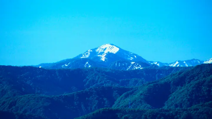
Mt. Daimonzan (1,571 m) straddles the prefectural boundary between Nanto City in Toyama and Kanazawa City in Ishikawa, in the northern Ryohaku mountain range. Its tidy conical profile has earned it the nickname Kaga Fuji, and the peak features in works by the writers Saisei Muro and Hiroyuki Itsuki. It is listed in Japan's 300 Famous Mountains, the 100 Mountains of Toyama and the Mountains of Ishikawa. The standard route follows the southwest ridge from Bunao Pass on the Toyama side, but Toyama Prefectural Road 54 to the pass has been closed for extended periods due to landslides, so hikers must check current access conditions before setting out.
Mt. Daimonzan at a glance
- Weather: The most settled day in the next 7 days is Wed, November 4: clear, gusts up to 6 m/s. Fri, Nov 6: strong wind (gusts up to 18 m/s).
Mt. Daimonzan weather (hourly, 14 days)
Sunrise today 06:17, sunset 16:56
| Tue, 11/3 | Wed, 11/4 | Thu, 11/5 | Fri, 11/6 | Sat, 11/7 | Sun, 11/8 | Mon, 11/9 | Tue, 11/10 | Wed, 11/11 | Thu, 11/12 | Fri, 11/13 | Sat, 11/14 | Sun, 11/15 | Mon, 11/16 | Tue, 11/17 | |||||||||||||||||||||||||||||||||||||||||||||||||||||||||||||||||||||||
|---|---|---|---|---|---|---|---|---|---|---|---|---|---|---|---|---|---|---|---|---|---|---|---|---|---|---|---|---|---|---|---|---|---|---|---|---|---|---|---|---|---|---|---|---|---|---|---|---|---|---|---|---|---|---|---|---|---|---|---|---|---|---|---|---|---|---|---|---|---|---|---|---|---|---|---|---|---|---|---|---|---|---|---|---|---|
| Japan time | 21 | 23 | 1 | 3 | 5 | 7 | 9 | 11 | 13 | 15 | 17 | 19 | 21 | 0 | 3 | 6 | 9 | 12 | 15 | 18 | 21 | 0 | 3 | 6 | 9 | 12 | 15 | 18 | 21 | 0 | 3 | 6 | 9 | 12 | 15 | 18 | 21 | 0 | 3 | 6 | 9 | 12 | 15 | 18 | 21 | 0 | 3 | 6 | 9 | 12 | 15 | 21 | 3 | 9 | 15 | 21 | 3 | 9 | 15 | 21 | 3 | 9 | 15 | 21 | 3 | 9 | 15 | 21 | 3 | 9 | 15 | 21 | 3 | 9 | 15 | 21 | 3 | 9 | 15 | 21 | 3 | 9 | 15 | 21 | |
  | | |  |   |   |  |   | | |   | | |   | |   |   | |   | | | | | |   |   | | | | |   | |   | | | | |   | |   | | | | | | | | | | | | | | | | | |   | | | | | | | | | | |  | | | | | | | | | | | | | | | | ||
| Temperature | °C | -1° | -1° | -2° | -2° | -3° | -2° | 4° | 8° | 9° | 8° | 5° | 5° | 6° | 4° | 4° | 4° | 8° | 12° | 10° | 7° | 6° | 6° | 5° | 5° | 5° | 7° | 4° | 2° | 1° | -1° | -2° | -3° | -2° | -2° | -3° | -3° | -4° | -4° | -4° | -4° | -1° | 1° | 1° | -3° | -2° | -1° | -1° | 0° | 4° | 6° | 3° | -1° | -2° | 3° | 6° | -1° | -5° | -4° | -1° | -3° | -7° | 0° | 1° | -3° | -1° | -1° | 1° | -4° | -6° | 3° | 5° | -1° | 0° | 5° | 5° | 5° | 6° | 4° | 1° | -2° | -3° | -1° | 1° | -1° |
| Precipitation | mm | 1.6 | 8 | 2.1 | 0.2 | 0.2 | 1.8 | 2.2 | 15 | 2.9 | 1.7 | 1.2 | 2.1 | 1.1 | 3.0 | 3.2 | 3.5 | 1.8 | 2.3 | 2.3 | 2.1 | 0.9 | 0.4 | 0.2 | 0.1 | 0.1 | 0.9 | 0.7 | 6 | 10 | 2.0 | 1.6 | 0.2 | 1.3 | 5 | 0.3 | 1.0 | 6 | 2.9 | 8 | 9 | 1.8 | 0.3 | 0.1 | |||||||||||||||||||||||||||||||||||||||||
| New snow | cm | <.1 | <.1 | 0.4 | 0.5 | 0.8 | 0.2 | 0.1 | <.1 | <.1 | <.1 | 4.1 | 1.6 | 0.3 | |||||||||||||||||||||||||||||||||||||||||||||||||||||||||||||||||||||||
| Snow depth | cm | 0 | 0 | 0 | 0 | 0 | 0 | 0 | 0 | 0 | 0 | 0 | 0 | 0 | 0 | 0 | 0 | 0 | 0 | 0 | 0 | 0 | 0 | 0 | 0 | 0 | 0 | 0 | 0 | 0 | 0 | 0 | 0 | <1 | <1 | <1 | <1 | <1 | <1 | <1 | <1 | <1 | <1 | 0 | 0 | 0 | 0 | 0 | 0 | 0 | 0 | 0 | 0 | 0 | 0 | 0 | 0 | 2 | 3 | 2 | 1 | 1 | 1 | <1 | <1 | <1 | 0 | 0 | 0 | 0 | 0 | 0 | 0 | 0 | 0 | 0 | 0 | 0 | 0 | 0 | 0 | 0 | 0 | 0 | 0 |
| Wind | m/s | 0 | 1 | 1 | 1 | 1 | 2 | 2 | 2 | 2 | 2 | 1 | 1 | 0 | 1 | 1 | 2 | 1 | 1 | 1 | 0 | 1 | 1 | 1 | 2 | 3 | 5 | 4 | 3 | 3 | 2 | 2 | 3 | 2 | 3 | 3 | 2 | 1 | 2 | 2 | 1 | 2 | 3 | 3 | 2 | 2 | 1 | 0 | 1 | 1 | 3 | 1 | 2 | 1 | 2 | 4 | 4 | 5 | 3 | 4 | 1 | 1 | 0 | 3 | 2 | 1 | 3 | 4 | 1 | 1 | 2 | 2 | 3 | 3 | 4 | 3 | 3 | 2 | 3 | 4 | 2 | 2 | 2 | 3 | 1 |
| Wind gusts | m/s | 3 | 2 | 3 | 3 | 4 | 6 | 6 | 6 | 6 | 6 | 5 | 4 | 4 | 4 | 6 | 7 | 6 | 5 | 5 | 4 | 6 | 9 | 8 | 9 | 10 | 16 | 18 | 14 | 11 | 11 | 9 | 11 | 10 | 11 | 10 | 9 | 9 | 7 | 8 | 9 | 7 | 9 | 10 | 9 | 6 | 7 | 4 | 4 | 6 | 11 | 10 | 7 | 6 | 7 | 13 | 14 | 18 | 18 | 14 | 13 | 5 | 4 | 9 | 8 | 8 | 11 | 11 | 11 | 5 | 7 | 7 | 7 | 8 | 11 | 11 | 13 | 16 | 11 | 14 | 13 | 9 | 6 | 8 | 7 |
| Wind dir. | ↓ | ↓ | ↓ | ↓ | ↓ | ↓ | ↓ | ↓ | ↓ | ↓ | ↓ | ↓ | ↓ | ↓ | ↓ | ↓ | ↓ | ↓ | ↓ | ↓ | ↓ | ↓ | ↓ | ↓ | ↓ | ↓ | ↓ | ↓ | ↓ | ↓ | ↓ | ↓ | ↓ | ↓ | ↓ | ↓ | ↓ | ↓ | ↓ | ↓ | ↓ | ↓ | ↓ | ↓ | ↓ | ↓ | ↓ | ↓ | ↓ | ↓ | ↓ | ↓ | ↓ | ↓ | ↓ | ↓ | ↓ | ↓ | ↓ | ↓ | ↓ | ↓ | ↓ | ↓ | ↓ | ↓ | ↓ | ↓ | ↓ | ↓ | ↓ | ↓ | ↓ | ↓ | ↓ | ↓ | ↓ | ↓ | ↓ | ↓ | ↓ | ↓ | ↓ | ↓ | |
Huts, campsites and lodging near Mt. Daimonzan
Lodging
- 桂湖コテージ
Lists that include Mt. Daimonzan
Japan's 300 Famous Mountains · 100 Mountains of Hokuriku · 100 Mountains of Toyama · Elevations of 1003 Mountains of Japan · 1000 Mountains of Japan
Mt. Daimonzan facts
- Also known as
- 加賀富士
- Elevation
- 1,571 m
- Location
- Kanazawa, Ishikawa
36.365228, 136.803684 - Website
- www.pref.toyama.jp
- Trail Map
- www.pref.toyama.jp (PDF)
- Access Information
- www.pref.toyama.jp
- Wikipedia
- ja.wikipedia.org