
Mt. Oshiromori
大白森
Semboku, Akita / Shizukuishi, Iwate · Elevation 1,216 m
Oshiromori (1,216 m) rises on the border of Shizukuishi, Iwate Prefecture, and Semboku, Akita Prefecture, on the ridge linking the Hachimantai plateau with the Nyuto hot-spring district. Within Towada-Hachimantai National Park, its summit holds a broad high-moor dotted with ponds. Lying along the traverse from Hachimantai to Nyuto Onsen, it appears on lists such as the "100 Famous Mountains of Tohoku" and the "100 Famous Mountains of Iwate."
Mt. Oshiromori at a glance
- Weather: The most settled day in the next 7 days is Wed, November 4: clear, gusts up to 12 m/s. Fri, Nov 6, Sat, Nov 7, Sun, Nov 8: strong wind (gusts up to 24 m/s).
Mt. Oshiromori weather (hourly, 14 days)
Sunrise today 06:07, sunset 16:34
| Tue, 11/3 | Wed, 11/4 | Thu, 11/5 | Fri, 11/6 | Sat, 11/7 | Sun, 11/8 | Mon, 11/9 | Tue, 11/10 | Wed, 11/11 | Thu, 11/12 | Fri, 11/13 | Sat, 11/14 | Sun, 11/15 | Mon, 11/16 | Tue, 11/17 | |||||||||||||||||||||||||||||||||||||||||||||||||||||||||||||||||||||||
|---|---|---|---|---|---|---|---|---|---|---|---|---|---|---|---|---|---|---|---|---|---|---|---|---|---|---|---|---|---|---|---|---|---|---|---|---|---|---|---|---|---|---|---|---|---|---|---|---|---|---|---|---|---|---|---|---|---|---|---|---|---|---|---|---|---|---|---|---|---|---|---|---|---|---|---|---|---|---|---|---|---|---|---|---|---|
| Japan time | 15 | 17 | 19 | 21 | 23 | 1 | 3 | 5 | 7 | 9 | 11 | 13 | 15 | 18 | 21 | 0 | 3 | 6 | 9 | 12 | 15 | 18 | 21 | 0 | 3 | 6 | 9 | 12 | 15 | 18 | 21 | 0 | 3 | 6 | 9 | 12 | 15 | 18 | 21 | 0 | 3 | 6 | 9 | 12 | 15 | 18 | 21 | 0 | 3 | 6 | 9 | 15 | 21 | 3 | 9 | 15 | 21 | 3 | 9 | 15 | 21 | 3 | 9 | 15 | 21 | 3 | 9 | 15 | 21 | 3 | 9 | 15 | 21 | 3 | 9 | 15 | 21 | 3 | 9 | 15 | 21 | 3 | 9 | 15 | |
  |   | |   |  | | | | |  | | |   | | | | |   |   | | | | | | | | | | | |   | |   | |   | |   |   | | | | | | |   | | | | |   | | | | | | | | |   | |   | |   | | | | | | | | | |  | | | | | | | | | | | | ||
| Temperature | °C | 2° | 0° | -1° | -1° | -2° | -2° | -1° | 0° | 1° | 4° | 6° | 7° | 5° | 1° | 1° | 1° | 2° | 4° | 6° | 7° | 7° | 6° | 6° | 6° | 6° | 6° | 7° | 8° | 6° | 2° | -1° | -2° | -3° | -4° | -3° | -2° | -3° | -4° | -4° | -4° | -4° | -4° | -3° | -2° | -2° | -3° | -3° | -3° | -3° | -5° | -2° | -2° | -4° | -6° | -2° | 1° | -2° | -1° | -2° | -2° | -4° | -5° | -1° | 0° | -1° | -2° | -3° | -3° | -6° | -7° | -1° | 1° | -4° | -4° | 3° | 4° | 2° | 2° | 3° | -1° | -5° | -6° | -2° | -1° |
| Precipitation | mm | 0.3 | 3.8 | 4.5 | 1.3 | 0.9 | 0.3 | 2.9 | 1.9 | 0.7 | 1.0 | 3.5 | 3.8 | 0.9 | 2.2 | 1.3 | 1.5 | 1.5 | 1.4 | 2.0 | 2.1 | 1.2 | 0.4 | 0.2 | 0.3 | 0.2 | 0.3 | 0.2 | 1.5 | 7 | 7 | 4.4 | 0.1 | 0.2 | 0.3 | 4.2 | 1.5 | 3.2 | 1.6 | 2.8 | 2.9 | ||||||||||||||||||||||||||||||||||||||||||||
| New snow | cm | <.1 | 0.2 | 0.6 | 1.2 | 1.5 | 1.4 | 2.0 | 2.1 | 1.2 | 0.4 | 0.2 | 0.3 | 0.2 | <.1 | <.1 | <.1 | <.1 | 0.3 | 0.1 | <.1 | 1.5 | 3.3 | 5.0 | 4.2 | <.1 | <.1 | <.1 | <.1 | 2.5 | <.1 | <.1 | 0.3 | 2.5 | <.1 | <.1 | |||||||||||||||||||||||||||||||||||||||||||||||||
| Snow depth | cm | <1 | <1 | <1 | <1 | <1 | <1 | <1 | <1 | <1 | <1 | 0 | 0 | 0 | 0 | 0 | 0 | 0 | 0 | 0 | 0 | 0 | 0 | 0 | 0 | 0 | 0 | 0 | 0 | 0 | 0 | <1 | <1 | 1 | 2 | 3 | 4 | 5 | 6 | 6 | 6 | 6 | 6 | 6 | 5 | 5 | 5 | 5 | 5 | 5 | 5 | 5 | 5 | 5 | 5 | 5 | 4 | 5 | 6 | 9 | 11 | 11 | 11 | 11 | 10 | 10 | 11 | 11 | 11 | 11 | 11 | 11 | 10 | 10 | 10 | 10 | 8 | 8 | 7 | 6 | 5 | 6 | 6 | 6 | 5 |
| Wind | m/s | 6 | 4 | 4 | 3 | 1 | 2 | 2 | 3 | 4 | 5 | 4 | 4 | 2 | 1 | 2 | 2 | 3 | 3 | 2 | 2 | 2 | 2 | 1 | 1 | 1 | 1 | 2 | 6 | 5 | 6 | 7 | 6 | 5 | 6 | 6 | 8 | 7 | 7 | 7 | 6 | 6 | 6 | 8 | 9 | 7 | 5 | 5 | 4 | 4 | 1 | 4 | 3 | 1 | 2 | 1 | 3 | 7 | 1 | 4 | 4 | 2 | 1 | 2 | 3 | 1 | 1 | 4 | 5 | 3 | 2 | 2 | 1 | 0 | 0 | 0 | 1 | 1 | 0 | 1 | 4 | 5 | 3 | 3 | 2 |
| Wind gusts | m/s | 16 | 15 | 11 | 10 | 9 | 7 | 8 | 9 | 10 | 12 | 12 | 11 | 9 | 4 | 4 | 6 | 7 | 8 | 8 | 7 | 5 | 5 | 5 | 4 | 5 | 5 | 7 | 18 | 18 | 17 | 17 | 17 | 16 | 17 | 20 | 23 | 24 | 21 | 19 | 18 | 17 | 17 | 20 | 22 | 22 | 20 | 13 | 12 | 10 | 10 | 11 | 10 | 9 | 6 | 6 | 9 | 18 | 17 | 11 | 16 | 10 | 6 | 7 | 11 | 8 | 4 | 11 | 13 | 13 | 8 | 6 | 8 | 5 | 2 | 3 | 6 | 5 | 6 | 4 | 12 | 15 | 12 | 9 | 9 |
| Wind dir. | ↓ | ↓ | ↓ | ↓ | ↓ | ↓ | ↓ | ↓ | ↓ | ↓ | ↓ | ↓ | ↓ | ↓ | ↓ | ↓ | ↓ | ↓ | ↓ | ↓ | ↓ | ↓ | ↓ | ↓ | ↓ | ↓ | ↓ | ↓ | ↓ | ↓ | ↓ | ↓ | ↓ | ↓ | ↓ | ↓ | ↓ | ↓ | ↓ | ↓ | ↓ | ↓ | ↓ | ↓ | ↓ | ↓ | ↓ | ↓ | ↓ | ↓ | ↓ | ↓ | ↓ | ↓ | ↓ | ↓ | ↓ | ↓ | ↓ | ↓ | ↓ | ↓ | ↓ | ↓ | ↓ | ↓ | ↓ | ↓ | ↓ | ↓ | ↓ | ↓ | ↓ | ↓ | ↓ | ↓ | ↓ | ↓ | ↓ | ↓ | ↓ | ↓ | ↓ | ↓ | |
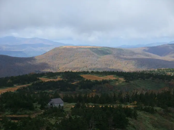
Huts, campsites and lodging near Mt. Oshiromori
Mountain huts
- 大白森山荘 unstaffed
- 大白森避難小屋
Lodging
- Tsuru-no-yu Onsen
- 蟹場温泉
- 大釜温泉
- Nyuto Onsenkyo Taenoyu
- 孫六温泉
Lists that include Mt. Oshiromori
Mt. Oshiromori facts
- Elevation
- 1,216 m
- Location
- Semboku, Akita / Shizukuishi, Iwate
39.841948, 140.785064 - National Park
- 十和田八幡平国立公園
- Website
- www.env.go.jp
- Wikipedia
- ja.wikipedia.org